Bláfell (Bláskógabyggð)
| Bláfell | ||
|---|---|---|
|
Bláfell behind the Hvítárgljúfur canyon and the Gullfoss waterfall |
||
| height | 1204 m | |
| location | Iceland | |
| Coordinates | 64 ° 30 ′ 0 ″ N , 19 ° 51 ′ 0 ″ W | |
|
|
||
| Type | Tabular volcano (extinct) | |
| rock | Palagonite , pillow lava , olivine basalt | |
| Last eruption | in the ice age | |
|
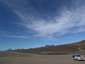
Driveway to the Bláfellsháls |
||
Bláfell (also Bláfellshnjúkur ) a mountain in the highlands of Iceland in the Árnessýsla district . It is located in the municipality of Bláskógabyggð and is 1204 meters high.
location
The mountain is located on the Kjölur highland route about 30 km north of the Gullfoss waterfall .
geology
Bláfell was formed in one of the last cold ages of the Ice Age . It is a tabular volcano , the lower layers of which are made of palagonite and pillow lavas , while the upper layers are made of olivine basalt .
Bláfellsháls pass
The highland piste Kjölur winds up on its west side, leads over a pass halfway up the mountain and north of it on the plateau towards Hveravellir . The Kjölur route connects the south of Iceland, more precisely the district of Árnessýsla with the north of Iceland (district of Húnavatnssýsla).
The route over the Bláfellsháls Pass was not popular in earlier times due to the altitude and weather uncertainty. Travelers across the Kjölur tended to follow the Hvítá valley .
Folk tale
A legend tells of the good-natured troll Bergþór, who spent a large part of his life in a cave in Bláfell (hence his nickname Bergþór í Bláfelli ). He was close friends with the farmer of the Haukadalur farm (near the geyser) and was even buried there in the churchyard.
hike
In the north-east there is a large cairn on the Bláfellsháls pass, from where you have an excellent view of the Langjökull ice cap . A little further north, a mountain ledge extends to the pass, which is easy to climb over.
See also
- Geography of Iceland
- History of Iceland
- Volcanoes in Iceland
- List of mountains and elevations in Iceland


