
Black Belt (region)
As a Black Belt ( English for Black Belt ) is an area in the southern states of the United States referred to the cotton plantation economy because of its dark, fertile soil and later because of the high percentage of the time African Americans has been called so. There are various proposals for delimitation for this belt region .
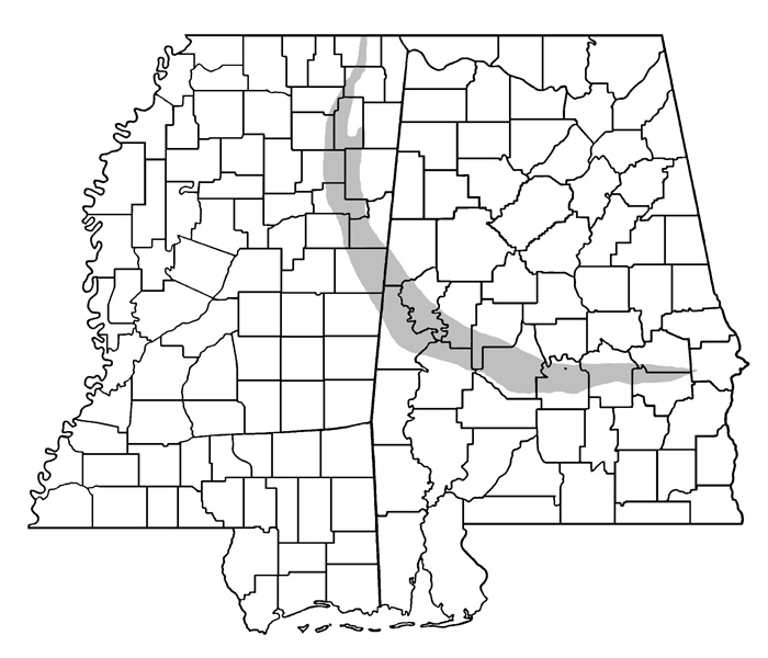
Black Belt as a physiogeographic term
As early as the 19th century, the term Black Belt was used for an area in the sense of physical geography in the states of Mississippi and Alabama , which was given this name because of its fertile, dark, calcareous soil. This Black Belt is a narrow, long band around 480 km long and 40–50 km wide. It runs from the northern border of the state of Mississippi in a southeasterly direction into central Alabama. The area was one of the main cotton growing areas until the Civil War . In addition to cotton cultivation, cattle breeding and the cultivation of soybeans are currently widespread here.
Black Belt as a sociological term

In addition to the physiogeographical term, Black Belt was later used as a term in sociology and denotes the regions of the southern states with a high proportion of African Americans in the total population. The sociologist Arthur F. Raper defined the term in 1936 as the totality of the approximately 200 counties with a share of African Americans over 50 percent. A study commissioned by the University of Kentucky and published in 1997 by Ronald C. Wimberly and Libby V. Morris defines the Black Belt as a largely contiguous area of 623 counties in the eleven southern states of Alabama, Arkansas , Florida , Georgia , Louisiana , Mississippi, North Carolina , South Carolina , Tennessee , Texas, and Virginia . These counties are predominantly rural, economically weak and have a proportion of African Americans that is above the US average. In the 2000 census, Jefferson County, Mississippi, had the highest percentage of African Americans at 86.5 percent of all counties. The Black Belt, as defined by Wimberly and Morris, has the lowest per capita income, the lowest average educational standard and the highest unemployment of all regions of the USA. In the Black Belt are essentially those counties in the southern states, which are politically influenced by the Republican Party , in which the Democratic Party candidate receives a majority in presidential elections .
Web links
- Black Belt in the Encyclopaedia Britannica (English)
Individual evidence
- ↑ Mississippi State University: The Black Belt in the physical-geographic sense on a map of the states Mississippi and Alabama (shown in gray) accessed March 15, 2010
- ^ Arthur F. Raper: Preface to Peasantry. A Tale of Two Black Belt Counties. University of North Carolina Press, Chapel Hill 1936.
- ↑ Ronald C. Wimberly, Libby V. Morris: The Southern Black Belt: A National Perspective. University of Kentucky, Lexington 1997, ISBN 0-9649-7462-2 . (Summary, accessed March 15, 2010) ; Samuel D. Calhoun, Richard J. Reeder, Faqir S. Bagi: Federal Funds in the Black Belt ( Memento April 4, 2012 in the Internet Archive ). In: Rural America. Volume 15, 2000, No. 1, pp. 20-27.
- ↑ From picking 'Cotton to Pickin' Presidents ( Memento of January 2, 2010 in the Internet Archive ). In: Strange Maps (Weblog), November 15, 2008.