Black Fork (Cheat River)
| Black fork | ||
|
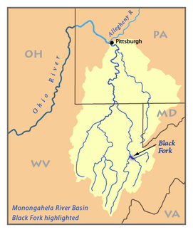
Catchment area of the Monongahela River with the Black Fork. |
||
| Data | ||
| Water code | US : 1550368 | |
| location | Tucker County in West Virginia (USA) | |
| River system | Mississippi River | |
| Drain over | Cheat River → Monongahela River → Ohio River → Mississippi River → Gulf of Mexico | |
| Confluence of |
Dry Fork and Blackwater River at Hendricks, WV 39 ° 4 ′ 20 ″ N , 79 ° 37 ′ 45 ″ W |
|
| Source height | 518 m | |
| Association with |
Shavers Fork in Parsons to the Cheat River Coordinates: 39 ° 6 ′ 39 ″ N , 79 ° 40 ′ 44 ″ W 39 ° 6 ′ 39 ″ N , 79 ° 40 ′ 44 ″ W. |
|
| Mouth height | 494 m | |
| Height difference | 24 m | |
| Bottom slope | 3.7 ‰ | |
| length | 6.5 km | |
| Catchment area | 1295 km² | |
| Small towns | Parsons , Hendricks | |
|
Formation of the Black Fork by the confluence of the Blackwater River (left) and Dry Fork (right) near Hendricks, West Virginia. |
||
The Black Fork is only 6 km long headwaters of the Cheat River in the east of the US state West Virginia .
It belongs to the catchment area of the Mississippi River and drains an area of 1295 km². It is created by the confluence of the Blackwater River and Dry Fork in Hendricks . In Parsons , the Black Fork then flows together with the Shavers Fork and forms the Cheat River with it .
geography
About the Cheat River, Monongahela River and Ohio River , the Black Fork belongs to the catchment area of the Mississippi River and drains an area of 1295 km². The river runs along its entire length within Tucker County . After it was formed at Hendricks by Dry Fork and Blackwater River, it flows in a north-westerly direction via Hambleton to Parsons, where it merges with the Shavers Fork to form the Cheat River.
Naming
The US Board on Geographic Names set the name of the watercourse to "Black Fork" in 1930. According to the information in the Geographic Names Information System , the river was historically known as the "Blackwater Fork" and was also referred to as part of the Blackwater River .
See also
literature
- Julian, Norman. 2006. "Cheat River". The West Virginia Encyclopedia . Ken Sullivan (Editor). Charleston, WV. West Virginia Humanities Council. ISBN 0-9778498-0-5 .
Web links
Individual evidence
- ↑ The American Rivers Outstanding Rivers List , Second Edition, May 1991. Compiled and edited by Matthew H. Huntington and John D. Echeverria. Washington DC American Rivers, Inc.
- ↑ a b DeLorme (1997). West Virginia Atlas & Gazetteer . Yarmouth, Maine: DeLorme. ISBN 0-89933-246-3 .
- ^ West Virginia Department of Environmental Protection. Cheat River watershed ( Memento of the original from October 4, 2006 in the Internet Archive ) Info: The archive link was automatically inserted and not yet checked. Please check the original and archive link according to the instructions and then remove this notice. . Sum of the drainage areas of Dry Fork, Blackwater River, Glady Fork, Laurel Fork, Gandy Creek, and Red Creek. Retrieved January 27, 2008.
- ↑ Black Fork in the Geographic Names Information System of the United States Geological Survey

