Blackwater River (Black Fork)
| Blackwater River | ||
|
Course of the river |
||
| Data | ||
| Water code | US : 1550382 | |
| location | Tucker County in West Virginia (USA) | |
| River system | Mississippi River | |
| Drain over | Black Fork → Cheat River → Monongahela River → Ohio River → Mississippi River → Gulf of Mexico | |
| source |
Canaan Valley 39 ° 3 ′ 32 " N , 79 ° 29 ′ 4" W. |
|
| Source height | 991 m | |
| Association with |
Dry fork to the black fork in Hendricks coordinates: 39 ° 4 ′ 20 " N , 79 ° 37 ′ 45" W 39 ° 4 ′ 20 " N , 79 ° 37 ′ 45" W |
|
| Mouth height | 518 m | |
| Height difference | 473 m | |
| Bottom slope | 9.5 ‰ | |
| length | 50 km | |
| Catchment area | 368 km² | |
| Drain |
MQ |
5 m³ / s |
| Left tributaries | Little Blackwater River | |
| Right tributaries | North Branch Blackwater River | |
| Small towns | Hendricks , Davis | |
|
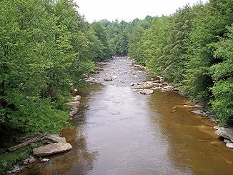
The Blackwater River in Blackwater Falls State Park |
||
|
Blackwater River Canyon in Blackwater Falls State Park |
||
|
The Blackwater River on the upper reaches in Canaan Valley Resort State Park |
||
|
North Fork of the Blackwater River in Thomas, WV |
||
|
The Elakala Waterfall on the Blackwater River in West Virginia, USA. |
||
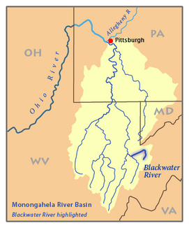
The Blackwater River ( English for " Blackwater River ") is a 50 km long river in the Allegheny Mountains of eastern West Virginia in the United States .
It is a tributary of the Cheat River via the Black Fork .
About this, the Monongahela River and the Ohio River it is part of the catchment area of the Mississippi River and drains an area of 368 km².
geography
The Blackwater River is a so-called black water river , which also gave him the name. The entire course of the river is within Tucker County . It rises at a height of 991 m and first crosses the wetlands of the Canaan Valley in the Canaan Valley Resort State Park and in the Canaan Valley National Wildlife Refuge . Then he takes on the two tributaries North Branch Blackwater River and Little Blackwater River . Then he turns to the southwest for the remainder of his run.
After flowing past the town of Davis, the river plunges over Blackwater Falls in Blackwater Falls State Park 17 meters and enters the 12.5 km long Blackwater Canyon . In Hendricks it merges with the dry fork and forms the black fork . The mouth is at a height of 520 m.
Hydrography
The United States Geological Survey operates two gauges on the Blackwater River near Davis . At the gauge below Davis, the average annual runoff is 5 m³ / s.
Rehabilitation of the river
The treatment of mine water in the Blackwater catchment area was recognized by the Office of Surface Mining for its success . Acidic mine water occurs when strata with sulphite minerals are exposed to the effects of air and rainwater. This is the case when mining is done in the form of open pit mining . The resulting sulfuric acid can dissolve metals such as iron , aluminum and magnesium . By 2004, the association of acids and dissolved heavy metals in the Appalachian Mountains had damaged over 19,300 km of waterways, including the Blackwater Rivers and its tributaries.
The rehabilitation of the Blackwater River and its catchment area was costly and a complex project that consisted of two large parts.
As part of the Douglas Highwall Abandoned Mine Land Reclamation Project, 14,400 tons of limestone were brought into the North Branch of the Blackwater River below Thomas. Although the experimental system did not work as intended and did not create a measurable increase in the base level, the total amount of acids and heavy metals dissolved in the water from the abandoned mine into the river system was significantly reduced.
A project directly above Davis on Beaver Creek , a tributary of the Blackwater River, was more successful . A limestone mill powered by water power mixes this into the water.
A dosing system developed in Sweden for sprinkling ground limestone was installed as an additional measure. The five-mile stretch between the station and the confluence of the Blackwater River with the North Branch is now one of the best stretches of the river for catching trout .
Web links
- Blackwater River in the United States Geological Survey's Geographic Names Information System
- Level of the Blackwater River four kilometers northeast of Davis (measuring point 03065400, English, in real time)
- Level of the Blackwater River around 650 m southwest of Davis (measuring point 03066000, English, in real time)
- Blackwater Falls State Park website (English)
- Canaan Valley Resort State Park website (English)
- Canaan Valley National Wildlife Refuge website (English)
Individual evidence
- ↑ a b c Patricia Hissom: Blackwater River. In: Ken Sullivan (Ed.): The West Virginia Encyclopedia. West Virginia Humanities Council, Charleston 2006, ISBN 0-9778498-0-5 .
- ↑ North Branch Blackwater River in the Geographic Names Information System of the United States Geological Survey
- ↑ Little Blackwater River in the Geographic Names Information System of the United States Geological Survey
- ^ DeLorme (eds.): West Virginia Atlas & Gazetteer. DeLorme, Yarmouth 1997, ISBN 0-89933-246-3 .
- ↑ Norma Jean Kennedy-Venable: Blackwater Falls. In: Ken Sullivan (Ed.): The West Virginia Encyclopedia. West Virginia Humanities Council, Charleston 2006, ISBN 0-9778498-0-5 .
- ^ Annual average discharge for Blackwater River at Davis, WV . United States Geological Survey (USGS), as of 2005; Retrieved March 17, 2007.
- ^ US Office of Surface Mining 1999 Award ( Memento June 14, 2008 in the Internet Archive ), website accessed on January 21, 2008
- ↑ PL Sibrell, Barnaby J. Watten, AE Friedrich, BJ Vinci: ARD remediation with Limestone in a CO2 Pressurized Reactor . (PDF; 131 kB) Denver, May 2000.
- ^ T. Williams: Coal Country Trout . ( Memento of the original from October 17, 2006 in the Internet Archive ) Info: The archive link was inserted automatically and has not yet been checked. Please check the original and archive link according to the instructions and then remove this notice. In: Fly Rod & Reel Magazine July / October 2004.
- ↑ a b J. Skousen, J. Gorman, P. Ziemkiewicz: Long Term Effects of Acid Mine Drainage Remediation Projects on Stream Quality. ( Memento of the original from May 10, 2006 in the Internet Archive ) Info: The archive link was automatically inserted and not yet checked. Please check the original and archive link according to the instructions and then remove this notice. In: Proceedings Twentieth Annual West Virginia Surface Mine Drainage Task Force Symposium. Morgantown 1999.
- ↑ a b P. E. Zurbuch: Early Results from Calcium Carbonate Neutralization of Two West Virginia Rivers Acidified by Mine Drainage. ( Memento of the original from May 10, 2006 in the Internet Archive ) Info: The archive link was automatically inserted and not yet checked. Please check the original and archive link according to the instructions and then remove this notice. In: Seventeenth Annual West Virginia Surface Mine Drainage Task Force Symposium. Morgantown 1996.
- ^ Mineral Information Institute website ( September 27, 2007 memento in the Internet Archive ), accessed August 26, 2006.
- ^ West Virginia Department of Natural Resources Special Fishing Regulations ( December 15, 2007 memento on the Internet Archive ). Retrieved January 22, 2008.


