Cheat River
| Cheat River | ||
|
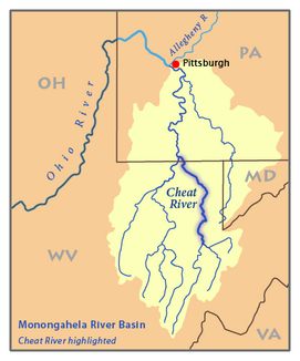
Map of the catchment area of the Monongahela River with the Cheat River |
||
| Data | ||
| Water code | US : 1171616 | |
| location | Pennsylvania , West Virginia (USA) | |
| River system | Mississippi River | |
| Drain over | Monongahela River → Ohio River → Mississippi River → Gulf of Mexico | |
| confluence | from Shavers Fork and Black Fork at Parsons, West Virginia, 39 ° 7 ′ 1 ″ N , 79 ° 40 ′ 51 ″ W |
|
| Source height | 1007 m | |
| muzzle | in the Monongahela River at Point Marion Coordinates: 39 ° 44 ′ 34 " N , 79 ° 54 ′ 8" W 39 ° 44 ′ 34 " N , 79 ° 54 ′ 8" W |
|
| Mouth height | 232 m | |
| Height difference | 775 m | |
| Bottom slope | 6.2 ‰ | |
| length | 125 km | |
| Catchment area | 3684 km² | |
| Drain |
MQ |
110 m³ / s |
| Left tributaries | Big Sandy Creek | |
| Reservoirs flowed through | Cheat Lake | |
|
The Cheat River at Rowlesburg, West Virginia |
||
The Cheat River is a 125-mile right tributary of the Monongahela River in eastern West Virginia and southwestern Pennsylvania in the United States . By the rivers Monongahela and Ohio it is part of the catchment area of the Mississippi River and drains an area of 3684 km².
geography
The Cheat River arises in Parsons at the confluence of Shavers Fork and Black Fork ; the Black Fork is fed by the Blackwater River , the Dry Fork , the Glady Fork , and the Laurel Fork . All of these are considered the primary arms of the Cheat River. From Parsons, the river flows generally north through Tucker and Preston Counties, passing through the towns of Rowlesburg and Albright . From Albright on, the river flows northeast and collects the waters of Big Sandy Creek before reaching Monongalia County , where a hydroelectric dam south of the Pennsylvania state line extends the river to Cheat Lake . It then flows for a short distance through the southwest of Fayette County before flowing into the Monongahela River at Point Marion . Above the dam, the Cheat River is one of the largest watercourses in the eastern United States without any dams.
The United States Geological Survey operates two gauge stations on the Cheat River . The average annual discharge of the Cheat River in Rowlesburg is 110 m³ / s, in Parsons near its source it is 105 m³ / s.
A few kilometers west of the confluence in Parsons is the northern end of the Cheat Mountains , an approximately 80 km long mountain range that runs south.
1985 flood
In November 1985, heavy rains caused a flood on the Cheat River, literally washing away most of the small town of Albright. The flow rate at the time was estimated at around 5400 m³ / s (compared to 30 to 140 m³ / s). During this severe flood, the town of Rowlesburg was also flooded, where the school was destroyed. This then led to the establishment of a high school for the entire county.
pollution
In the vicinity of Albright the river is polluted by mine water . Although the stones in the river below are rusty brown and there is only a small fish population in the river, the water quality has slowly improved since the 1990s.
Historical names
According to the Geographic Names Information System , the Cheat River also had the following names:
- Oh-sin-ha-nac
- Achsinhanac
- Cheal River
- Chealt River
- Eleat River
- Wilmoths River
Web links
Individual evidence
- ↑ Kosky, James PE; Lessons Learned: Cheat River and Tygart River Flood Warning Systems ( Memento from March 31, 2007 in the Internet Archive ) (PDF; 5.3 MB); Retrieved March 13, 2007.
- ↑ a b Cheat River in the Geographic Names Information System of the United States Geological Survey
- ↑ United States Geological Survey ; USGS 03069870 CHEAT RIVER AT HWY 50 NEAR ROWLESBURG, WV ; Retrieved March 13, 2007.
- ↑ United States Geological Survey ; USGS 03069500 CHEAT RIVER NEAR PARSONS, WV ; Retrieved March 13, 2007.
- ↑ Friends of the Cheat.org Friends of the Cheat

