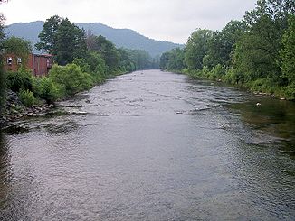
Shavers Fork
| Shavers Fork | ||
|
Monongahela River basin, Shavers Fork highlighted. |
||
| Data | ||
| Water code | US : 1552850 | |
| location | West Virginia (USA) | |
| River system | Mississippi River | |
| Drain over | Cheat River → Monongahela River → Ohio River → Mississippi River → Gulf of Mexico | |
| source | at Thorny Flat in Pocahontas County 38 ° 23 ′ 50 ″ N , 79 ° 59 ′ 9 ″ W |
|
| Source height | 1478 m | |
| Union | with the Black Fork in Parsons in Tucker County to the Cheat River Coordinates: 39 ° 6 ′ 39 ″ N , 79 ° 40 ′ 44 ″ W 39 ° 6 ′ 39 ″ N , 79 ° 40 ′ 44 ″ W |
|
| Mouth height | 494 m | |
| Height difference | 984 m | |
| Bottom slope | 6.9 ‰ | |
| length | 143 km | |
| Catchment area | 554 km² | |
| Drain at Bowden, West Virginia |
NNQ (1976) MQ HHQ |
2.8 m³ / s 14.6 m³ / s 27.3 m³ / s |
|
Shavers Fork in the Stuart Recreation Area in the Monongahela National Forest |
||
|
Shavers Fork in Parsons, West Virginia |
||
The Shavers Fork is a 143 km long tributary of the Cheat River in the US state of West Virginia .
It belongs to the catchment area of the Mississippi River and drains over the Cheat River, Monongahela River and Ohio River an area of 554 km² in a mostly forested, rural region.
geography
The Shavers Fork rises in the north of Pocahontas County on Thorny Flat , the highest peak on Cheat Mountain , at 1,478 m. Most of its river course runs through the Monongahela National Forest . 97% of the catchment area is forested and two thirds are publicly owned.
At its upper reaches, the river is the highest river in the eastern United States. There is also the ghost town of Spruce . It then flows northeast through Randolph County and Tucker County . The river valley lies in a trough between Cheat Mountain in the west and Shavers Mountain in the east.
River settlements include Cheat Bridge, Bemis, Bowden, and Porterwood. Together with the Black Fork it forms the Cheat River near Parsons at a height of 494 m .
Hydrology
The United States Geological Survey maintains a gauge at Bowden , 26.4 miles above the estuary . The mean annual discharge at this point is 14.6 m³ / s. The highest value ever measured was reached on November 19, 2003 with 650 m³ / s.
At the measuring station further upstream in Cheat Bridge , the average flow rate is 5.3 m³ / s.
Different names and spellings
According to the USGS's Geographic Names Information System, the Shavers Fork has a number of previous deviating names:
- Chavers Fork
- Main Cheat River
- Shafers fork
- Shaffer's Fork of Cheat River
- Shaver's fork
- Shavers Fork River
- Shavers Fork of Cheat River
Web links
Individual evidence
- ↑ a b c Shavers Fork in the Geographic Names Information System of the United States Geological Survey
- ↑ USGS 03068800 SHAVERS FORK BELOW BOWDEN, WV ( English ) In: National Water Information System . US Geological Survey . Retrieved April 24, 2008.
- ↑ a b Tanya Godfrey: Shavers Fork. In: Ken Sullivan: The West Virginia Encyclopedia. West Virginia Humanities Council, Charleston, WV 2006, ISBN 0-9778498-0-5 .
- ^ Bender, Steve (2002) "Cheat River: West Virginia" Southern Living , Southern Progress Corporation , Spring 2002.
- ^ DeLorme (1997). West Virginia Atlas & Gazetteer. Yarmouth, Maine: DeLorme. ISBN 0-89933-246-3 .
- ↑ United States Geological Survey (USGS); Table of Average Annual Discharges for Shavers Fork near Bowden, WV . Retrieved January 22, 2008.
- ↑ USGS 03067510 SHAVERS FORK NR CHEAT BRIDGE, WV ( English ) In: National Water Information System . US Geological Survey . Retrieved April 24, 2008.


