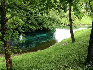
Blue spring
| Blue spring | |||
|---|---|---|---|
 The blue spring in Erl |
|||
| location | |||
| Country or region | District of Kufstein , Tyrol , ( Austria ) | ||
| Coordinates | 47 ° 40 ′ 11 " N , 12 ° 11 ′ 12" E | ||
| height | 471 m above sea level A. | ||
|
|||
| geology | |||
| Mountains | Chiemgau Alps | ||
| Source type | Karst spring | ||
| rock | limestone | ||
| Hydrology | |||
| River system | Danube | ||
| Receiving waters | Mühlgrabenbach → Trockenbach → Inn → Danube → Black Sea | ||
| Bulk | 751 l / s | ||
Coordinates: 47 ° 40 ′ 11 ″ N , 12 ° 11 ′ 12 ″ E
The Blue Spring is a karst spring in Erl in the Lower Inn Valley and the oldest natural monument in Tyrol .
description
The source lies at a height of 471 m above sea level. A. around 300 m southeast of the Erler Passion Playhouse. It feeds a spring pond that gave it its name with its clear, deep blue color. The sandy ground is covered with candelabrum algae . The pond is surrounded by a grove of horse chestnut , beech , oak , ash , linden and birch trees. The spring, pond and group of trees were the first to be declared a natural monument in Tyrol in 1926. The water flows over Mühlgrabenbach and Trockenbach to the Inn after about one kilometer .
Hydrology
Since 1992 there has been a spring measuring point (number 395434) of the Hydrographic Service Tyrol at the Blauer Quelle. Typically for a karst spring, the water flow increases rapidly when it rains. The mean spring discharge is 751 l / s (series 1992–2010), the minimum 291 l / s (measured on January 9, 1999), the maximum 2132 l / s (July 11, 2005). In contrast, the slight fluctuation in the water temperature of only 0.2 ° C is noticeable; it is almost constant at 8.1 ° C. The conductivity also varies only relatively slightly between 516 and 596 μS / cm with an average value of 581 μS / cm. The slight fluctuation in temperature and conductivity indicates a high proportion of deep karst water.
See also
Web links
Individual evidence
- ↑ Blue Source natural monument, Blauer Gumpen and the surrounding group of trees - Quellenensee. In: Tiris . Retrieved February 18, 2016 .
- ↑ a b Federal Ministry of Agriculture, Forestry, Environment and Water Management (Ed.): Source observation in the Hydrographic Service in Austria. Communications of the Hydrographic Central Office, Issue 70, Vienna 2005, Appendix 2 ( PDF; 9.4 MB ( Memento of the original from November 5, 2013 in the Internet Archive ) Info: The archive link has been inserted automatically and has not yet been checked. Please check the original and Archive link according to instructions and then remove this note. )
- ↑ a b Federal Ministry of Agriculture, Forestry, Environment and Water Management (Ed.): Hydrographisches Jahrbuch von Österreich 2010. 118th volume. Vienna 2012, p. Q31, PDF (12.6 MB) on bmlrt.gv.at (2010 yearbook)

