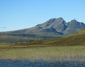
Blaven
| Blaven (Blà Bheinn) | ||
|---|---|---|
|
View of the Blaven from the east |
||
| height | 929 m ASL | |
| location | Highlands , Scotland | |
| Mountains | Cuillin Hills | |
| Coordinates | 57 ° 13 '10 " N , 6 ° 5' 35" W | |
|
|
||
The Blaven ( Gaelic : Blà Bheinn [ˈplˠ̪aːveɲ]) is a mountain on the Scottish island of Skye . It is part of the Cuillin Hills and with a height of 929 m one of the twelve Munros on the island.
etymology
The origin of the name Blaven or Blà Bheinn is not clear and possibly goes back to more than one language. So bla a Norse word for "blue" and Bheinn the Gaelic word for "mountain". Furthermore, Blà could also be interpreted as "flowers" (from the Gaelic word blath ).
Location and description
The Blaven is about 11 km (as the crow flies) west of Broadford , not far from Loch Slapin. Although the mountain is attributed to the so-called Black Cuillin due to its geological composition , it is located as an eastern outpost outside this subgroup and rather in geographical proximity to the Red Cuillin . The Blaven has a double peak , the actual main peak being a few meters higher than the neighboring southern peak.
Ascent
The Blaven is usually approached from the east. Starting from the banks of Loch Slapin , you first follow the course of the Allt na Dunaiche river through heathland . Then you circle the offshore mountain An Stac ( 528 m ) in a south-westerly direction. Approximately at the level of the small mountain lake Loch Fionna-choire , there are two routes that lead over scree to the summit of the Blaven. Both routes are steep and contain smaller climbing sections. The ascent is therefore not without risk, especially in unfavorable weather conditions or inadequate climbing experience. The mountain top is marked by a triangulation point and, when the weather is clear, offers an excellent view of the main group of Black Cuillin in the west, as well as more distant peaks of the Scottish mainland in the east.
Web links
- blaven.com - Information page (English)
- Bla Bheinn on hill-bagging.co.uk - information site with maps and GPS data
Individual evidence
- ^ Database of British and Irish Hills: Bla Bheinn . Retrieved December 20, 2019 .
- ↑ Steve Kew: Walking the Munros Vol 2 - Northern Highlands and the Cairngorms , Cicerone Press Limited, 2017, ISBN 978-1-85284-931-3 , p. 27
- ↑ Kathryn M. Goodenough: The Geological Assets of Broadford and Strath: Statement of Significance and Identification of Opportunities , Geology and Landscape (Northern Britain) Program (Report CR / 06 / 075N), 2006, http://nora.nerc.ac .uk / id / eprint / 7449 , p. 7th

