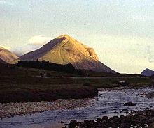
Cuillin Hills
| Cuillin Hills | ||
|---|---|---|
| Highest peak | Sgurr Alasdair ( 992 m ASL ) | |
| location | Scotland / United Kingdom | |
| part of | Isle of Skye | |
|
|
||
| Coordinates | 57 ° 12 ′ N , 6 ° 12 ′ W | |
| rock | Gabbro, basalt, granite | |
The Cuillin Hills ( Scottish Gaelic : An Cuilthionn or An Cuiltheann ) are a rocky mountain landscape on the Scottish island of Skye , part of the Inner Hebrides .
They are made up of the Black Cuillin and the Red Cuillin (or Red Hills ). Glen Sligachan stretches between these two massifs in a north-south direction. Under (The) Cuillin only the chain is often in the narrow sense Black Cuillin understood. The name Red Cuillin has - especially on Skye itself - only a subordinate meaning.
The highest point of the Cuillin Hills is the 992 m high Sgurr Alasdair in the Black Cuillin . It is also the highest point on the Isle of Skye.
Black Cuillin
The Black Cuillin consist mainly of basalt and gabbro . The name Black (Eng. "Black") Cuillin is derived from the dark color of the gabbro. The ridge of the Black Cuillin is characterized by rugged, bare rock, steep cliffs and deeply cut karen and gullies. All twelve Munros on the Isle of Skye are in the Black Cuillin. Of this, however, the Blaven (Scottish Gaelic: Blà Bheinn ) is a special case: It belongs to a mountain group that, like the Red Cuillin, is separated from the main chain of the Black Cuillin by the Glen Sligachan. A well-known hiking and climbing tour in the Black Cuillin is the crossing of the entire chain of peaks ( Black Cuillin (Ridge) Traverse ).
Red Cuillin (The Red Hills)

The Red Cuillin or Red Hills (Scottish Gaelic: Am Binnean Dearg ) consist mainly of granite , which, depending on the incidence of light and viewing angle, appears slightly reddish in contrast to the dark gray of the Black Cuillin. Due to weathering, the shapes of the mountains are more rounded than in the Black Cuillin, the vegetation extends up to the summit. The flanks are dominated by long scree slopes.
The highest point of the Red Cuillin is the Glamaig .
Major peaks
The following list includes the Munros, Corbetts and Grahams of the Cuillin Hills. Not included in the list are (minor) peaks such as the Clach Glas .
| summit | Height (m) | Notch height (m) | Cuillin | |
|---|---|---|---|---|
| 1 | Sgùrr Alasdair | 992 | 992 | Black |
| 2 | Sgùrr Dearg | 986 | 182 | Black |
| 3 | Sgùrr a 'Ghreadaidh | 973 | approx. 123 | Black |
| 4th | Sgùrr na Banachdich | 965 | approx. 114 | Black |
| 5 | Sgùrr nan Gillean | 964 | approx. 204 | Black |
| 6th | Bruach na Frìthe | 958 | about 125 | Black |
| 7th | Sgùrr Mhic Choinnich | 948 | approx. 56 | Black |
| 8th | Sgùrr Dubh Mòr | 944 | approx. 89 | Black |
| 9 | At the basteir | 934 | approx. 55 | Black |
| 10 | Blaven (Blà Bheinn) | 929 | 301 | Blaven group |
| 11 | Sgùrr nan Eag | 924 | approx. 127 | Black |
| 12 | Sgùrr a 'Mhadaidh | 918 | approx. 71 | Black |
| 13 | Garbh-bheinn | 808 | 172 | Blaven group |
| 14th | Glamaig | 775 | approx. 480 | Red |
| 15th | Marsco | 736 | 413 | Red |
| 16 | Beinn Dearg Mhòr | 731 | 152 | Red |
| 17th | Belig | 702 | 246 | Blaven group |
Maps
- Ordnance Survey : OS Outdoor Leisure 8 - The Cuillin & Torridon Hills , scale 1: 25000, Ordnance Survey, Southampton (Great Britain) 1995, ISBN 978-0319260081
- Ordnance Survey: OS Land Ranger Map 32 - South Skye & Cuillin Hills , scale 1: 50000, Ordnance Survey, Southampton (Great Britain) 2007, ISBN 978-0319229903

