Blavet (Var)
| Blavet | ||
|
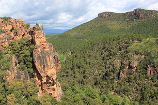
Blavet Gorge near Bagnols-en-Forêt |
||
| Data | ||
| Water code | FR : Y5310540 | |
| location | France , Provence-Alpes-Cote d'Azur region | |
| River system | Argens | |
| Drain over | Argens → Mediterranean | |
| source | in the municipality of Bagnols-en-Forêt 43 ° 32 ′ 43 ″ N , 6 ° 41 ′ 55 ″ E |
|
| Source height | approx. 305 m | |
| muzzle | in the municipality of Roquebrune-sur-Argens in the Argens coordinates: 43 ° 27 ′ 9 ″ N , 6 ° 39 ′ 8 ″ E, 43 ° 27 ′ 9 ″ N , 6 ° 39 ′ 8 ″ E |
|
| Mouth height | approx. 8 m | |
| Height difference | approx. 297 m | |
| Bottom slope | approx. 20 ‰ | |
| length | 15 km | |
The Blavet is a small river in France that runs in the Var department in the Provence-Alpes-Côte d'Azur region . It rises in the municipal area of Bagnols-en-Forêt , generally drains south-west to south and flows into the Argens as a left tributary after 15 kilometers in the municipality of Roquebrune-sur- Argens .
Places on the river
- Bagnols-en-Forêt
- La Bouverie , municipality of Roquebrune-sur-Argens
Attractions
The Blavet Gorge ( Gorges du Blavet ) is located between Bagnols-en-Forêt and the La Bouverie district of Roquebrune-sur-Argens. Among other things, there are a number of caves in which traces of Homo erectus and the early Homo sapiens have been discovered during archaeological excavations .
Web links
Commons : Blavetschlucht - Collection of pictures, videos and audio files
Remarks
- ↑ Source geoportail.fr (1: 32,000)
- ↑ mouth geoportail.fr (1: 32,000)
- ↑ a b The information on the length of the river is based on the information about the Blavet at SANDRE (French), accessed on April 15, 2012, rounded to full kilometers.
