
Bockwa mining nature trail

The mining trail Bockwa is a Opened on September 7, 1996 mining trail in Zwickau coal district . The path symbol is a white square with a green band running diagonally from top left to bottom right.
history

After the Technology Working Group of the Zwickau Coal Mining Working Group had already opened the Schedewitz – Oberhohndorf educational trail in 1995 , the second educational trail for mining followed a year later, dealing with the Bockwaer Revier.
At the beginning of the 2000s, the original notice boards had to be replaced by stainless steel boards due to vandalism.
Bockwaer district
The coal mining in the corridors of the village of Bockwa, first mentioned in 1458, is the second oldest in the Zwickau district after the Planitzer . For centuries it was shaped by the coal farmers who mined the hard coal under their fields in winter, which was relatively close to the day. In Bockwa the common land still applied , so that the coal under the common lands belonged to all residents. This found its expression in the 19th century in the old community shafts ( coal mine Altgemeinde Bockwa ; Altgemeinde = common land).
Geographically and geologically, two factors were decisive: the Zwickau Mulde , which separated the municipality of Bockwa into the left and right Mulden parts, and the flat shape of the Muldenaue, under which very thick coal seams lay at depths of 80 to about 240 m .
| Seam name | average thickness in m | average depth in m |
|---|---|---|
| Lehe coal seam | 1.0-2.0 | 85 |
| Zach coal seam I | 1.1-1.5 | 85 |
| Zach coal seam II | 1.8 | 80 |
| Stratified coal seam II | 2.1-3.8 | 100 |
| Soot coal seam I | 3.0 | 130 |
| Soot Coal Seam II | 2.5-3.5 | 140 |
| Deep Planitz seam, upper section | 1.6-2.3 | 150 |
| Deep Planitz seam, lower section | 1.9-4.5 | 170 |
Due to the relatively thin overburden and the large thicknesses mined, as well as the fact that the mining was bypassed on the left and right as well as under the hollow itself, the bed of the hollow also sank. Through fissures in the overburden, hollow water continuously ran into the mine workings of the Bockwaer coal works, which could not handle these quantities individually. So in 1837 twelve affected pits merged to form the Bockwaer Wasserhaltunggewerkschaft , which first dug in 1853 the drainage shaft I, which was lined and equipped with particularly powerful pumps. He took over the central drainage of the Bockwaer district. In 1872 the dewatering shaft II was sunk and the shaft I was added. Another water protection measure taken by the water management union was the erection of a wall on the right side of the basin that was built into the solid mountains to keep the basin water away. However, this wall was damaged by the dismantling effects after a short time, so that the effect remained rather minor.
In 1888, by order of the Zwickau Mining Authority, the new drainage company was founded, which took over the tasks of its predecessor and sank a new drainage shaft in 1890. This shaft had a round shaft disc , was lined with watertight brick, saddled and surrounded by a brick shaft fortress. The drainage shafts I and II were obsolete and were discarded when the new shaft , known only as the drainage shaft, went into operation in 1892.
Due to its location close to the basin, the Bockwaer Revier was repeatedly particularly badly affected by basin floods. During the great flood of July 1, 1897, the Muldendamm broke. The entire Bockwaer depression was under water, all the shafts drowned. The new drainage shaft also drowned. It took until 1899 to lift the 6.7 million cubic meters of water and resume production.
Around 1910 the depletion of coal supplies became apparent. In 1913 the Erzgebirgische Steinkohlen-Aktienverein (EStAV) took over the Altgemeinde coal works and most of the smaller works. Because of the large organizational fragmentation of the Bockwaer Revier, there were still many remaining pillars to be found, these were still won by the EStAV, which dragged on until 1944.
The dewatering shaft was used until the 1960s to keep the water from the plants in the north (EStAV, now VEB Steinkohlenwerk August Bebel; VEB Steinkohlenwerk Karl Marx and VEB Steinkohlenwerk Martin Hoop ) away. It was backfilled in 1966, which ended the history of the Bockwaer Revier. In total there were several hundred shafts on Bockwaer Flur , most of which were reel shafts of only shallow depth. In the middle of the 19th century, 84 larger shafts were in operation, and the Bockwaer Revier with 1200 miners provided about half of the total production of the Zwickau Revier.
Bockwaer Valley
The total coal thickness mined was up to 22 m. As a result , the surface of the day in Bockwa fell sharply and is now around 4 meters below the level of the hollow in the area of the nature trail. This polder area has a size of 9 hectares . Without dewatering, a lake would form in the Bockwaer depression ( perpetual costs ). This is why the Bockwa pumping station is operated, which lifts around 4000 m³ of water into the basin every day. There are two pumps, one of which serves as a reserve. The pumps are operated by AM Medienservice + Dienstleistungs GmbH. In the event of a technical malfunction, the THW would be used to prevent the sink from filling up. The water of the Bockwaer Senke is little or not polluted with polycyclic aromatic hydrocarbons (PAH).
Stations
- Matthäuskirche (severe mountain damage, closed several times, renovated in the 2000s)
- Coal road
- Steam mill shaft
- Weather shaft and Richard shaft
- Drainage shafts I and II
- Allotment garden "Am Felsen" (Falck, Commun and tower shafts as well as mouth holes of the Bud and Bockwa-Reinsdorfer tunnel)
- Steigerhaus Fritscheschacht
- Drainage shaft
- Michael Drescher's hard coal works
- Embankment of the Bockwaer coal railway
- "Young Wolfgang" coal plant
- Behringstraße (Shaft I "Eberts Erben" and Shaft I "Kraft & Lücke"; connection to the mining educational trail Schedewitz – Oberhohndorf via Hofleite / Comeniusweg)
- Railway embankment, view to the south with: Schellerschacht, Steinkohlenwerk (Stkw.) Hering & Co., Stkw. G. Falk Schacht II and Stkw. Möckel shaft I.
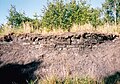
- Information board outcrop of coal seams
- Stockpile 21
- Bockwaer Valley
The mining nature trail has a length of about 2 km. The lowest point is on Schneeberger Straße at the Matthäuskirche with about 263 m above sea level. NHN , the highest point is station No. 12 with about 282 m above sea level.

No. 1 Matthäuskirche during the renovation

No. 2 overview board at the beginning of the Kohlenstraße

No. 3 steam mill shaft

No. 4 the water-filled sections of the Richard- and weather shaft form the weaver pond

No. 8 The saddle of the drainage shaft can still be seen

No. 9 official residence of the Steigers von Drescher's coal works (Behringstrasse 5)

No. 9 The site of Drescher's coal works, in the background the dump of the dewatering shaft

No. 13 embankment of the coal railway, view of Drescher's Steigerhaus

No. 14 The seams streaked out in this field
No. 15 Halde 21 served as an industrial sales facility (= sludge pond). The coal sludge was partly extracted and used as pond filter coal

No. 16 The Bockwaer Valley

The overflow of the water from the Bockwaer valley into the hollow


literature
- Arbeitskreis Steinkohle eV (= Steinkohlenbergbauverein Zwickau e.V.) (Ed.): Educational trail to Zwickau hard coal mining - Bockwaer Revier , Zwickau 1996 (leaflet)
- Author collective: The coal mining in the Zwickau area . Ed .: Steinkohlenbergbauverein Zwickau eV Förster & Borries, Zwickau 2000, ISBN 3-00-006207-6 .
- Sebastian Kolitsch: Hydrogeological analysis and large-scale modeling of the wider Vorerzgebirge basin . Ed .: Technical University Bergakademie Freiberg. Freiberg February 14, 2008 ( d-nb.info [PDF; 8.5 MB ; accessed on February 11, 2017] dissertation).
Individual evidence
- ↑ Steinkohlenbergbauverein Zwickau eV In: Sächsischer Landesverband der Bergmanns-, Hütten- und Knappenvereine eV bergbautradition-sachsen.de, accessed on January 7, 2017 .
- ↑ Second mining nature trail opened in Bockwa - buddies remember working underground . in: Freie Presse from September 9, 1996
- ↑ THW OV Zwickau: Technical relief organization rehearses for an emergency in the Bockwaer Senke. In: thw-zwickau.de. November 5, 2009. Retrieved February 11, 2017 .
- ^ Hans-Ullrich Besser: Contaminated sites in the urban area of Zwickau. (PDF; 5 MB) (No longer available online.) State Office for Environment and Geology Saxony, 2002, archived from the original on February 12, 2017 ; accessed on February 11, 2017 . Info: The archive link was inserted automatically and has not yet been checked. Please check the original and archive link according to the instructions and then remove this notice.
Web links
- Final report on project management floez 2007-2008. (PDF) September 30, 2008, pp. 19–32 , accessed January 7, 2017 .
Coordinates: 50 ° 41 ′ 48.4 " N , 12 ° 29 ′ 50.6" E