
Zwickau coal field

| |
Physical map of Saxony |

The Zwickau coal field is a former coal field in the south of Saxony . It originated in the Upper Carboniferous and formed 11 seams worth building with a total coal thickness of up to 32 m. From the 10th century to the end of mining in 1978, a total of around 230 million tons of hard coal was mined. It is one of the oldest hard coal mining areas in Germany. The Zwickau hard coal mining was first mentioned in a document in 1348 in the forging articles of the Zwickau town charter, when the blacksmiths were forbidden to work with hard coal within the city walls:
“There you sullet, that all smides who sit below the Mur, with no sullen smides with stone colons; who as often one understands as often has to give toes shillings lighter. "
Occasionally, the coal field is also conceptually combined with the neighboring Lugau-Oelsnitzer coal field to form the Zwickau-Oelsnitz coal field , but the two regions are separated from each other by a zone with no seams and differ both in geology and development history.
location
The Zwickau hard coal district extends about 11 km in an east-west direction and falls from Planitz in the southwest to Mülsen St. Niclas in the northeast. The dip is between 8 and 25 gon . The north-south extension in the direction of strike recedes by a maximum of 4 km. The western border is roughly formed by the Zwickau - Werdau railway line , the eastern border by the eastern edge of the Mülsengrund. The Zwickauer Mulde flows through the area from south to north.
geology

| Seam group | Seam designation | Type of coal | Mightiness |
|---|---|---|---|
| Upper seam group | Triple-cell seam | Pitch coal | 1-2 m |
| Three-and-a-half-cell seam | 1-2 m | ||
| Double-cell seam | 1-2 m | ||
| Shard coal seam | 1 m | ||
| Lehe coal seam | 1.5 m | ||
| Middle seam group | Zach coal seam | Pitch / soot coal | 2 m |
| Stratified coal seam | up to 4.5 m | ||
| Soot coal seam | up to 8 m | ||
| Deep Planitz seam | Pitch coal | 3–5 m | |
| Lower seam group | Ludwigflöz | Pitch / soot coal | more than 3 m |
| Blessing God seam | Carbon black | more than 6 m |
The district is located in the south-western part of the Erzgebirge basin . In the Carboniferous , more precisely in the Upper Carboniferous ( Westfal D ), a sedimentary basin formed as a result of the Variscan orogeny northwest of today's Ore Mountains , in which the dead plant remains of the coal forest could settle in the absence of air and were alternately overlaid by the erosion erosion of the Variscan Mountains ( coalification ). The lower part of the coal formation is formed by the basement, while the hanging wall consists of the red lying area and the tertiary and quaternary layers superimposed on it . Mainly slate and phyllite form the basement , followed by the max. 340 m thick coal mountains from the Upper Carboniferous. The rock layers in the seam mainly contain shale, as well as conglomerates and sandstones. There are a total of eleven minable seams in three groups with around 330 layers of coal. While the seams in the south of the Hammerwald and the Cainsdorfer Muldenbrücke reach the surface, the overburden on the northeastern edge of the deposit is approx. 1100–1200 m. In the north the seams are limited by the washing away and in the south and west they are rocky.
The coal formation strikes Herzynisch and falls Variscan.
Geological natural monument soot coal seam
The outcrop of the soot coal seam on the Mulde, the only permanently exposed outcrop of a coal seam in Saxony, is protected as a geological natural monument ( very rare in Central Europe as an outcrop from different geological ages ( Silurian , Devonian and Upper Carboniferous )) in accordance with Section 21 of the Saxon Nature Conservation Act (SächsNatSchG) .
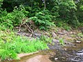
Soot coal seam, Zwickauer Mulde, left bank
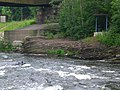
Soot coal seam, Zwickauer Mulde, right bank
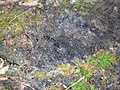
Soot coal seam, Zwickauer Mulde, left bank, detail


meaning
The Planitz coal deposits had been known since the 10th century and were used on a small scale for the extraction of forged and furnace coal until the beginning of industrialization . In the middle of the 18th century, the need for hard coal rose by leaps and bounds due to the triumphant advance of the steam engine and the development of the railway system . The Electorate and later Kingdom of Saxony was the most industrialized region in Germany at that time. The presence of indigenous hard coal enabled further advances in mechanical engineering and, in connection with the introduction of the freedom of trade in 1861, became the engine of a stormy development that was not achieved in the same proportion in any other German state. Major companies such as the Rich machine works. Hartmann, Chemnitz , the Zwickauer Maschinenfabrik, the Seilfabrik Zwickau, Friemann & Wolf Zwickau and the Königin-Marienhütte Cainsdorf; The Zwickau porcelain and ceramics industry, the Saxon vehicle industry, and indeed the entire Chemnitz – Zwickau industrial region, owe their origins to the Zwickau hard coal.
history
_b_444.jpg)

Hard coal mining was first documented in 1348, but hard coal has been used in the Zwickau area since the 10th century. The oldest use of coal to date within the city walls has been proven by archaeological investigations in the building of the old Zwickau Mint and is located around 1190. The early mining was facilitated by the stripping of the seams in the south and southwest of the area.
In 1474 there was a coal fire , presumably through spontaneous combustion, with the first Planitz earth fire , which could not be extinguished until 1490. During the Thirty Years' War , the Second Planitz earth fire in the soot-coal seam, which could not be fought successfully with the available means , is allegedly caused by Swedish arson . From 1837 to 1868 the botanist and chemist Ernst August Geitner set up the Geithner forge gardening facility on the Flur Am Hammerwald above the earth fire area, which used the heat of the burning Planitz coal seam. Geitner directed the warm emissions of the coal fires into greenhouses , in which he grew southern plants such as palm trees , orchids , cocoa plants , bamboo and banana plants . With the extinction of the coal fires, the time of gardening also ended . The last nests of fire were not finally extinguished until 1880.
From the 16th century onwards, after the near-surface supplies had been exhausted, more and more mining with small shafts and hand reels was used. Up until the 19th century there were no mining companies in the Zwickau district, the funding was provided by the Planitz manor and as a sideline by so-called "coal farmers" and day laborers. It was not until von Arnim - owner of the Planitz estate - that a modern mining company was founded in 1830 with the von Arnim coal works . The basis for this was the coal mandate of 1743, because before the coal mining was exclusively the property of the landowner, after that anyone could mine coal against compensation from the landowner. A further prerequisite was the row loading , abolished in 1823 , in which coal was sold according to a fixed sequence for each miner . Other large companies were established by 1868. Average production rose from around 2,900 tons of hard coal in the 18th century to over 2.5 million tons of hard coal per year at the beginning of the 20th century. This favored the development of Zwickau into an industrial city.
Initially, the mining fields west of the Zwickau Mulde formed the focus of mining, from the end of the 19th century this slowly shifted to the eastern part of the Zwickau hard coal mining area; mining west of the Mulde was discontinued in 1950. In the 1950s, the Mülsenfeld was explored, the mining field to the east in the Zwickau district. As the coal supply in the rest of the mining area was slowly running out, this mine field was the last to be opened with a calculated coal supply of over 35 million tons.
On September 29, 1978, the last hunt coal was mined from the Mülsenfeld, as the decision to gradually cease hard coal mining in the GDR was taken as early as 1967 . In total, around 242 million tons of hard coal were mined in the Zwickau mining area.
A successor industry was planned for the miners on or near the former mines. This affected the last three hard coal works in the area, the August-Bebel, the Karl-Marx and the Martin-Hoop works. In the August-Bebel-Werk on the left-hand side of the Mulde, after a shaft break in the company's main shaft, production was stopped on March 4, 1948, and since then only the coking plant has been operated there. When the Karl Marx plant was shut down around 1970, it was assigned to the Martin Hoop plant as an operating department on July 1, 1968 , and residual coal was mined from there via an underground conveyor connection. Most of the daytime facilities were demolished or rebuilt above ground and the steel construction industry, heating system construction and various smaller companies were established. Most of the miners were retrained and employed there. The coking plant and the power plant were assigned to the August-Bebel-Werk as operating parts and initially continued to operate (the coking plant until December 7, 1977, the power plant until December 23, 1998). After the closure of the Martin Hoop plant in 1978, it was now assigned to the August Bebel plant. Here, too, successor industries were settled for days, such as a precast concrete plant and an equipment manufacturer for the lignite industry, in which most of the miners found a new job.
The last economically used relic of hard coal mining was the Schedewitz coking plant, which was operated with imported hard coal until March 18, 1992.
Centuries of mining were also reflected in the streets of Zwickau. In addition to 52 streets , a bridge (the current Glückaufbrücke, which was newly built in the 1980s), on which the B 173 crosses the Mulde, was named with reference to mining. Until 1990 it was called Adolf-Hennecke-Brücke.
Heaps
The following heaps are located in this area:
| number | designation | Expansion in ha |
|---|---|---|
| 1 | At the coking plant and tar distillation, Brückenbergschacht I | 6.26 |
| 2 | At the Brückenbergschacht I | 4.35 |
| 3 | On Pöhlauer Straße, Brückenbergschacht III | 7.07 |
| 4th | On Pöhlauer Straße, Brückenbergschacht II | 7.23 |
| 5 | (no longer existent) | |
| 6th | At the Brückenbergschacht IV | 11.03 |
| 7th | (no longer existent) | |
| 8th | At the Morgensternschacht I | 9.6 |
| 9 | At the Morgensternschacht II | 1.63 |
| 10 | At the Morgensternschacht III | 11.18 |
| 11 | At the Martin-Hoop-Schacht V | 0.54 |
| 12 | (no longer existent) | |
| 13 | At the Kästnerschacht I. | 7.07 |
| 14th | At the Kästnerschacht II | 1.23 |
| 15th | At Wilhelm-Schacht I, to the west | 13.65 |
| 16 | At Wilhelm-Schacht I, north | 6.85 |
| 17th | Stockpile 3 at Wilhelmschacht II | 6.33 |
| 18th | Halde 2 at Wilhelmschacht II | 0.84 |
| 19th | Halde 1 at Wilhelmschacht II | 0.85 |
| 20th | At the von Arnim shafts | 11.73 |
| 21st | At the old community shafts | 12.9 |
| 22nd | At the August-Bebel-Werk, Malzinsel | 6.53 |
| 23 | At the forest and damage shaft | 13 |
| 24 | At the drainage shaft | 12.36 |
| 25th | (no longer existent) | |
| 26th | At the Westsachsenstadion, Vereinglückschacht | 7.16 |
| 27 | At the help of God shaft | 0.42 |
| 28 | At the Blessing God shaft | 2.35 |
| 29 | At Bürgererschacht I, to the west | 2.36 |
| 30th | At the new Alexanderschacht | 3.14 |
| 31 | At the Augustus shaft | 3.86 |
| 32 | At the Martin-Hoop-Schacht IV | 11.14 |
| 33 | At the Martin-Hoop-Schacht IX | 1.46 |
| 34 | At the Martin-Hoop-Schacht X | 0.95 |
| 35 | Halde Birkenweg | 0.09 |
| 36 | Halde Helmholtzstrasse | 0.89 |
| 37 | Halde Hofleite | 0.3 |
| 38 | Halde KGA garden friends / Halde 1 Oberhohndorf | 0.56 |
| 39 | Halde Comeniusweg / Halde 2 Oberhohndorf | 0.81 |
| 40 | Aurora shaft heap | 1.78 |
| 41 | Hope-Schacht-Halde | 0.08 |
| 42 | Sarfert shaft dump | 0.57 |
| 43 | Dump of the Ebert double shafts | 0.44 |
| 44 | Fortuna shaft dump | 0.59 |
| 45 | On Planitzer Strasse, Glückauf-Schacht | 1.81 |
| 46 | Halde at the Steigerhaus Fritscheschacht | 0.1 |
| 47 | Halde Schacht Altgemeinde Bockwa, Am Hammerwald | 1.32 |
| 48 | Dump site of the day 4 | 0.32 |
| 49 | Dump site of the day 2 | 0.52 |
| 50 | Halde des Communschachtes (No. 88) | 0.37 |
| 51 | Dump at the station shaft | 2.09 |
| 52 | Halde at Himmelsfürstschacht | 0.25 |
| 53 | Dump at Citizens' Shaft II | 1.61 |
| 54 | Halde Beschert-Glück-Schacht? | 0.36 |
| 55 | Halde west of Lindenstrasse | 0.57 |
| 56 | Halde at Bürgererschacht I, east | 1.22 |
| 57 | At Wilhelmschacht III | 0.8 |
| 58 | At the Drei-Fritzen-Schacht | 0.59 |
| 59 | Am Wilhelm Schacht I (east) | 2.86 |
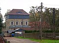
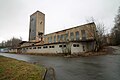
Preserved objects, monuments and museums of coal mining
- Reinsdorf Local History and Mining Museum :
In Reinsdorf near Zwickau, the winding tower of the "Morgensternschacht II" (clinker brick construction from 1902, shaft from 1872) could be saved from demolition. It was restored and is now run by an association as the Reinsdorf local history and mining museum. The list of monuments in Reinsdorf names the objects that have been preserved as follows: "Building of the former Morgenstern shaft II with winding tower, weather shaft, team building (No. 9) and forge (No. 11), expedition building, Obersteiger house (No. 15) and residential building (No. 15). 13) ".
From 1903 this headframe served as suction ventilation for the adjacent mine workings (e.g. Morgensternschacht III). Therefore, the headframe was built "closed". All windows and doors could be hermetically sealed. An axial fan created a negative pressure in the tower . At the same time, the tower was also used for driving and mining hard coal.
- Shafts IV and IVa of the Martin Hoop in Zwickau- Pöhlau
- “Martin Hoop V” greenhouse in Zwickau- Pöhlau
- Driving and machine house of the Brückenberg (Karl Marx) shaft IV, currently being used as the club house of the Zwickau Golf Club (Reinsdorfer Str. 29?)
- Headframe and hoisting machine building of the "Martin Hoop Shaft IX" in Mülsen St. Jacob
- Memorial to the Zwickau mine disaster in 1960 (on the Zwickau main cemetery)
- signposted "Mining educational trail Schedewitz - Oberhohndorf ", u. a. with embankment of the former Oberhohndorf-Reinsdorfer coal railway (closed in 1965) with remains of the foundation of the Muldenbrücke, house (residential building?) of the Hermannschachtes, "Bahnwärterhaus Hermannschacht", closed drainage tunnel, marked point of the "Frischglückschacht I", mining monument near the Schedewitz Muldenbrücke and several dumps.
- former mining school in Schedewitz (ruinous building)
- Railway line "Brückenbergschachtbahn" with "Stellwerk W3", Muldenbrücke (rivet construction) over Zwickauer Mulde (and Mulderadweg), track systems of the former Pöhlau freight station
- Administration and social building of Martin-Hoop-Schacht IX. in Mülsen St. Jacob with socialist wall frescoes
- obtained Waschkaue of Aurora shaft in Zwickau- Schedewitz
- two buildings of the former Fortuna shaft in Zwickau- Hinterneudörfel , u. a. "Gasthaus Malz"
- Former administration building of the Vereinglückschacht in Zwickau- Hinterneudörfel
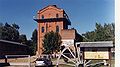
Headframe (1902) of the "Morgensternschacht II" in Reinsdorf, mining museum, 2005

Building of the "Morgensternschacht II" in 1999, before the restoration

"Karl-Marx-IV" greenhouse in Zwickau

Headframe Martin Hoop shafts IV (left) and IVa (right)
Greenhouse Martin Hoop V in Zwickau-Pöhlau
Headframe and hoisting machine building of the "Martin Hoop Shaft IX" in Mülsen St. Jacob

Embankment of the former Oberhohndorf-Reinsdorfer coal railway on the demolished Muldenbrücke
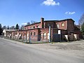
Former laundrette of the Aurora shaft in Zwickau-Schedewitz


literature
Historical representations
- Emil Herzog: History of the Zwickau hard coal industry. Verlag von Adler and Dietze, Dresden 1852.
- May, Stutzer, Eckardt: 75 years of joint work by the Saxon hard coal mines . Zwickau 1936.
- From the Brückenberg shafts to the VEB Steinkohlenwerk Karl Marx Zwickau 1859–1959. Collective of authors (business chronicle). Progress printer, Erfurt 1960.
- Mining around Zwickau: silver, coal, uranium - 1316, 1348, 1945. Löffler et al., Zwickau 2003, ISBN 3-933282-19-5 .
Reference books
- Fritz Heise , Friedrich Herbst , Carl Hellmut Fritzsche : Textbook of mining science with special consideration of hard coal mining . 8th edition. tape 1 . Springer-Verlag, Berlin 1942, p. 88, 89 (687 pp.).
- Coal mining in the Zwickau district. Zwickau Coal Mining Association e. V., Förster & Borries, Zwickau 2000, ISBN 3-00-006207-6 .
- Norbert Peschke : The Zwickau hard coal mining and its coal railways. Zschiesche GmbH, Wilkau-Haßlau 2007, ISBN 3-9808512-9-X .
- Klaus Hoth et al .: The Zwickau hard coal deposit . In: Saxon State Office for Environment, Agriculture and Geology [LfULG] (Hrsg.): Mining in Saxony . 1st edition. tape 15 . Druck- und Verlagsgesellschaft Marienberg mbH, Freiberg 2009, ISBN 978-3-9812792-1-4 (162 pp., Publications.sachsen.de ).
- The Zwickau hard coal industry . In: Louis Oeser (Ed.): Album of the Saxon Industry . tape 1 . Louis Oeser, Neusalza 1856, p. 101–112 ( full text [ Wikisource ]).
Fiction and Poetry

The miner and dialect poet Gustav Nötzold , who himself worked in the Revier between 1886 and 1918, gave great testimony to the hard fate and the joyful miner's poetry with his nine-volume Kuhlbröckle magazine . His work appeared in multiple editions between 1906 and 1939 and depicts the life of the Zwickau miners around 1900.
- Gustav Nötzold: Kuhlbröckle. Poems and stories in the Ore Mountains dialect . Self-published: Zwickau i. S., Heringsbrauerei , later Erzgebirgsverlag "Glückauf", Zwickau 1906–1939, each. Booklet approx. 80 pages
- Rudolf Fischer : Martin Hoop IV . Dietz, Berlin 1958 (The fire of 1952 was dealt with in this novel in 1955.).
- Thomas Klemm: The catastrophe of February 22nd, 1960. The novel about the mine disaster in the VEB coal works "Karl Marx" Zwickau . Grimma 2008 (260 pages).
- Günter Behnert: The shaft goat: miner's humor. True stories from the Zwickau coal mining area . Altis, Berlin 1999, ISBN 3-910195-22-9 .
- Günter Behnert: Coal mountain and women's ass . Altis, Friedrichsthal 2001, ISBN 3-910195-34-2 .
- Günter Behnert: The shaft goat's last mine trip . Altis, Friedrichsthal 2005, ISBN 3-910195-43-1 ( reading sample ).
- Zwickau and its coals . In: The Gazebo . Issue 32, 34, 37, 1857, pp. 442-445, 470-472, 506-508 ( full text [ Wikisource ]).
- Toni Pierenkemper: The industrialization of European mining regions in the 19th century . Franz Steiner Verlag, Stuttgart 2002, ISBN 3-515-07841-X , p. 103 ff . ( books.google.de - excerpt).
Web links
- Death in the shaft . ( Memento from November 2, 2003 in the Internet Archive ) MDR report
- Connecting railway
- Jürgen Ruder: The former coal mining districts of Zwickau and Lungau-Oelsnitz. An overview of the history of the geological and mining history of the former coal mining districts of Zwickau and Lungau-Oelsnitz. In: underground.com. (first published in bergbau 8/1998, pp. 367–380).
- Freiberg mountain archive
- Saxon Nature Conservation Act
- M. Felix, A. Sohr, P. Riedel, L. Assmann: Hazard potential of coal heaps Zwickau / Lugau-Oelsnitz - short report, Annex 1 (map of the heaps). (PDF) In: Hazard potential of the Zwickau / Oelsnitz coal dumps. October 16, 2009 .
Individual evidence
- ↑ May, Stutzer, Eckardt: 75 years of collaborative work by the Saxon hard coal mines. Zwickau 1936, p. 45.
- ↑ Michael Löffler, Norbert Peschke: Chronicle of the city of Zwickau. Förster & Borries, Zwickau 1993, ISBN 3-929354-07-1 , p. 285.
- ^ A b Silver, coal, uranium - mining around Zwickau. P. 16.
- ^ A b Silver, coal, uranium - mining around Zwickau. P. 17
- ↑ Geological outcrop of the soot coal seam 50 ° 41 ′ 10.26 ″ N , 12 ° 29 ′ 51.47 ″ E
- ↑ Ordinance of the district-free city of Zwickau on the establishment of the geological natural monument (# 5) "coal outcrop (carbon black seam)" on the bank of the Mulden at the Cainsdorfer bridge from January 27, 2000
- ↑ Dr. Hirzel: Mr. Fikentscher's chemical establishment in Zwickau . In: The Gazebo . Book 21, 1857, pp. 292-296 ( full text [ Wikisource ]).
- ↑ Michael Löffler, Norbert Peschke: Chronicle of the city of Zwickau. Förster & Borries, Zwickau 1993, ISBN 3-929354-07-1 , p. 21.
- ^ Frank Dörfelt: Zwickau's secret coin discovered. In: Freiepresse.de. Freie Presse, May 27, 2015, accessed on May 27, 2015 .
- ^ Silver, coal, uranium - mining around Zwickau. P. 52.
- ^ Silver, coal, uranium - mining around Zwickau. P. 16 f.
- ^ Silver, coal, uranium - mining around Zwickau. P. 18.
- ^ A b Silver, coal, uranium - mining around Zwickau. P. 20.
- ^ Silver, coal, uranium - mining around Zwickau. P. 22.
- ^ Silver, coal, uranium - mining around Zwickau. P. 53.
- ^ Silver, coal, uranium - mining around Zwickau. P. 23.
- ↑ Author collective: The coal mining in the Zwickau area . Ed .: Steinkohlenbergbauverein Zwickau e. V. Förster & Borries, Zwickau 2000, ISBN 3-00-006207-6 , p. 131, 134 .
- ↑ Author collective: The coal mining in the Zwickau area . Ed .: Steinkohlenbergbauverein Zwickau e. V. Förster & Borries, Zwickau 2000, ISBN 3-00-006207-6 , p. 149 .
- ↑ Author collective: The coal mining in the Zwickau area . Ed .: Steinkohlenbergbauverein Zwickau e. V. Förster & Borries, Zwickau 2000, ISBN 3-00-006207-6 , p. 151 .
- ↑ Author collective: The coal mining in the Zwickau area . Ed .: Steinkohlenbergbauverein Zwickau e. V. Förster & Borries, Zwickau 2000, ISBN 3-00-006207-6 , p. 485 .
- ^ Silver, coal, uranium - mining around Zwickau. P. 26.
- ↑ M. Felix, A. Sohr, P. Riedel, L. Assmann: Hazard potential Steinkohlenhalden Zwickau / Oelsnitz - short report, table 1. (PDF) In: Hazard potential Steinkohlenhalden Zwickau / Oelsnitz. October 16, 2009, accessed November 9, 2011 .
Coordinates: 50 ° 43 ′ 0.5 ″ N , 12 ° 30 ′ 39.7 ″ E