Wyspa Sobieszewska
| Wyspa Sobieszewska | ||
|---|---|---|
| Location of Wyspa Sobieszewska in the city of Gdańsk | ||
| Waters | Gdańsk Bay , Vistula | |
| Geographical location | 54 ° 19 '49 " N , 18 ° 52' 23" E | |
|
|
||
| length | 9.5 km | |
| width | 6 km | |
| surface | 35.79 km² | |
| Residents | 3443 96 inhabitants / km² |
|
| main place | Sobieszewo ( Bohnsack ) | |
The Wyspa Sobieszewska is an island on the Gulf of Gdansk in the Pomorskie in Poland . The current Polish name means Sobieszewsker Insel in translation , but in a figurative sense Bohnsacker Insel . Wyspa Sobieszewska is also the name of the easternmost district of Gdańsk .
The island is about 15 km east of the city center of Gdańsk . 3443 people live on the island.
The area got its current Polish name after the main town Sobieszewo ( Bohnsack ) , a former fishing village in the west of the island. Other settlements are Sobieszewko (Bohnsacker Pfarrdorf), Sobieszewska Pastwa (Bohnsackerweide), Przegalina (deposit), Wieniec (Kronenhof), Górki Wschodnie (Ostlich-Neufähr), Komary (Schnakenburg), Świbno ( Schlinkenhorst ) and Orel . Since December 1, 1973, all places have been administratively part of the city of Gdansk.
history
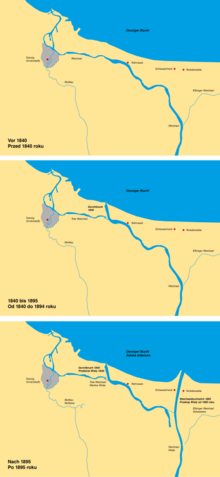
Today's island was formerly part of the Gdansk Spit , in Gdansk mostly just referred to as the Spit . This narrow strip of dunes was extended to include the outer miter through land reclamation measures . When this low area, which was often flooded, was diked towards the Vistula , the name was changed to New Inner Spit in the 19th century . This happened in contrast to the old inland spit near Steegen , which received its dike earlier . The border dike to the external honoring ran approximately east of the current river Weichsel.
geography
Size and location
The 35.79 km² island is bordered in the north by the Baltic Sea and on all other sides by the arms of the Vistula Delta. The island was the end of January 1840 after a flood that led to the dunes breakthrough on the southwestern shore and 1895, after the Vistula by an artificial puncture their current direct outflow ( current Vistula was made possible) in the Baltic Sea. The island borders in the west on Wyspa Portowa ( harbor island ).
Inland waters and nature reserve
At Górki Wschodnie, on the north-western tip of the island, there is the 198 hectare Ptasi Raj nature reserve with the two lakes Jezioro Ptasi Raj and Jezioro Karaś.
traffic
Voivodeship Road 501 runs across the island in a west-east direction . In the west of the island there is a pontoon bridge over the arm of the river known today as Martwa Wisła ( Dead Vistula ), in the east there is a ferry connection from Świbno (Schiewenhorst) to Mikoszewo (Nickelswalde) over the main arm of the Vistula, in the south you can get to Przegalina (insert) Cross the Strom Weichsel / Dead Weichsel lock via a bascule bridge built in 2012.
Until 1974 a line of the narrow-gauge former West Prussian small railway (Żuławska Kolej Dojazdowa) crossed the spit. The connection to the east across the Vistula to still existing rest rail network happened to 1956 via Trajektbetrieb on a steam ferry between Świbno (Schiewenhorst) and Mikoszewo (Nickelswalde) . From 1956 to 1974 there was a separate island traffic, which was discontinued in 1974. The railway systems were dismantled.
Individual evidence
- ↑ Podział administracyjny Gdańska - Gdańsk - oficjalna strona miasta - Official website of the City of Gdańsk. As of January 12, 2011. Accessed January 17, 2012
- ↑ Podział administracyjny Gdańska - Gdańsk - oficjalna strona miasta - Official website of the City of Gdańsk. As of January 12, 2011. Accessed January 17, 2012


