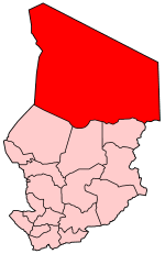
Borkou-Ennedi-Tibesti
| Borkou-Ennedi-Tibesti | |
|---|---|
 |
|
| Basic data | |
| Country | Chad |
| Capital | Faya-Largeau |
| surface | 600,350 km² |
| Residents | 103,000 (calculation 2007) |
| density | 0.2 inhabitants per km² |
| ISO 3166-2 | TD |
Coordinates: 18 ° N , 19 ° E
Until 2008, Borkou-Ennedi-Tibesti was one of the then 18 regions of Chad with around 103,000 inhabitants and corresponded to the former prefecture of the same name. Their capital was Faya-Largeau . In 2008 the territory of the region was divided into the newly created regions of Borkou , Ennedi and Tibesti .
geography
With 600,350 km², Borkou-Ennedi-Tibesti was by far the largest of the 18 regions of Chad. It included the northern part of the country.
Borkou-Ennedi-Tibesti was mainly in the Sahara and partly in the Sahel zone . In the region are the Bodele-Djourab lowlands , in the east the Ennedi massif , in the northeast the Mourdi depression and Erdiland and in the north the Tibesti mountain range.
In the north, the region was bounded by the Aouzou strip , which was also the border with Libya . In the west, Borkou-Ennedi-Tibesti bordered the Niger and in the east on the Darfur region in Sudan .
Breakdown
Borkou-Ennedi-Tibesti was divided into four departments ( départements ):
| department | main place | Sub-prefectures |
|---|---|---|
| Borkou | Faya-Largeau | Borkou Yala, Faya-Largeau, Kouba Olanga, Yebibou, Yarda |
| Ennedi Est | Bahaï | Bahaï, Bao Billiat, Kaoura, Mourdi |
| Ennedi Ouest | Fada | Fada, Gouro, Kalait, Ounianga |
| Tibesti | Bardaï | Aouzou, Bardaï, Wour, Zouar, Zoumri |
Borkou-Ennedi-Tibesti had the ISO 3166-2 code TD-BET until June 30, 2010 . According to the new division, the ISO code TD-BET has been omitted. The ISO codes TD-BO for Borkou, TD-EN for Ennedi and TD-TI for Tibesti now apply to the regions of the territory.
population

The Daza ( Tubu ) made up over half of the population in Borkou-Ennedi-Tibesti. Other ethnic groups were the Teda (also Tubu), Zaghawa and Chadian Arabs.
Overall, the region was sparsely populated.
history
The area ruled by Libyan Sanussiya in the second half of the 19th century came under French colonial rule until 1907. The French limit themselves to a largely indirect exercise of power in the sparsely populated area and left the Aouzou strip bordering Italian Libya to fascist Italy in 1934 / 35–1943 / 47 . With independence in 1960, the region became part of Chad, but in the shadow of the Chad Civil War , Libya annexed the Aouzou Strip again in 1973–1987 and 1988–1994 and supported the counter-government of GUNT President Goukouni Oueddei , who resided in Bardai . Until 1986 Oueddeis GUNT and Libyan troops controlled the entire Borkou-Ennedi-Tibesti area and thus over a third of Chad.
Individual evidence
- ↑ bevölkerungsstatistik.de (2007)
- ↑ ISO 3166-2 Newsletter (PDF; 537 kB) of the International Organization for Standardization , accessed on June 20, 2011