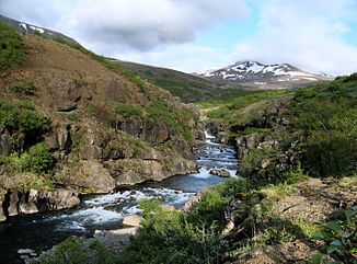
Botnsá
| Botnsá | ||
| Data | ||
| location | Vesturland ( Iceland ) | |
| source | Outflow from the Hvalvatn 64 ° 23 ′ 47 ″ N , 21 ° 11 ′ 57 ″ W. |
|
| Source height | 378 m | |
| muzzle | Botnsvogur / Hvalfjörður Coordinates: 64 ° 23 '2 " N , 21 ° 21' 25" W 64 ° 23 '2 " N , 21 ° 21' 25" W. |
|
| Mouth height | 0 m | |
| Height difference | 378 m | |
| Bottom slope | 42 ‰ | |
| length | 9 km | |
| Left tributaries | Hvalskarðsá | |
| Communities | Hvalfjarðarsveit | |
| Waterfalls: Glymur | ||
The Botnsá is a river in western Iceland in the municipality of Hvalfjarðarsveit .
River course
The Botnsá forms the outflow of the Hvalvatns , it flows north of the Hvalfell . Here it falls 196 meters over the Glymur , the second highest waterfall in the country. Continue through the uninhabited Botnsdalur to Botnsvogur Bay, the easternmost part of Hvalfjörður . Just before the mouth of the river, Hvalfjarðarvegur ![]() is the only road that crosses this river.
is the only road that crosses this river.
Web links
- Botnsá at NAT.IS (Icelandic)
