Brecon Beacons
| Brecon Beacons | ||
|---|---|---|
|
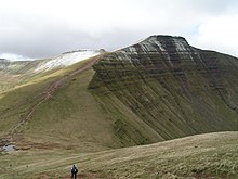
View from the 886 meter high Pen y Fan to the 795 meter high Cribyn |
||
| Highest peak | Pen y Fan ( 886 m ASL ) | |
| location | Wales | |
|
|
||
| Coordinates | 51 ° 53 ′ N , 3 ° 26 ′ W | |
| surface | 1,344 km² | |
The Brecon Beacons ( Welsh : Bannau Brycheiniog ) are a mountain range in southeast Wales . The name comes from the medieval tradition of beacons on the mountain peaks as a warning against attacks by the British.
location
The Brecon Beacons include the mountains in the south of Brecon with the Pen y Fan (886 m), the Corn Du (873 m), the Cribyn (795 m) and the Fan y Bîg (719 m). These peaks form a horseshoe-shaped mountain range around the delta of the Taf Fechan River in the southeast, as well as elongated parallel spurs towards the northeast. The Taf-Fechan panorama is also called the beacons horseshoe .
National park
The mountain range forms the core of the Brecon Beacons National Park (Welsh: Parc Cenedlaethol Bannau Brycheiniog ), one of three national parks in Wales.
The national park was established in 1957 as the last of the three Welsh parks. At 1,344 square kilometers, it covers significantly more land than just the Brecon Beacons themselves. It extends from Llandeilo in the west to Hay-on-Wye in the east. It also includes the Black Mountains in the east of the park on the border with England and Black Mountain in the west. The area west of the Brecon Beacons is Fforest Fawr or Great Forest called and was in 2005 by the UNESCO as a Geopark excellent. The park is also known for its waterfalls such as the Henrhyd , which plunges 27 meters into the depth, or the Ystradfelly Falls and their cave systems such as Ogof Ffynnon Ddu .
Most of the national park consists of moorland interspersed with forestry and pasture land. Popular recreational activities in the park include hiking, biking, horse riding, sailing, windsurfing, canoeing, fishing, climbing and caving. On May 22, 2005, the first full-length hiking trail was opened. It runs 100 miles from Abergavenny past Crickhowell and ends in Bethlehem, Carmarthenshire . On its way from Brecon to Cardiff also leads Taff Trail through the Beacons.
Due to their remoteness, parts of the park are used as training areas for units of the British Army. So z. As the Special Forces Special Air Service (SAS), both part of their selection process Selection and challenging exercises and marches in the Brecon Beacons through.
Villages and settlements
- Abercrave, Aberdare, Abergavenny , Ammanford
- Brecon , Brynmawr
- Crickhowell
- Glynneath
- Hay on Wye, Hirwaun
- Felinfach
- Llandovery , Llangadog, Llanwrtyd Wells
- Pontypool , Pontypridd
- Sennybridge
- Talgarth, Tredegar
- Ystradgynlai

