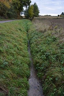
Breniger Mühlenbach
|
Breniger Mühlenbach Breniger Bach, Mühlbach, Mühlenbach |
||
|
south of Brenig |
||
| Data | ||
| Water code | DE : 2731212 | |
| location |
Foothills (Rhineland)
|
|
| River system | Rhine | |
| Drain over | Alfterer Bornheimer Bach → Rhine → North Sea | |
| source | south of Brenig 50 ° 44 ′ 46 ″ N , 6 ° 58 ′ 15 ″ E |
|
| Source height | approx. 135 m above sea level NHN | |
| muzzle | southwest of Eichenkamp Coordinates: 50 ° 46 ′ 21 ″ N , 6 ° 59 ′ 42 ″ E 50 ° 46 ′ 21 ″ N , 6 ° 59 ′ 42 ″ E |
|
| Mouth height | approx. 51 m above sea level NHN | |
| Height difference | approx. 84 m | |
| Bottom slope | approx. 22 ‰ | |
| length | 3.9 km | |
| Reservoirs flowed through | Reservoir south of Brenig | |
| Medium-sized cities | Bornheim | |
|
Reservoir at the NSG Mühlbachtal |
||
The Breniger Mühlenbach is a left and western tributary of the Alfterer Bornheimer Bach.
course
The stream rises about one kilometer south of the Bornheim district of Brenig in the Mühlbachtal nature reserve . The source is at an altitude of 135 m above sea level. NHN . Mainly flowing to the north, the brook Brenig passes and reaches the town center of Bornheim, through which it flows in pipes. Outside the town center, it continues to flow openly and flows one kilometer north of the city near the “Eichenkamp” into the Rhine inflow Alfterer Bornheimer Bach.
Web links
- Breniger Mühlenbach in the specialist information system ELWAS, Ministry for Climate Protection, Environment, Agriculture, Nature and Consumer Protection North Rhine-Westphalia ( information )
Individual evidence
- ↑ a b German basic map 1: 5000
- ↑ Water directory of the State Office for Nature, Environment and Consumer Protection NRW 2010 (XLS; 4.67 MB) ( Notes )
- ^ "Mühlbachtal" nature reserve in the specialist information system of the State Office for Nature, Environment and Consumer Protection in North Rhine-Westphalia

