Alfter Bornheimer Bach
|
Alfterer Bornheimer Bach Mirbach , Görresbach , Roisdorfer Bornheimer Bach |
||
|
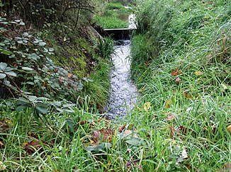
Alfterer Bornheimer Bach (Görresbach) in Alfter |
||
| Data | ||
| Water code | DE : 27312 | |
| location |
Lower Rhine Bay
|
|
| River system | Rhine | |
| Drain over | Rhine → North Sea | |
| source | South of Alfter 50 ° 43 ′ 17 ″ N , 7 ° 0 ′ 29 ″ E |
|
| Source height | 158 m above sea level NHN | |
| muzzle | In Bornheim - Widdig in the Rhine coordinates: 50 ° 47 '53 " N , 7 ° 1' 38" O 50 ° 47 '53 " N , 7 ° 1' 38" O |
|
| Mouth height | 47 m above sea level NHN | |
| Height difference | 111 m | |
| Bottom slope | 9.9 ‰ | |
| length | 11.2 km | |
| Catchment area | 37.6 km² | |
| Left tributaries | Wolfsbach , Breniger Mühlenbach | |
| Medium-sized cities | Bornheim (Rhineland) | |
| Communities | Alfter | |
|
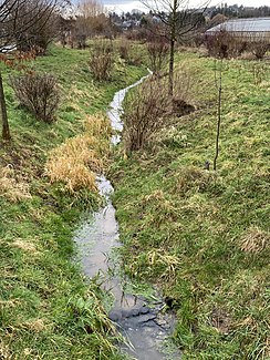
Alfterer Bornheimer Bach (Mirbach) in Alfter |
||
|
Alfterer Bornheimer Bach (Roisdorfer Bornheimer Bach) |
||
The Alfterer Bornheimer Bach is an 11.2 km long, orographically left tributary of the Rhine in North Rhine-Westphalia , Germany .
Surname
The name Alfterer Bornheimer Bach is an artificial product that was created in 2008 to make clear the responsibility of the water association Südliches Vorgebirge for the Alfter area as well. So far it has not been able to prevail on site. The sections of the stream are called Mirbach (11.2–9.4 km), Görresbach (9.4–7.5 km) and Roisdorfer Bornheimer Bach (7.5–0 km). These names are also used on site. When the Alfterer Mühle (Kronenstrasse) was still in operation, the creek was simply called Mühlenbach , this name is still in use among older residents in Alfter.
geography
The Alfterer Bornheimer Bach rises as Mirbach south of Alfter on the border with the district of Gielsdorf at an altitude of 158 m above sea level. NHN . From here the stream flows to the northeast and after a short run reaches the southern outskirts of Alfter. Here it is piped and joins underground with the Görresbach coming from Broich Park . As Görresbach it flows through another part of Alfter, in order - again piped - to continue its course underground to the local border of Alfter. As Roisdorf Bornheimer Bach it flows through Bornheim. At 6.4 km in the Roisdorf district , the Wolfsbach flows into the Alfterer Bornheimer Bach, at 4.4 km the Breniger Mühlenbach . The Alfterer Bornheimer Bach flows into the district of Widdig at an altitude of 47 m above sea level. NHN at Rhine km 664.2 into the Rhine.
On its 11.2 km long path, the stream experiences a height difference of 111 meters, which corresponds to a mean bed gradient of 9.9 ‰. The 37.6 km² catchment area drains over the Rhine to the North Sea . The most important tributary is the Breniger Mühlenbach with a length of 3.8 km.
The Alfterer Bornheimer Bach (formerly Roisdorfer Bornheimer Bach) used to seep into the fields below Bornheim until it was drained into the Rhine with 1.8 km of piping in the early 1930s.
Flood
| The Alfterer Bornheimer Bach and the surrounding area are among the flood areas designated by the Cologne District Government. There was an exceptional flood in July 2009 when the Görresbach section overflowed its banks.
A relief ditch was therefore built to reduce the risk of flooding by absorbing surface water at an early stage and feeding it to the lower reaches of the Görresbach (near the border with Bornheim). |
Web links
Individual evidence
- ^ Ewald Glässer: Geographical land survey: The natural space units on sheet 122/123 Cologne / Aachen. Federal Institute for Regional Studies, Bad Godesberg 1978. → Online map (PDF; 8.7 MB)
- ↑ a b German basic map 1: 5000
- ↑ a b c d Water directory of the State Office for Nature, Environment and Consumer Protection NRW 2010 (XLS; 4.67 MB) ( Notes )
- ↑ Ilse Mohr: Wasserverband Südliches Vorgebirge - 35 kilometers of waterway in view. In: General-Anzeiger (Bonn). July 8, 2015, accessed April 29, 2019 .
- ^ Wasserverband Südliches Vorgebirge ( Memento from August 19, 2013 in the Internet Archive ), accessed on March 21, 2014.
- ↑ Rheingraben sub- catchment area. (No longer available online.) Cologne District Government, archived from the original on December 3, 2013 ; Retrieved December 8, 2013 .
- ^ Ilse Mohr: Relief ditch in Alfter. Most of the gutter has already been sown with lawn. In: General-Anzeiger (Bonn). March 20, 2014, accessed March 21, 2014 .
- ^ Ilse Mohr: Relief ditch in Alfter. Protection from the masses of water. In: General-Anzeiger (Bonn). July 28, 2014, accessed July 30, 2014 .
- ↑ Specialized information system ELWAS, Ministry for Climate Protection, Environment, Agriculture, Nature and Consumer Protection NRW ( information )


