Board fork
| Board fork | ||
|---|---|---|
|
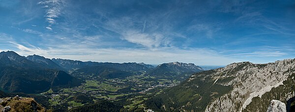
The board fork in the center of the picture. In the foreground the north-western ridge. In the background the Berchtesgaden valley basin. |
||
| height | 1805 m | |
| location | Bavaria , Germany | |
| Mountains | Göllstock , Berchtesgaden Alps | |
| Coordinates | 47 ° 35 '28 " N , 13 ° 1' 58" E | |
|
|
||
The 1805.2 meter high board fork forms a striking vantage point at the end of the north-western ridge of the Hohe Brett . It drops steeply over 500 meters on two flanks. On the fork there is a wooden summit cross with a summit book and a trigonometric measuring point. Due to the exposed location, you have an extensive panoramic view of the Berchtesgaden valley basin. The view extends from the Hagengebirge over the Steinerne Meer with the Schönfeldspitze and the Großer Hundstod to the Untersberg and the Kehlsteinhaus . Parts of the Königsee lake , which is about 1200 meters below , can also be seen.
Since autumn 2010, one of the eight transmission systems has been located just above the fork, which serve as pseudolites in the GALILEO test and development environment (GATE) of the European satellite navigation system Galileo to simulate navigation satellites.
The Brettgabel can only be reached from the valley via an unofficial, unmarked, often steep or stony path from the Hinterbrand car park, which is not shown on many maps . This path branches off unsigned about 50 meters after the barrier on the forest path in the direction of Jenneralmen into the forest, then leads over an alpine meadow and subsequent rubble and rocky terrain to the Brettgabel. Allow around two hours for the ascent. Surefootedness is required, and a few short climbing sections of the first degree of difficulty have to be mastered. If you follow the beaten path at a junction just before the lookout point further south, you will climb the Hohe Brett in about two hours. The board fork can be linked to tours on the Hohe Göll or the Hohe Brett.
Sources and literature
- ↑ Alpine Association Map Bavarian Alps, sheet BY 21. 1: 25000, Deutscher Alpenverein (Ed.), State Office for Surveying a. Geoinformation Bavaria, Munich 2010, ISBN 978-3-937530-46-8 .
- ↑ Bernhard Kühnhauser: Alpine Club Guide Berchtesgaden Alps with Hochkönig . 20th edition. Bergverlag Rother , Munich 2011, ISBN 978-3-7633-1127-9 . P. 514, paragraph 2730.
- ^ Report in the Berchtesgadener Anzeiger from September 1, 2010 on the expansion of the GATE
- ^ Brandl, Sepp: Berchtesgadener and Chiemgauer hiking mountains . Munich 2003, ISBN 3-7633-3021-6 .
- ↑ Summit book: Brettgabel - Hohes Brett ( Memento from December 16, 2005 in the Internet Archive )
- ↑ Tour description on the Kreuzgipfel.de website, accessed on October 4, 2012


