Brookwood, Alabama
| Brookwood | |
|---|---|
|
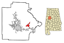
Location in county and state
|
|
| Basic data | |
| State : | United States |
| State : | Alabama |
| County : | Tuscaloosa County |
| Coordinates : | 33 ° 14 ′ N , 87 ° 19 ′ W |
| Time zone : | Central ( UTC − 6 / −5 ) |
| Residents : | 1,828 (as of 2010) |
| Population density : | 86.6 inhabitants per km 2 |
| Area : | 21.2 km 2 (approx. 8 mi 2 ) of which 21.1 km 2 (approx. 8 mi 2 ) is land |
| Height : | 183 m |
| Postal code : | 35444 |
| Area code : | +1 205 |
| FIPS : | 01-09808 |
| GNIS ID : | 0114971 |
| Website : | www.brookwoodalabama.com |
Brookwood is a city in Tuscaloosa County in the US state of Alabama with a total area of 21.2 km². In 2010 Brookwood had 1,828 residents.
geography
Brookwood is located in western Alabama in the southern United States.
Nearby places include Vance (1 km southeast), Coaling (2 km southwest), Tuscaloosa (6 km west), Woodstock (7 km east) and Holt (8 km west).
history
When the first settlers softened the area, it was still known as Horsehead . The first mines were opened in 1889, followed by a post office in 1890. Four settlements sprang up around the mines: East Brookwood , Central Brookwood , West Brookwood, and Kellerman . Today's Brookwood developed from these settlements, and the construction of a railway line brought more businesses and residents to the town. Almost 2500 people lived here around 1900.
In 1977 the city was incorporated. In 2001, a roof collapse and several explosions killed 13 miners, including some from Brookwood.
traffic
Alabama State Route 216 runs through the north of the city , along the southern part of the city on a shared route also Interstate 20 and Interstate 59 and 2 kilometers south of US Highway 11 .
The Tuscaloosa Regional Airport is located about 21 kilometers to the west .
Demographics
As of the 2000 census , Brookwood had 1,483 residents, distributed among 553 households and 430 families. The population density was 70.4 inhabitants / km². 97.91% of the population were white and 0.54% were African American. Children under the age of 18 lived in 42.1% of households. The median income was $ 40,104 and 8.2% of the population is below the poverty line .
By the 2010 census , the population rose to 1,828.
Web links
- Official website (English)
- Statistical data on Brookwood (English)
- Brookwood in the Encyclopedia of Alabama (English)
