
Brunnenkogelhaus
| Brunnenkogelhaus ÖTK hut |
||
|---|---|---|
 Brunnenkogelhaus |
||
| Mountain range | Stubai Alps | |
| Geographical location: | 46 ° 56 '50.6 " N , 11 ° 2' 55.4" E | |
| Altitude | 2738 m above sea level A. | |
|
||
| owner | ÖTK (main association) | |
| Built | 2007 | |
| Construction type | Hut; Wood | |
| Usual opening times | Mid-June to the last weekend in September | |
| accommodation | 12 beds, 12 camps | |
| Winter room | No | |
| Web link | Homepage of the tenant | |
| Hut directory | ÖTK ÖAV DAV | |

The Brunnenkogelhaus is a refuge of the Austrian Tourist Club (ÖTK) in the Stubai Alps . It is located at an altitude of 2738 m on the last summit at the end of the Brunnenkogel ridge (also called Windachkamm) the southwest ridge of the Wannenkogel ( 3089 m ). The ridge runs between the Windachtal in the north, the Timmelstal in the south and the transition from the Gurgler Tal to the Ötztal in the southwest. The hut belongs to the municipality of Sölden . It is in an exposed location and can be seen from afar from the surrounding peaks and also from the Ötztal. Due to their location, there is a wide panoramic view of the peaks of the Ötztal and Stubai Alps, as well as the Ötztal, the Venter Tal and the Gurgler Tal.
history
The first stone building was built in 1887. Due to dilapidation, this was replaced by a new, modern wooden hut in 2007.
Entrances and transitions
The direct ascent to the hut in Sölden / Moos can be done in 3.5 hours. An indirect access initially runs through the Windachtal via the Gasthaus Fiegl ( 1956 m ), after which the path branches off to the Brunnenkogelhaus. 4 hours must be planned for this variant. The hut can also be reached from Zwieselstein ( 1472 m ) in 4 hours. An interesting access variant is the Hochstubai-Panoramaweg (Archduke Eugen-Steig) over the ridge starting from Timmelsjoch in 5 hours. Crossings to neighboring huts are possible to the Hildesheimer Hütte ( 2900 m ) in 4 hours, to the Hochstubaihütte ( 3174 m ) in 4.5 hours and to the Siegerlandhütte ( 2710 m ) in 4.25 hours.
Mountaineering
You can reach the summit of the Brunnenkogelgrat to Wannenkogel via the Hochstubai-Panoramaweg in the order Vorderer Brunnenkogel ( 2761 m ) in 0.25 h, Hinterer Brunnenkogel ( 2775 m ) in 1 h, Rotkogel ( 2894 m ) in 1.25 h and Wilde Rötespitze ( 2966 m ) can be reached in 2.5 hours. From the Wannenkarsattel ( 2916 m ) you can continue to climb the ridge of the Wannenkogel ( 3089 m ) on an unmarked path .
Picture gallery

Brunnenkogelhaus

Brunnenkogelhaus

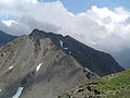
Rotkogel 2894 m north side

Rotkogel 2894 m south side
Wilde Rötespitze 2966 m north side

Wilde Rötespitze 2966 m south side
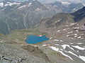
Wannenkarsee


literature
- Henriette and Walter Klier: Ötztal - Ötztal Alps - Stubai Alps -, Rother hiking guides. 4th edition. Bergverlag Rother , Munich 2007, ISBN 978-3-7633-4094-1 .
- Kompass hiking map 42 Inner Ötztal - Gurgler Tal, Venter Tal, Pitztal. 1: 25000, ISBN 3-85491-600-0 .
- Compass hiking map 43 Ötztal Alps - Ötztal, Pitztal. 1: 50000, ISBN 978-3-85491-049-7 .
Web links
Individual evidence
- ^ Henriette and Walter Klier: Ötztal - Ötztal Alps - Stubai Alps -, Rother hiking guide. 4th edition. Bergverlag Rother , Munich 2007, ISBN 978-3-7633-4094-1 .