Brunsbach (Sülz)
|
Brunsbach Brünsbach, Knipperbach (lower stretch of water) |
||
|
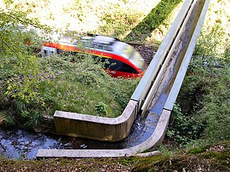
Brunsbach (bridge over the Cologne – Gummersbach railway) |
||
| Data | ||
| Water code | DE : 2728892 | |
| location | Germany | |
| River system | Rhine | |
| Drain over | Sülz → Agger → Sieg → Rhine → North Sea | |
| source | west of Breide 50 ° 55 ′ 23 ″ N , 7 ° 13 ′ 55 ″ E |
|
| Source height | 213 m above sea level NHN | |
| muzzle | at Hopesthal in the Sülz coordinates: 50 ° 54 '52 " N , 7 ° 11' 45" E 50 ° 54 '52 " N , 7 ° 11' 45" E |
|
| Mouth height | 82 m above sea level NHN | |
| Height difference | 131 m | |
| Bottom slope | 38 ‰ | |
| length | 3.4 km | |
| Catchment area | 4.253 km² | |
| Discharge A Eo : 4.253 km² at the mouth |
MNQ MQ Mq |
4.54 l / s 59.94 l / s 14.1 l / (s km²) |
The Brunsbach or Brünsbach is an approx. 3.4 km long, left tributary of the Sülz in the Rheinisch-Bergisches Kreis in North Rhine-Westphalia ( Germany ).
geography
course
The stream rises west of Breide, roughly in the middle between Bleifeld and Durbusch in the Rösrath urban area. In the lower course of the river section name is "Knipperbach". After 1.665 km, the Knipperbach flows into the Sülz at Hopesthal .
Knipperbach river system
The information is z. Partly contradicting, here a representation according to ELWAS water body name GSK3C with length information in km, catchment area size in km² and discharge values ( MQ ) in liters / second (l / s):
Knipperbach 1.7 km (with Brunsbach 3.4 km), 4.3 km², 59.9 l / s
- Brunsbach ( right source stream , main line ), 1.7 km, 1.3 km², 20 l / s
- Durbuscher Bach ( left ), 0.8 km, 0.3 km², 4 l / s
- Bleifelder Bach ( left source brook , branch line ), 1.8 km, 0.9 km², 14 l / s
- Brunsbach [sic] ( left ), 1.7 km, 0.8 km², 11 l / s
- Stöckersiefen ( left ), 0.4 km, 0.1 km², 1.4 l / s
- Wesselssiefen ( left ), 0.3 km
- Hofferhofer Bach ( left ), 1.5 km, 0.6 km², 7.5 l / s
The bridge
The stream is routed about 150 meters in front of the railway tunnel between Hopesthal and Honrath by means of a bridge over the Cologne – Gummersbach railway line. In the further course the brook changes three times underground to the other side of the railway line.
The creek in the area of the Hopesthal outdoor pool
When the open-air swimming pool in Hopesthal was set up in 1937 to promote tourism, the water was fed by the Knipperbach. Filter systems ensured that the polluted water of the stream was cleaned. With the renovation of the baths in 1966, the stream water was replaced by drinking water. Since then, the Knipperbach has been piped under the swimming pool and the Rotdornallee to the main street in Hoffnungsthal. On the other side of the main road, the stream flows above ground again, past the old mayor's office and flows into the Sülz at the Sülzbrücke.
literature
- Caesarius Volberg: Dat Bröckelche - Rösroder Verzäll vun däm Knipperbach singem Bröckelche over de Ieserbahn. Dialect contribution in: Rheinisch Bergischer Calendar 2010. Yearbook for the Bergisches Land, Bergisch Gladbach 2009, ISBN 978-3-87314-444-6 , p. 64.
- Peter Wieners: Structural developments in the Hopesthal outdoor pool from 1945. In: A community goes swimming - 50 years of the Hopesthal outdoor pool. In: Series of publications by the history association for the community of Rösrath and the surrounding area. V. Volume 18, Rösrath 1987, pp. 58-64.
Web links
References and comments
- ↑ a b German basic map 1: 5000
- ↑ a b Topographical Information Management, Cologne District Government, Department GEObasis NRW ( Notes )
- ↑ Modeled discharge values according to the specialist information system ELWAS, Ministry for Climate Protection, Environment, Agriculture, Nature and Consumer Protection NRW ( notes )
- ↑ Water directory of the State Office for Nature, Environment and Consumer Protection NRW 2010 (XLS; 4.67 MB) ( Notes )
- ↑ from the confluence of its source streams
- ↑ In ELWAS: Main name Knipper Bach and section name Brunsbach
- ↑ sometimes also Brünsbach
- ↑ Self-measurement on ELWAS
