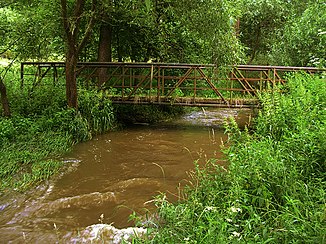
Brzina
| Brzina | ||
|
The Brzina at the bridge at Smetákův Mlýn |
||
| Data | ||
| Water code | CZ : 1-08-05-026 | |
| location | Czech Republic | |
| River system | Elbe | |
| Drain over | Vltava → Elbe → North Sea | |
| source | southeast of Hrazánky in the Votická pahorkatina 49 ° 30 ′ 40 ″ N , 14 ° 20 ′ 38 ″ E |
|
| Source height | 541 m nm | |
| muzzle | opposite Hřiměždice in the Slapy reservoir Coordinates: 49 ° 40 ′ 38 ″ N , 14 ° 17 ′ 21 ″ E 49 ° 40 ′ 38 ″ N , 14 ° 17 ′ 21 ″ E |
|
| Mouth height | 271 m nm | |
| Height difference | 270 m | |
| Bottom slope | 9.9 ‰ | |
| length | 27.3 km | |
| Catchment area | 141 km² | |
| Drain |
MQ |
450 l / s |
The Brzina is a right tributary of the Vltava in the Czech Republic .
course
The Brzina rises 700 m southeast of the village Hrazánky in the Votická pahorkatina ( Wotitzer hill country ) belonging to the Central Bohemian hill country . Its upper course initially runs a short distance to the east, but then takes a northerly direction. Past Kozín, Hrazánky, Hněvanice, Hrazany and Šumava, the Brzina forms a shallow valley and reaches the Petrovicko Nature Park near Mašov. Along the stream follow the places Kolárna, Porešín, Kojetín, Petrovice , Vilasova Lhota and Petrovický Mlýn, where the Brzina leaves the nature park again at the confluence of the Kněžský potok. On the following section, the stream flows north-westerly past Kulišov, Ovčín, Skoupý, Melena, Kuní, Sadka, U Petříčků, Týnčany, Radašův Mlýn, Mikův Mlýn and Krašovice through a notched valley. From Červený Mlýn, the Brzina forms a notched valley and heads north again. Tisovnice u Týnčan, Mezihoří, Hostovnice, Vletice, Plešiště and Tisovnice are located on both sides of the valley. From Smrčí the Brzina flows past Smetákův Mlýn, Bražná, Chadimův Mlýn, Brzina, Šourkův Mlýn, Skrýšov and Dražkov to the northwest. On its lower course the brook winds in several large loops towards the north; along this section are the places U Hradilů, Samoty, Mečkov, U Vondráčků, Stehlíkův Mlýn, Hrachov, Kučerův Mlýn and Hodíkov. Immediately before it flows into the Slapy reservoir, the Brzina between Zrůbek and Hrad is bridged by the state road I / 18 between Příbram and Sedlčany . After 27.3 kilometers the Brzina flows into the Vltava opposite Hřiměždice .
The Divišova jeskyně cave is located in a former limestone quarry opposite the Melena single layer in the Brzina valley. It was discovered in 1973 and has a known length of 60 m. Not far from there is the 15 m long Dvořákova jeskyně cave.
The water power of the Brzina was previously used to drive numerous mills. The stream is dammed in several small ponds on the upper reaches. The valley of the stream in the estuary, as well as the village of Byčice opposite the estuary were flooded by the Slapy reservoir in 1955.
Tributaries
- Varovský potok (r), near Vilasova Lhota
- Kněžský potok (r), near Petrovický Mlýn
- Předbořický potok (l), near Červený Mlýn
- Strážník (l), above Vletice
- Počepický potok (r), below Vletice
- Velký potok (r), near Smrčí
- Černý potok (r), near Smetákův Mlýn
- Selný potok (l), near Chadimův Mlýn
- Hradilský potok (r), at U Hradilů
- Podlipský potok (r), at U Vondráčků
- Lichovský potok (r), near Hrachov
- Jezvinka (l), below Kučerův Mlýn
Flowing ponds
- Mašovský rybník, near Mašov
Web links
Individual evidence
- ↑ a b c d e Vltava a její přítoky - Brzina at kct-tabor.cz
- ↑ http://tyncanskykras.cz/o-jeskynich
