Arcachon Basin
| Bassin d'Arcachon Arcachon Bay |
||
|---|---|---|
|
Bassin d'Arcachon (in the background), Banc d'Arguin (center) and the Dune du Pyla (right) |
||
| Waters | ||
| Geographical location | 44 ° 42 ′ 0 ″ N , 1 ° 9 ′ 0 ″ W | |
|
|
||
|
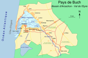
Map of the Bassin d'Arcachon |
||
The Bassin d'Arcachon ( Arcachon Basin or Bay of Arcachon ) is an approximately 155 square kilometer bay in southwest France .
Location and nature
The bay is located in the Nouvelle-Aquitaine region , in the Gironde department and in the Arcachon arrondissement a good 42 kilometers (as the crow flies) southwest of the city of Bordeaux . The basin has an approximately triangular shape and is almost separated from the Atlantic by the Cap Ferret peninsula . Are extended from the bay creeks crisscrossed mudflats .
There is still a remarkable flora and fauna here, some of which are rare species. Some parts of the bay are nature reserves. Within the Bassin d'Arcachon there is a bird protection island, the Île aux Oiseaux , which you are not allowed to enter. At the mouth of the bay in the Atlantic lies the sand bank Banc d'Arguin , a national nature reserve that serves numerous bird species as nesting and breeding grounds, as winter quarters or as a resting area.
Economy and tourism
Almost 350 fishermen (in decreasing numbers) still farm oysters in the bay, and their products are considered a delicacy in restaurants in the surrounding resorts, but also worldwide.
In addition to the tourist capital Arcachon , there are a number of other seaside resorts around the bay, such as Gujan-Mestras , Andernos-les-Bains or Arès with the usual tourist infrastructure such as marinas , hotels and holiday apartments, campsites and restaurants.
Other attractions in the immediate vicinity are Cap Ferret , with the famous lighthouse , and a little further south, the highest dune in Europe, the Dune du Pilat , with a height of around 110 meters.
climate
| month | Jan | Feb | Mar | Apr | May | Jun | Jul | Aug | Sep | Oct | Nov | Dec | |
|---|---|---|---|---|---|---|---|---|---|---|---|---|---|
| Highest temperature (° C) | 10.9 | 12.2 | 15.2 | 17.0 | 20.8 | 23.7 | 26.0 | 26.3 | 24.0 | 19.8 | 14.4 | 11.2 | |
| Lowest temperature (° C) | 2.5 | 2.5 | 4.5 | 6.6 | 10.3 | 13.3 | 15.1 | 15.0 | 12.1 | 9.7 | 5.6 | 3.2 | |
| Average temperature (° C) | 6.7 | 7.35 | 9.85 | 11.8 | 15.55 | 18.5 | 20.55 | 20.65 | 18.05 | 14.75 | 10 | 7.2 | |
| Precipitation (mm) | 95.5 | 74.9 | 66.4 | 79.6 | 62 | 56.4 | 46.9 | 59.1 | 77.8 | 99.9 | 120.8 | 107 | |
| Source: Météo-France , Normales 1981–2010. | |||||||||||||
Web links
- Official tourism website (French)


