Bay of Algeciras
| Bay of Algeciras | ||
|---|---|---|
| Waters | Mediterranean Sea | |
| Land mass | Iberian Peninsula | |
| Geographical location | 36 ° 8 ′ 8 ″ N , 5 ° 24 ′ 6 ″ W | |
|
|
||
| width | approx. 8 km | |
| depth | approx. 9 km | |
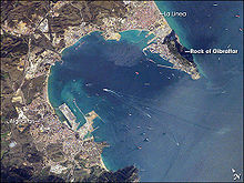
The Bay of Algeciras , and Gibraltar Bay , English Bay of Gibraltar called lies far to the south of Spain on the southern tip of the Iberian Peninsula. The western beginning of the Mediterranean coast is densely populated with the city of Algeciras in the west of the bay, the large Refineria de Gibraltar oil refinery in San Roque in the north, La Línea in the northeast, and the British overseas territory Gibraltar in the southeast of the bay.
On the Rock of Gibraltar , which belongs to Great Britain, lies next to the San Felipe Pier, the marina and the port of Gibraltar further south the Rosia Bay, the Camp Bay, the "small bay", the Bleak Beach and at the southern tip of the Europa Point . The bay merges with the Strait of Gibraltar to the south .

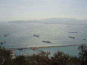
There are usually many oil tankers at anchor in the bay, as Gibraltar is one of the most important ports for refueling ships. There are also animals such as whales and dolphins (for example the bottlenose dolphin ), which is why many sightseeing tours by boat are offered in Algeciras and Gibraltar.
Just as the Rock of Gibraltar rises steeply out of the Mediterranean Sea, the coast falls down steeply to a depth of 400 m on the eastern edge of the bay in the area of the port facilities. However, some coral reefs as well as artificially created reefs such as the Artificial Reef Gibraltar near Rosia Bay and Camp Bay provide a livelihood for marine fauna. The Europa Reef, located southwest of the European peak, belongs to a series of sea terraces and has only been under water since the last Ice Age. It extends from the flat coastal area to a depth of over 300 m. Because of the strong currents in the Strait of Gibraltar and the exposed position at the entrance of the bay with an outstanding biodiversity , it was often the subject of marine research. The Seven Sisters Reef in the marine reserve "Rosia Marine Conservation Zone" further north in the Bay of Gibraltar is a hot spot for invertebrates .
Marine fauna and flora

Although the port facilities and shipping traffic have caused considerable damage, remains of seagrass meadows ( Zostera marina and Cymodocea nodosa ) have been preserved in the north of the bay . Hard corals ( Astroides calycularis ) and the long-spiked diadem sea urchin ( Centrostephanus longispinus ) occur according to the Department of the Environment of Gibraltar.
Even on the artificial reefs protected mussel species such as could in Europe Lithophaga lithophaga and Patella ferruginea settle.
The rich fishing grounds in the Bay of Algeciras / Gibraltar are controversial between Spain and Gibraltar: In 2013 there were again incidents in the fishing dispute in Gibraltar .
- environmental Protection
In addition to long-term valid "Beach Profiles" with site plans, environmental monitoring and environmental management for the bays and beaches, the environmental authority of Gibraltar also publishes short-term measured values for the quality of the bathing water. Strategies for the responsibility in Gibraltar have been developed for comprehensive protection of the natural environment in the bay through to the reduction of noise.
history
In 1607 the Battle of Gibraltar between the Spanish and Dutch navies took place in the Bay of Algeciras, among other places. In 1801 the Spanish and French fought two sea battles with the British in the bay. During the Second World War , the Italian Navy operated manned torpedoes against British ships stationed in Gibraltar in the bay. During the Falklands War , Argentina's army and secret services planned a commando operation from Algeciras against British ships stationed in Gibraltar in the bay.
Individual evidence
- ↑ a b c d Marine Strategy ( page no longer available , search in web archives ) Info: The link was automatically marked as defective. Please check the link according to the instructions and then remove this notice. (PDF, English; 1.8 MB) of the Gibraltar Administration (Department of the Environment), December 2012. Accessed August 23, 2013.
- ↑ Beach profiles, site plans (Bathing Water Profiles) and current quality of the bathing water ( memento of the original from August 17, 2013 in the Internet Archive ) Info: The archive link was automatically inserted and not yet checked. Please check the original and archive link according to the instructions and then remove this notice. , (English) Department of the Environment Gibraltar. Retrieved August 23, 2013.
- ↑ Article in the Guardian

