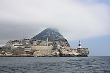
Europa Point
Europa Point is the English name for the flat southern end of the headland of Gibraltar , which protrudes into the Strait of Gibraltar ( Spanish: Punta Europa ; German: Europe point ). This cape in front of the Rock of Gibraltar is not the southern tip of the Iberian Peninsula - that is the Punta de Tarifa 25 km further south-west - but it is particularly eye-catching as a buildable area surrounded on three sides by water, from the land and sea side. For the same reason, for centuries it was of great nautical and strategic importance for the passage between the Mediterranean and the Atlantic and the transition from the North African to the South European mainland.
History and development
In the year 711 the Arab conquest of the Iberian Peninsula began here . The oldest building at Europa Point goes back to this time, a Moorish mosque , from the Reconquista to the British Conquest a Catholic Church , then used for military purposes, since 1967 as the shrine of Our Lady of Europe again a church. Its original bell tower also served as a lighthouse for centuries .
The underground double cistern Nun’s Well is also likely from the Moorish times .
From the Middle Ages to the Second World War , the top of Europe was secured by changing regimes with fortress structures . In British times until the 1960s, the entire area was reserved for military use. Barracks and army sports facilities are evidence of this to this day .
The Europa Point Lighthouse , which stands at the far end of the headland, was built in 1841. It is managed by Trinity House in London.
In 1995–1997 the Ibrahim-al-Ibrahim Mosque was built as a gift from King Fahd of Saudi Arabia .
An extensive redesign of the Europa-Point area has been carried out since 2011, with the aim of making it a top tourist attraction .
See also
- Europa Point FC (football club)
Web links
- Europa Point (Gibraltar Travel Guide, English)
- Ferrer-Gallardo, X. and Van Houtum, H. (2013), Europe without an Endpoint. Period. Tijdschr Econ Soc Geogr, 104: 243-249. doi : 10.1111 / tesg.12013
Individual evidence
- ↑ a b gibraltarinfo.gi ( Memento of the original from June 14, 2012 in the Internet Archive ) Info: The archive link was inserted automatically and has not yet been checked. Please check the original and archive link according to the instructions and then remove this notice.
- ↑ Well's Well
- ↑ Description of the Europa Point lighthouse on Trinity House , accessed on May 21, 2015
- ↑ Gibraltar Chronicle , October 21, 2011
Coordinates: 36 ° 6 ′ 34.6 " N , 5 ° 20 ′ 46.5" W.

