Gibraltar rock
| Gibraltar rock | ||
|---|---|---|
|
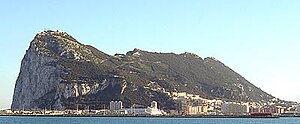
West flank of the Rock of Gibraltar, 2006 |
||
| height | 426 m | |
| location | Gibraltar | |
| Mountains | Betic Cordillera | |
| Coordinates | 36 ° 7 '33 " N , 5 ° 20' 35" W | |
|
|
||
| rock | limestone | |
| Normal way | Cable car, road, pedestrian stairs | |
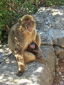
The Rock of Gibraltar ( English Rock of Gibraltar , Latin Calpe , Spanish Peñón de Gibraltar , Arabic جبل طارق, DMG Ǧabal aṭ-Ṭāriq ) is a monolithic limestone cliff that encompasses most of the Gibraltar peninsula on the south-western tip of Europe. It is considered one of the most famous rocks in the world and is a tourist attraction of the city-state of Gibraltar, which is one of the British overseas territories . Most of the rock is a nature reserve (also known as Upper Rock ) and is the habitat of over 250 Barbary macaques . These, as well as the defense tunnels dug in the rock, attract many tourists.
The Rock of Gibraltar is one of the pillars of Heracles , on which, according to the ancient worldview, the sky rests. The two pillars (the other was Monte Hacho or Jebel Musa on the south side of the Strait of Gibraltar ) marked the end of the known world.
geology
The Rock of Gibraltar is a monolithic headland . It is a severely eroded extension of an inverted fold . The sediments that make up the Rock of Gibraltar are stratigraphically upside down, i.e. the oldest rock layers on top. These layers are the Catalan Bay - slate (after the small fishing village on the sparsely populated eastern shore of Gibraltar) as the youngest layer, the Gibraltar-limestone and the oldest slate, Little Bay . The age of the Dockyard slate also found is unknown. The layers are clearly discarded and deformed.
The Catalan Bay slate consists primarily of slate, but also contains sandstone and limestone . It also contains ammonites from the Jurassic . The Gibraltar limestone consists of gray-white to pale-gray limestone and dolomite . It makes up about three quarters of the rock. Geologists have found various but poorly preserved and heavily weathered marine fossils in it. These fossils suggest an origin around the early Jurassic. The Little Bay and Dockyard formations make up only a small portion of the rock. The former is blue-gray slate without fossil inclusions, interrupted by thin layers of other types of rock. The Dockyard slate is largely undescribed because it is hidden under other layers.
The layers that make up the Rock of Gibraltar were formed in the early Jurassic, about 175–200 million years before our time, when the African Plate collided with the Eurasian Plate . The Mediterranean became a lake and dried up in the course of the Messinian salinity crisis , until the Strait of Gibraltar broke through about five to six million years ago and the present-day Mediterranean was created. The Rock of Gibraltar is part of the Betic Cordilleras , a mountain range that dominates the south of the Iberian Peninsula .
Today the Rock of Gibraltar forms a peninsula that extends into the street of the same name . The peninsula is connected to the Spanish mainland by a thin tombolo . At the north end, the rock rises vertically from sea level to 411.5 m to the so-called Rock Gun Battery , one of the many fortifications on Gibraltar. The highest point of the rock is 426 m above sea level, at O'Hara's Battery at the south end.
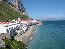
The eastern slope of the rock is steep and sandy. The sparse vegetation in this area is reminiscent of a desert. It is no longer possible to recognize that this steeply sloping sand dune was built with water drainage channels to collect drinking water until 2001. These catchment basins, which have been expanded in several stages since 1898, comprised 140,000 m 2 by 1961 . The water itself was stored in large caverns inside the rock. Since 2001 this rainwater catchment system has been demolished by the Gibraltar Ornithological and Natural History Society and the original vegetation has been restored. Sandy Bay and Catalan Bay are located on this sparsely populated east side . The Sir Herbert Miles Road leads on this side of the rock from north to south.

The west and south sides of the rock are very different. The rock is significantly flatter, at its foot lies the city of Gibraltar to the west and Europa Point to the south . The vegetation of the rock is very lush and dense here. Limestone, of which the Rock of Gibraltar is made, degrades over time through erosion. Therefore there are over a hundred caves here . St. Michael's Cave , about halfway up, is the most famous of them with nearly a million visitors annually. Another well-known cave is Gorham Cave at the southeast end. Archaeological finds show that Neanderthals must have lived in it.
Fortifications
The Rock of Gibraltar is interspersed with various defenses.
The Moorish Castle
The Moorish Castle (English: Moorish Castle ) is a relic from the time when Gibraltar was occupied by the Moors . It was built in 711 by Tariq ibn Ziyad , a Berber warlord . He was the first Muslim to land on Gibraltar, which is why the rock still bears his name in Arabic, Jabal at-Tariq , "Rock of Tariq".
From the Moorish castle, the Tower of Homage (for example: Tower of Honor) is mainly recognizable. It is a building made of solid bricks and hard cement. In the upper part of the tower are the living quarters of the former occupation and a Moorish bath .
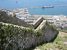
The Wall of Charles V
The wall of Charles V was built in 1552 roughly in the middle of the peninsula. The remaining part begins a little above the foot of the rock and leads to the ridge. In 2008 a footpath was opened on this wall, which makes it possible to practically climb the rock in the Direttissima .
The galleries
As already mentioned, the rock is criss-crossed by numerous tunnels and galleries. On the north flank are the Galleries , also called Great Siege Tunnels (for example: Tunnels of the Great Siege ). They were built towards the end of the Great Siege of Gibraltar 1779–1783 under George Augustus Eliott, 1st Baron Heathfield , who commanded the defenders. Although this was not initially planned, ventilation openings were made in the dug connecting tunnel to an upstream position on the north side. These were immediately equipped with cannons.
In 1797, after the siege (in which the defenders were able to withstand), more such tunnels were dug. They are now a tourist attraction and offer unusual views over the Bay of Gibraltar and southern Spain.
Second World War
When World War II broke out, all civilians were evacuated to Morocco , the United Kingdom , Jamaica and Madeira , leaving the military free to fortify Gibraltar against a possible German incursion. In 1942, over 30,000 British soldiers, sailors and pilots were stationed in Gibraltar. They expanded the tunnel system and made the rock a pillar of the defense of the shipping routes into the Mediterranean.
Various fortifications can still be discovered all over the rock, many of them largely destroyed due to lack of maintenance.
invincibility
Despite long sieges, Gibraltar has not fallen since the Middle Ages. An English proverb reads solid as the Rock of Gibraltar and describes a circumstance or a person who does not perish despite adverse circumstances. Gibraltar's motto is Nulli Expugnabilis Hosti ( Latin : can not be conquered by any enemy / cannot be conquered by any enemy ).
Upper Rock Nature Reserve

In 1993 a good 40% of Gibraltar's land area was declared a nature reserve. This is practically the whole of the rock. The IUCN lists the nature reserve in category Ia. The western flank of the rock is particularly important from an ecological point of view. The Barbary macaques that live on the rock are a specialty . They are the only non-human monkeys living in the wild in Europe (although today they are also fed). The origin of the monkeys has not been established for certain. It is believed that they were introduced during the Arab rule in southern Spain (711 to 1492). But it is also possible that they are a holdover from a population that populated southern Europe in the Pliocene .
Because of the comparatively mild climate on the rock, it is used as a resting place by many migratory birds during the migration period, in autumn when traveling south, in spring to the north.
Also among the plants are some species that only occur here in Europe, such as Iberis gibraltarica , a ribbon flower species .
Individual evidence
- ↑ Alternate Names or Name Variants for Gibraltar
- ↑ a b Welcome To The Rock of Gibraltar! by costarsure.com
- ^ Pillars of Hercules . The Gibraltar Museum. Archived from the original on July 20, 2007. Info: The archive link was inserted automatically and has not yet been checked. Please check the original and archive link according to the instructions and then remove this notice. Retrieved January 14, 2008.
- ↑ a b c d Rose, EPF, and MS Rosenbaum, 1991, A Field Guide to the Geology of Gibraltar , The Gibraltar Museum, Gibraltar. 192ff.
- ↑ El relieve kárstico de Gibraltar como el registro morfosedimentario durante Cuaternario (Mediterráneo occidental) . In: Boletín de la Sociedad Española de Espeleología y Ciencias del Karst . 2002, p. 7.
- ↑ Discover Gibraltar : East Side / Sandy Bay (English)
- ↑ St. Michael's Cave ( Memento of the original from November 22, 2010 in the Internet Archive ) Info: The archive link was automatically inserted and not yet checked. Please check the original and archive link according to the instructions and then remove this notice.
- ↑ DNA solves mystery of Gibraltar's macaques
Web links
- Gibraltar . In: Gibraltar: the Travel Key to the Mediterranean . 1931, pp. 5-12.


