Bucketts Way
| Bucketts Way | ||||||||||||||||||||||||||||||||||||||||||||||||||||||||||||||||
|---|---|---|---|---|---|---|---|---|---|---|---|---|---|---|---|---|---|---|---|---|---|---|---|---|---|---|---|---|---|---|---|---|---|---|---|---|---|---|---|---|---|---|---|---|---|---|---|---|---|---|---|---|---|---|---|---|---|---|---|---|---|---|---|---|
| Basic data | ||||||||||||||||||||||||||||||||||||||||||||||||||||||||||||||||
| Operator: | Roads and Maritime Services | |||||||||||||||||||||||||||||||||||||||||||||||||||||||||||||||
| Start of the street: |
northeast of Raymond Terrace ( NSW ) ( 32 ° 39 ′ S , 151 ° 52 ′ E ) |
|||||||||||||||||||||||||||||||||||||||||||||||||||||||||||||||
| End of street: |
Taree ( NSW ) ( 31 ° 56 ′ S , 152 ° 29 ′ E ) |
|||||||||||||||||||||||||||||||||||||||||||||||||||||||||||||||
| Overall length: | 149 km | |||||||||||||||||||||||||||||||||||||||||||||||||||||||||||||||
|
States : |
||||||||||||||||||||||||||||||||||||||||||||||||||||||||||||||||
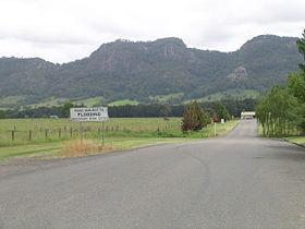
| Bucketts Range from Bucketts Way | ||||||||||||||||||||||||||||||||||||||||||||||||||||||||||||||||
|
Course of the road
|
||||||||||||||||||||||||||||||||||||||||||||||||||||||||||||||||
The Bucketts Way is a connecting road in the east of the Australian state of New South Wales . He branches off the Pacific Highway north of Raymond Terrace on the Hunter River and meets him again at Taree . The Pacific Highway ran along this route from 1928 to 1952.
Origin of name
The road was named after a higher mountain range near Gloucester , the Bucketts .
course
14 km northeast of Raymond Terrace branches off the Bucketts Way north from the Pacific Highway (R1). It crosses the Karuah River about 8.5 km south of Stroud and then follows the course of the river 25 km to the north-northwest. Then the road turns to the north-northeast and a little later to the north and after 20 miles it reaches Gloucester . She crosses the Mammy Johnsons River and the Avon River . The North Coast Railway runs along the road from Stroud Road to Gloucester .
From Gloucester, the Thunderbolts Way continues north into the New England table country . The Bucketts Way turns sharply to the east and later to the east-southeast until it reaches the town of Krambach . There it turns again to the north and then again to the east at Burrell Creek , along the south bank of the Nowendoc River . At Taree it then reaches the Pacific Highway (R1) again.
meaning
The Bucketts Way provides access to Barrington Tops National Park and serves tourists as an alternative route to the Pacific Highway that is worth seeing.
Planned renaming
Some Gloucester Shire MPs suggested adding the stretch south of Gloucester to Thunderbolts Way, as some road maps already show. This would result in a continuously named road from the Pacific Highway at Raymond Terrace to the New England Highway at Uralla . However, there are major objections to this proposal from the neighboring communities.
source
Steve Parish: Australian Touring Atlas . Steve Parish Publishing. Archerfield QLD 2007. ISBN 978-1-74193-232-4 . P. 27
Individual evidence
- ^ Bucketts Way - Formerly part of the Pacific Highway from 1928 until 1952 . Ozroads. Retrieved May 15, 2008
-
^ NSW Imagery . In: Department of Lands - Spatial Information eXchange . New South Wales Department of Lands. Archived from the original on May 25, 2008. Info: The archive link was inserted automatically and has not yet been checked. Please check the original and archive link according to the instructions and then remove this notice. Retrieved May 23, 2009. Maps: 9232 Newcastle, 9233 Dungog, 9234 Upper Manning, 9334 Wingham
- ^ Bucketts Way - Road Re-Naming . Great Lakes Council . Archived from the original on September 24, 2009. Info: The archive link was automatically inserted and has not yet been checked. Please check the original and archive link according to the instructions and then remove this notice. Retrieved October 3, 2009.
