
Lenzenberg Castle
| Lenzenberg Castle | ||
|---|---|---|
 Lenzenberg Castle - View of the castle rock from the north |
||
| Alternative name (s): | Linzenberg, Langenfels | |
| Creation time : | 1100 to 1200 | |
| Castle type : | Höhenburg, spur location | |
| Conservation status: | Burgstall | |
| Standing position : | Nobles | |
| Construction: | Small cuboid, quarry stone masonry | |
| Place: | Sigmaringen - Gutenstein | |
| Geographical location | 48 ° 4 '58.8 " N , 9 ° 3' 57.3" E | |
| Height: | 790 m above sea level NN | |
|
||

The castle Lenzenberg , even long rock or Linz mountain called, is a Outbound Spur castle on the 790 m above sea level. NN high "Lenzenfelsen" near Gutenstein , a district of Sigmaringen in the district of Sigmaringen in Baden-Württemberg .
history
The castle was possibly built in the 12th century under the Counts of Montfort , who had come to the Sigmaringen rule through succession. An Algozo von Linzenberg Friedberg was mentioned as one of their feudal men around 1216, and an Albero von Linzenberg was mentioned in 1228. The castle was probably destroyed by the great earthquake in Friuli in 1348 . Around 1362 the Lenzenberg property and the nearby Falkenstein Castle were in the hands of the Lords of Magenbuch. On October 3, 1390, Albrecht von Magenbuch sold “Linczenberg das burgstall” with accessories and the two castles Oberstein and Unterfalkenstein to Heinrich von Bubenhofen . In the 16th century it was mentioned in the Zimmerische Chronik as a castle stable .
description
The former castle complex is divided into a horseshoe-shaped, approximately 700 square meter outer bailey (Fig. 2), with an 8 to 12 meter wide neck ditch facing southwest to the Alb plateau (Fig. 3) and a slightly smaller core castle on a narrow rock spur , slightly offset to the northwest (Picture 4). Sparse remains of rubble from a once polygonal perimeter wall and an approximately 3 meter wide and 10 meter long, leveled outcrop on its eastern rock face are evidence of the outer bailey, which suggests a building in an exposed location.
At its northern end, a second ditch cuts through the castle complex. A shield wall around 2.8 meters thick and 19 meters long rose behind this trench section to protect the core castle (Fig. 5). Small remains of this wall can be found at its northwestern end. On the south-eastern flank, at the highest point of the rock, there was a trapezoidal structure, probably a residential tower (Fig. 6), with a length of 12.5 meters and a width between 7.10 meters (on the shield wall) and 4.60 meters. Remnants of the wall have been preserved from him: north-west side - core masonry and small remains of facing from small blocks; on the south-east side - a 65 × 40 × 42 centimeter limestone block of the south corner; a wall remnant made of small cuboids in regular stratification on the eastern corner (Fig. 7) and in the middle of the building, three isolated cuboids. Holes and isolated stone blocks in the ground indicate further buildings. The north-eastern spur tip of the core castle marks a leveled rock step that was probably once built up (Figs. 8 and 9) - today a popular viewing platform with a clear view of the Falkenstein double ruins , the Schaufelsen ( 772 m above sea level ) with the Schauenburg ruins , the rock formation with it the Neidinger Heidenschloss and the northeastern Burgstall Auchtbühl .
photos

Photo 2: The horseshoe-shaped plateau of the outer bailey

Fig. 3: Neck ditch directed towards the Alb plateau, partly designed as a pointed, partly as a sole ditch
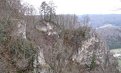
Photo 4: Core castle from the southeast
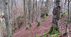
Image 5: View from today's access path to the castle site on the core castle. The path leads through the moat, past the outer bailey on the left and through the former shield wall to the spur plateau of the inner bailey
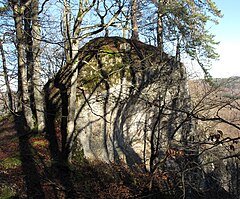
Image 6: Main rock with remains of the residential tower
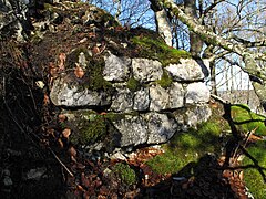
Photo 7: Remnants of the wall at the eastern corner of the residential tower
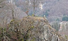
Image 8: Tower-like north-eastern spur tip of the inner castle
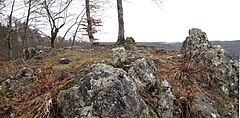
Image 9: Exposed north-eastern spur seats - probable location of another structure and less vulnerable on the valley side, at the same time a representative lookout that can be seen from afar.


literature
- Günter Schmitt : Castle Guide Swabian Alb. Volume 3: Danube Valley: hiking and discovering between Sigmaringen and Tuttlingen . Biberacher Verlagsdruckerei, Biberach an der Riß 1990, ISBN 3-924489-50-5 , pp. 131-136.
- Christoph Bizer, Rolf Götz: Forgotten castles of the Swabian Alb . DRW-Verlag, Stuttgart 1989, ISBN 3-87181-244-7 , pp. 103-105.
- Hans-Wilhelm Heine : Studies on weir systems between the young Danube and western Lake Constance. Published by the Baden-Württemberg State Monuments Office, Stuttgart 1978, DNB 820727776 , p. 95.
Web links
- Reconstruction drawing by Wolfgang Braun
Individual evidence
- ↑ cf. The Cistercian convent in Wald - manorial rule, jurisdiction and administration . Works on regional studies Hohenzollern - Issue 9, p. 377.
- ↑ Hans-Wilhelm Heine: Studies on weir systems between the young Danube and western Lake Constance. P. 95.
- ↑ Günter Schmitt: Burgenführer Schwäbische Alb, Volume 3 - Danube Valley: Hiking and discovering between Sigmaringen and Tuttlingen. P. 134.