
Liebenstein castle ruins (Arnreit)
| Liebenstein castle ruins | ||
|---|---|---|
 Liebenstein castle ruins after an engraving by Georg Matthäus Vischer from 1674 |
||
| Alternative name (s): | Thumb, Daim, Alt-Liebenstein | |
| Creation time : | 1161 (first documented mention) | |
| Castle type : | Hilltop castle | |
| Conservation status: | Burgstall | |
| Place: | Arnreit municipality | |
| Geographical location | 48 ° 31 '16.6 " N , 13 ° 58' 51.7" E | |
| Height: | 519 m above sea level A. | |
|
||

The Castle Liebenstein , also Fortress Thumb, Daim or Alt-Liebenstein called, is a Outbound hilltop castle on 519 m above sea level. A. in the municipality of Arnreit in the Rohrbach district of Upper Austria (Daim 7).
history
Liebenstein was built by the Passau bishops around 1161 and given to feudal men . After their extinction, the castle fell back to the bishopric to be re-assigned. Pabo de Liebenstain is mentioned here in 1170. In 1241 Wicherus et Dietmarus de Liebenstain are mentioned and in 1258 Agnes von Liebenstein , a niece of Passau bishop Otto and wife of Albero von Puchberg. In 1279 a Hadmar von Liebenstain is mentioned. In 1382 there is talk of the "Vest zu Liebenstain".
In 1433, Berthold von Losenstein received this fortress from Bishop Leonhard von Passau as a fief and as an inheritance. The Losensteiners had the castle administered by carers : as such, Dankwart the Hautzenberger is mentioned in 1410 and 1413, and Urban the Rasp in 1435, 1441 and 1445. In 1457 Ulrich von Starhemberg bought the Liebenstein fortress from Hartneyd von Losenstein. As a result, Liebenstein was beaten to Pürnstein and administered from there.
Liebenstein Castle then and now
As can be seen from the engraving by Georg Matthäus Vischer from 1674, Liebenstein was already in ruins in the 17th century . At that time, still a high raised upper room of a palace that with a crenellated was surrounded wall.
The castle hill is still clearly visible today, the remains of the wall are no longer there. The castle hill drops off steeply to the north and west. The remarkable Schmidthäusl property (Daim No. 7), which was built from the remains of the castle in the 17th century, is located on the eastern slope.
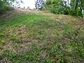
Castle Hill Daim

Schmidthäusl - Daim 7
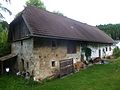
Schmidthäusl - Daim 7


literature
- Norbert Grabherr : Castles and palaces in Upper Austria. A guide for castle hikers and friends of home . 3. Edition. Oberösterreichischer Landesverlag, Linz 1976, ISBN 3-85214-157-5 .
- Christian K. Steingruber : A critical consideration of the historical-topographical manual of the fortifications and mansions of Upper Austria . Upper Austrian Provincial Archives , Linz 2013.
Individual evidence
- ^ Entry on Burg Alt-Liebenstein in the private database "Alle Burgen". Retrieved September 17, 2015.
- ↑ Julius Strnadt : Attempting a history of the Passau rule in the upper Mühlviertel, namely the district court of Velden until the end of the Middle Ages. In: Yearbook of the Upper Austrian Museum Association. Year 20, Linz 1860, pp. 73–288 ( PDF (12.6 MB) on ZOBODAT ).