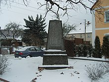
Burkersdorf (outskirts)
Burkersdorf is a district of the southern Brandenburg town of Ortrand in the Oberspreewald-Lausitz district in the Ortrand district .
geography
Burkersdorf is located in Upper Lusatia, north of the Pulsnitz , which forms the border between Upper Lusatia and Schraden . Ortrand on the southern opposite bank of the Pulsnitz is already in the Schraden. To the west of Burkersdorf are the places Großkmehlen and Frauwalde as well as Lindenau . In the north the place borders on Frauendorf and in the east the Kroppen with Heinersdorf .
history
The street village of Burkersdorf was first mentioned in a document in 1366. The place name developed from Burckersdorff in 1498 to Burkerssdorff in 1543 and Burckerßdorff in 1604 to Burckersdorf in 1791. The manor Lindenau has evidently exercised the manor from 1543 onwards. From the 16th century, Burkersdorf was parish after Kroppen. The Burkersdorf children attended school here until the school was built in 1810. In 1904 a cemetery was laid out on the Burkersdorfer Flur. The volunteer fire brigade Burkersdorf was founded in 1937. Until 1952 the place belonged to the district of Hoyerswerda and then came to the newly established district of Senftenberg . On January 1, 1960, Burkersdorf is incorporated into the outskirts.
Population development
| Population development in Burkersdorf from 1777 to 1950 | |||||||||||
|---|---|---|---|---|---|---|---|---|---|---|---|
| year | Residents | year | Residents | year | Residents | year | Residents | year | Residents | year | Residents |
| 1777 | 17 possessed men, 17 gardeners, 4 cottagers, 2 devastation | 1825 | 235 | 1875 | 367 | 1890 | 346 | 1905 | 394 | 1910 | 416 |
| 1925 | 460 | 1933 | 587 | 1939 | 664 | 1946 | 750 | 1950 | 754 | ||
Attractions
In Burkersdorf there is a memorial for those who died in the First World War.
Infrastructure
The federal motorway 13 runs west of Burkersdorf .
Web links
- Timeline of the history of the city of Ortrand on the homepage of the city of Ortrand , accessed on June 27, 2009.
- Burkersdorf in the Digital Historical Directory of Saxony , accessed on June 27, 2009.
literature
- Dietrich Hanspach among others: The Schraden. A regional study in the Elsterwerda, Lauchhammer, Hirschfeld and Ortrand area . Ed .: Luise Grundmann on behalf of the Institute for Regional Geography Leipzig and the Saxon Academy of Sciences in Leipzig. Böhlau Verlag, Cologne, Weimar, Vienna 2005, ISBN 3-412-10900-2 , pp. 243-244 .
Individual evidence
- ↑ Brandenburg Statistics (PDF)
- ↑ Online project Memorials to Fallen. , Lawrenceville, USA, accessed February 13, 2010 .
Coordinates: 51 ° 22 ′ 50.4 " N , 13 ° 45 ′ 31.8" E

