Burkhardsreuth
|
Burkhardsreuth
Trabitz municipality
Coordinates: 49 ° 47 ′ 46 " N , 11 ° 52 ′ 38" E
|
||
|---|---|---|
| Height : | 463 m above sea level NN | |
| Residents : | 49 (1987) | |
| Postal code : | 92724 | |
| Area code : | 09644 | |
|
Location of Burkhardsreuth in Bavaria |
||
|
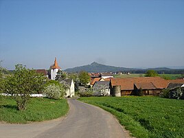
Burkhardsreuth with the parish church of St. Jakob; in the background the 681 meter high Rauhe Kulm
|
||
Burkhardsreuth is a part of the municipality of Trabitz in the Upper Palatinate district of Neustadt an der Waldnaab ( Bavaria ).
location
The parish village lies in the open, just under 1.5 km southwest of the core town of Trabitz.
Architectural monuments
The following are listed as architectural monuments in Burkhardsreuth (see list of architectural monuments in Trabitz # Burkhardsreuth ):
- the Gothic tower (with pointed helmet) of the former choir tower church (the church itself is a new building from 1958)
- the essentially medieval cemetery wall with arched portals, which probably date from the 19th century
- three neo-Romanesque grave monuments from the last quarter of the 19th century on the cemetery wall


