Camdeboo National Park
|
Camdeboo National Park
|
|
| location | Eastern Cape, South Africa |
| surface | 19,405 ha |
| WDPA ID | 4035 |
| Geographical location | 32 ° 15 ′ S , 24 ° 30 ′ E |
| Setup date | 1979 (Karoo Nature Reserve) October 30, 2005 (Camdeboo National Park) |
| administration | South African National Parks |
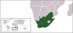
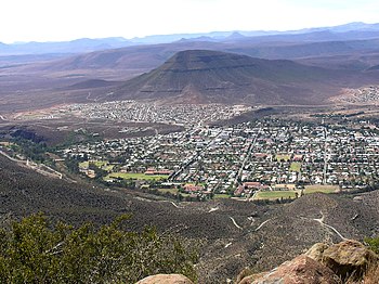
The Camdeboo National Park ( English Camdeboo National Park ) is a national park in the vicinity of the South African city of Graaff-Reinet , in the Eastern Cape Province . It consists of a western and an eastern part. The two areas of the Camdeboo National Park extend around the historical core of the city of Graaff-Reinet. The Nqweba Dam adjacent to the urban area is another part of its area.
description
The two parts of the national park together have a total area of 14,500 hectares. Considering its relationship to the environment, the national park is in an unusual position for South Africa. It covers almost the entire area of a medium-sized town with 44,317 inhabitants (2001). This gives rise to mutual socio-economic relationships. The usual industrial and commercial outskirts are not possible in Graaf-Reinet in the usual form.
The most important areas of the national park are at an altitude of between 740 and 1,480 meters at the foot of the Sneeuberg slopes. He is right on the Great Escarpment (Great Escarpment). The national park area merges north and west from the foothills of the adjacent elevations into their upstream plains. There are several entry points for visitors. The preferred tourist area is to the west of the city. The eastern part is less intensively developed for tourist use. There are roads in the national park area for rental and ranger vehicles as well as hiking trails to the attractive points.
The soil and vegetation conditions in the nearby mountains have been the goal of ecological and geological observations for a long time. Serious soil erosion phenomena occur here. The problems of soil erosion in the nearby mountains can be observed in the national park. In the basin of the Nqweba Dam, large amounts of fluvial sediments have been carried over the years by the tributaries ( Sundays River and two small watercourses) . Its water absorption capacity is only around 60 percent.
The peculiarity of this pedological and hydrological situation is also expressed in the form that visitors are asked to remain in their vehicles if possible and to leave the national park area in the event of heavy rain, as otherwise there is a risk of their temporary isolation.
Research deals with the development of vegetation in the silting zones of the Nqweba Dam. In particular, one observes the invasive occurrence of tamarisk plants in their wet zones.
The Valley of Desolation is a bizarre rock valley, which is a special sight as a natural monument due to its columnar secretions of Karoo dolerites .
Creation of the national park
The nearby Valley of Desolation was granted National Monument status in 1935. In September 1974, Anton Rupert of the South African Nature Foundation proposed the establishment of a Karoo Nature Reserve with the rock valley as the core area. He started this idea with a campaign among schoolchildren, who ideally pushed the project forward by buying symbolic share certificates. Then on August 24, 1976, the 2,698 hectare was Nature Reserve Karoo Nature Reserve opened by means of an official act. The area intended for development was expanded in 1993 by purchasing more land on a former golf course . On October 29, 2005, the site was granted national park status. A merger with the Mountain Zebra National Park is planned with a gradual expansion .
Settlement history
Members of the Inqua tribe lived in the region of today's national park since the middle of the 17th century. They used the land as shepherds. Members of the Khoikhoi immigrated from the mountains .
The first European immigrants settled in the Camdeboo plains around 1770. With them merino sheep , angora goats and strange plants came into the area.
Transport infrastructure
The traffic development is cheap, the national park can be reached via the national roads N9 and N10 as well as the regional road R63.
Web links
- South African National Parks: Camdeboo National Park . National park administration website at www.sanparks.org (English)
- South African National Parks: CNP Park Management Plan , National Park Organization and Development Plan . on www.sanparks.org (English)


