
Eastern Cape
| Oos-Kaap Eastern Cape Mpuma Colonies Eastern Cape
|
||
|---|---|---|
  |
||
| Symbols | ||
|
||
| Basic data | ||
| Country | South Africa | |
| Capital | Bhisho | |
| surface | 168,966 km² | |
| Residents | 6,562,053 (2011) | |
| density | 39 inhabitants per km² | |
| ISO 3166-2 | ZA-EC | |
| Website | www.ecprov.gov.za (English) | |
| politics | ||
| prime minister | Oscar Mabuyane | |
| Political party | ANC | |

Coordinates: 32 ° 0 ′ S , 27 ° 0 ′ E
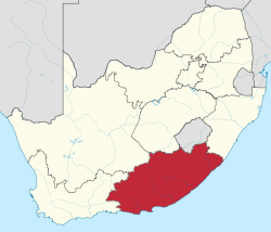
Eastern Cape ( Afrikaans Oos-Kaap , English Eastern Cape , IsiXhosa IPhondo yaMpuma-Koloni ) is a South African province in the southeast of the republic. It covers an area of 169,580 km² and has around 6.6 million inhabitants, 85 percent of whom belong to the Xhosa population . The Eastern Cape Province was created in 1994 through the union of the southeast of the Cape Province with the former homelands Ciskei and Transkei . The capital is Bhisho .
With an index value of 0.617 in 2015, the Eastern Cape has the lowest human development index of any province in the country.
geography
The largest city in the Eastern Cape and next to East London the most important industrial location is Port Elizabeth . Because there are no significant mineral resources in the Eastern Cape, the province is a region of the country with little industrialization and low-income, rural settlements. Their main economic potential lies in agriculture and forestry.
The landscape is largely untouched and offers an extraordinary variety of morphological phenomena and ecosystems, from the wasteland of the Great Karoo to the Knysna Forest , mountain areas up to over 2000 meters above sea level and to the fertile farmland between the Little Karoo and Langkloof plains enough. The vegetation is very varied: there are remnants of evergreen extra-tropical forests as well as fynbos vegetation, grasslands and thorn bush savannah . At Hogsback and in Tsitsikamma National Park there are evergreen forests with native tree species.
The high altitudes of the province are highly differentiated and geologically and naturally diverse. The most important mountain landscapes include sections of the Great Peripheral Steps , such as Sneeuberg , Bamboesberg , Stormberge and the western foothills of the Drakensberg Mountains , as well as the Bankberg , Winterberge and Amathole Mountains as well as the elevations within the folding zone of the Cape Supergroup, the Grootwinterhoekberge , Baviaanskloofberge and the Tsitsikammaberge . The mountain scenery of the Wild Coast, including its inland, is particularly rugged .
Districts with the parishes
The territorial structure of the Eastern Cape Province consists of 6 districts with 31 local parishes and two metropolitan parishes (as of July 2020):
.svg)
| District / Metropolitan Municipality | Local parishes | |
|---|---|---|
| 1. | Sarah Baartman | Blue Crane Route , Dr Beyers Naudé , Kouga , Kou-Kamma , Makana , Ndlambe and Sundays River Valley |
| 2. | Chris Hani | Emalahleni , Engcobo , Enoch Mgijima , Intsika Yethu , Inxuba Yethemba and Sakhisizwe |
| 3. | Joe Gqabi | Elundini , Senqu and Walter Sisulu |
| 4th | Alfred Nzo | Matatiele , Mbizana , Ntabankulu and Umzimvubu |
| 5. | OR Tambo | Ingquza Hill , King Sabata Dalindyebo , Nyandeni , Mhlontlo and Port St. Johns |
| 6th | Amathole | Amahlathi , Great Kei , Mbhashe , Mnquma , Ngqushwa and Raymond Mhlaba |
| 7th | Nelson Mandela Bay Metropolitan Municipality | Metropolitan municipality |
| 8th. | Buffalo City Metropolitan Municipality | Metropolitan municipality |
traffic
Air traffic
There are inland airports in East London, Port Elizabeth and Mthatha . They are mainly served from airports in Cape Town and Johannesburg .
Shipping
The larger port cities on the coast have cargo ports. The focus is on Port Elizabeth, the Port of Ngqura and East London. There is no inland waterway transport with freight. The low water flow, the sediment load and some water management structures do not allow this.
Road network
In the Eastern Cape Province today, the road network forms the main traffic connection between the villages. The railway network that emerged early on has lost its importance in comparison. The national road N2 crosses the province from southwest to northeast. Coming from Cape Town, it connects the cities of Port Elizabeth, Makhanda, King William's Town, Mdantsane , East London, on to Mthatha, where it bypasses the inaccessible area of the Wild Coast . From there it continues to Kokstad in the neighboring province of KwaZulu-Natal and continues towards Durban. Between King William's Town and East London and west of Port Elizabeth to the town of Thornhill , it has been developed as a four-lane motorway .
The N6 national road begins in East London and connects to the inland areas northwest of this city. It touches the cities of Macleantown and Stutterheim , then overcomes the eastern foothills of the Amathole Mountains , as well as Cathcart , Queenstown and the traffic junction Aliwal North . In the latter city, it crosses the Orange River , thus the provincial border and continues to Bloemfontein in the province of Free State .
From the west, from the region around Oudtshoorn, the national road N9 extends over the western part of the province. It reaches the area at Ghwarriepoort ( mountain pass ), leads through relatively sparsely populated landscapes to Graaff-Reinet . Then it touches the eastern foothills of the Sneeuberg massif with the village of Bethesdaweg and then reaches Middelburg . There it briefly follows the course of the N10, leaving the provincial area south of the village of Carlton in a northerly direction to Colesberg , where it ends in the N1 .
The N10 national road leads from the Northern Cape Province via Britstown to the western part of the Eastern Cape Province and reaches its area north of Middelburg. It joins briefly with the N9, which it leaves after this town and leads via Cradock to the coastal area. It is picked up by the N2 near the town of Ncanaha just before Port Elizabeth.
The traffic route network between the national roads is formed by regional roads through sometimes impassable, dry and mountainous areas. There are numerous unpaved roads in the remote regions.
Since 2003, a provincial law (Eastern Cape Roads Act, No. 3/2003) has regulated the tasks of the provincial administration for the road network for which it is responsible. This repealed the 1976 Roads Ordinance regulations. The province receives financial grants from the national PRMG (Provincial Road Maintenance Grant) fund for road maintenance.
Population and languages

According to the results of the 2011 census, 86.3% of the population belonged to the black population, 4.7% to the whites, 8.3% to the coloreds and 0.4% to the Indians and Asians.
78.8% of the population gave isiXhosa their mother tongue, Afrikaans 10.6%, English 5.6%, Sesotho 2.5%.
The following overview shows the population by area since the 1996 census.
| year | population |
|---|---|
| 1996 (census) | 6,147,244 |
| 2001 (census) | 6,278,651 |
| 2011 (census) | 6,562,053 |
| 2018 (estimate) | 6,522,700 |
politics

In the elections in 2019 to the provincial legislature , the ANC remained the strongest party in the Eastern Cape. The mandates are distributed as follows.
| Political party | Seats | +/- |
|---|---|---|
| African National Congress (ANC) | 44 | −1 |
| Democratic Alliance (DA) | 10 | ± 0 |
| United Democratic Movement (UDM) | 2 | -2 |
| Economic Freedom Fighters (EFF) | 5 | +3 |
| African Transformation Movement (ATM) | 1 | +1 |
| Vryheidsfront Plus (VF +) | 1 | +1 |
| total | 63 |
Cities (selection)
- Alice
- Aliwal North
- East London
- King William's Town
- Makhanda
- Mthatha
- Port Alfred
- Port Elizabeth
- Queenstown
- Somerset East
- Uitenhage
Higher education institutions
There are three higher education institutions in the province. Two of them have strong international ties and have made a significant contribution to the scientific development of South Africa over a period of more than a hundred years. These are:
Of historic importance for agricultural education across the country is the Fort Cox College of Agriculture and Forestry at Keiskammahoek .
National parks and nature reserves
Personalities
The old university town of Grahamstown - Makhanda since 2018 - with the bishopric, the former British administrative center King William's Town as well as the port cities of East London and Port Elizabeth as well as other places were and are the workplaces of many historically significant personalities for South Africa. They include the German-born natural scientist Selmar Schönland , his son Basil Schonland , the Prussian officer Richard von Stutterheim , the discoverer Marjorie Courtenay-Latimer , the missionaries James Stewart and Jane Elizabeth Waterston as well as the artist Churchill Madikida and the musician Alex van Heerden .
Many well-known personalities of the anti- apartheid movement , such as Nelson Mandela , Govan Mbeki and Thabo Mbeki , Walter Sisulu , as well as Chris Hani , Steve Biko and Albertina Sisulu come from this province, as the former homelands Ciskei and Transkei were traditional settlement areas in their area Xhosa . Other civil rights activists, such as Allan Hendrickse , were also born in the Eastern Cape.
gallery

Road R63 at Middledrift in the former homeland Ciskei , looking north

Valley of the Tyhume River at the foot of the Amathole Mountains

Cape Aloe ( Aloe ferox )


Web links
- Provincial administration website . on www.ecprov.gov.za (English)
- Eastern Cape Parks & Tourism Agency . at www.visiteasterncape.co.za
- Department of Water and Sanitation: Development of an internal strategic perspective for the Amatole-Kei Area of the Mzimvubu to Keiskamma Water Management Area (WMA No. 12) . at www.dwaf.gov.za (English; PDF file; 6.3 MB), Strategic Perspectives on Water Production in the Province
- Department of Water and Sanitation: Amatole-Kei internal strategic perspective, Appendices . on www.dwaf.gov.za (English; PDF file; 307 kB), water supply systems in the province
Individual evidence
- ↑ Statistics South Africa : Census 2011, Census in brief . online at www.statssa.gov.za (English, PDF file; 2.8 MB), PDF document p. 23, doc. p. 18.
- ^ Sub-national HDI - Area Database - Global Data Lab. Accessed August 5, 2018 .
- ^ Local Government Handbook. South Africa: Eastern Cape . at www.municipalities.co.za (English).
- ^ Local Government Handbook. South Africa: Eastern Cape Municipalities . at www.municipalities.co.za (English).
- ↑ LegalB's Resources for Africa: Eastern Cape Roads Act (Act No. 3/2003) . at www.legalb.co.za (English).
- ^ Parliamentary Monitoring Group: Provincial Roads Maintenance Grant: National Treasury, North West Province, and Western Cape: hearings . at www.pmg.org.za (English)
- ↑ Statistics South Africa (Ed.): Census 2011: Census in brief . Pretoria 2012, ISBN 978-0-621-41388-5 ( gov.za [PDF]).
- ↑ South Africa: Provinces and Major Settlements - Population Statistics, Maps, Charts, Weather, and Web Information. Retrieved January 7, 2019 .
- ^ Fort Cox Agriculture and Forestry Training Institute: Fort Cox History . at www.fortcox.ac.za (English).