Great kei
| Great Kei Great Kei Local Municipality |
||
|---|---|---|
 |
||
| Symbols | ||
|
||
|
Motto "Empowerment through Development" , " Self-determination through development" |
||
| Basic data | ||
| Country | South Africa | |
| province | Eastern Cape | |
| District | Amathole | |
| Seat | Komga | |
| surface | 1736 km² | |
| Residents | 38,991 (October 2011) | |
| density | 22 inhabitants per km² | |
| key | EC123 | |
| ISO 3166-2 | ZA-EC | |
| Website | www.greatkeilm.gov.za (English) | |
| politics | ||
| mayor | Loyiso Tsetsha | |
Coordinates: 32 ° 35 ' S , 27 ° 53' E
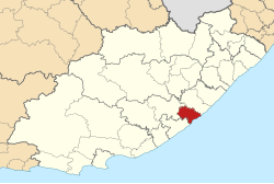
The community ( local Municipality ) Great Kei is part of the district Amathole , Province of Eastern Cape in South Africa . 38,991 inhabitants live in an area of 1,736 km² (as of 2011). The seat of the municipal administration is Komga .
The community name is based on the Great Kei River . The Khoi word Kei means "sand". The "great sandy river" is the largest river in the municipality.
Cities / places
population
In 2011 the community had 38,991 inhabitants. Of these, 91.3% were black, 7.2% white and 1.3% colored .
The first language was 87.3% IsiXhosa , 6.9% English and 2.7% Afrikaans.
Web links
- Side of the community. on www.greatkeilm.gov.za (English)
- The Local Government Handbook: Great Kei Local Municipality (EC123) . on www.localgovernment.co.za (English)
Individual evidence
- ^ Municipal boundaries South Africa
- ↑ Meaning of the name municipalities ( Memento from August 29, 2019 in the Internet Archive ) (English)
- ↑ http://www.statssa.gov.za/?page_id=993&id=great-kei-municipality
