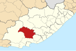
Blue Crane Route
| Blue Crane Route Blue Crane Route Local Municipality |
||
|---|---|---|
 |
||
| Symbols | ||
|
||
| Basic data | ||
| Country | South Africa | |
| province | Eastern Cape | |
| District | Sarah Baartman | |
| Seat | Somerset East | |
| surface | 9836 km² | |
| Residents | 36.002 (October 2011) | |
| density | 3.7 inhabitants per km² | |
| key | EC102 | |
| ISO 3166-2 | ZA-EC | |
| Website | www.bcrm.gov.za (English) | |
| politics | ||
| mayor | Bonisile Manxoweni | |
Coordinates: 32 ° 43 ′ S , 25 ° 36 ′ E
Blue Crane Route (full English Blue Crane Route Local Municipality ) is a local municipality in the Sarah Baartman district of the Eastern Cape Province of South Africa . The local government is based in Somerset East . Mayor is Bonisile Amos Manxoweni.
The community is named after a South African national symbol, the blue crane ( paradise crane ).
Cities / places
population
In 2011 the community had 36,002 inhabitants. 59% of these were black, 33% colored and 6.8% white. The mother tongues were 50.1% IsiXhosa , 42.2% Afrikaans and 3.3% English.
Web links
- The community site (English)
Individual evidence
- ^ Local Government Handbook. South Africa: Blue Crane Route Local Municipality (EC102) . at www.municipalities.co.za (English).
- ↑ Blue Crane Route: Our Councilors . at www.bcrm.gov.za (English).
- ^ Department of Arts and Culture: Place Names . at www.salanguages.com (English).
- ↑ 2011 Census: Blue Crane Route . accessed on August 26, 2020.
- ^ Statistics South Africa : Blue Crane Route . at www.statssa.gov.za (English).
