Tyhume River
| Tyhume River | ||
|
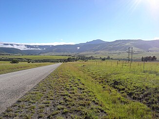
The Tyhume Valley with a view of the Hogsback Pass |
||
| Data | ||
| location | South Africa | |
| River system | Keiskamma River | |
| Drain over | Keiskamma River → Indian Ocean | |
| muzzle |
Keiskamma River Coordinates: 32 ° 54 ′ 49 " S , 26 ° 56 ′ 13" E 32 ° 54 ′ 49 " S , 26 ° 56 ′ 13" E
|
|
| length | 65 km | |
| Catchment area | 530 km² | |
The Tyhume River ( English Tyhume River , African : Tyhumerivier) is a river in the South African province of Eastern Cape . It is about 65 kilometers long and has a catchment area of about 530 square kilometers. The river has its source in the Hogsback region not far from Michel's Pass in the Amathole Mountains . Its confluence with the Keiskamma River is on a flat plain not far from Farm Junction 200 and the settlements Mbizana and kuDikidikana.
course
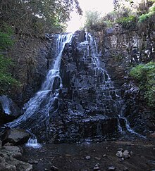
The source region of the Tyhume River is the Hogsback in the Amathole Mountains. It has a large number of small tributaries. Eastern portion is located on slopes of a large height step, and therefore the water from the edge of a powerful Dolerit - bearing passage falls in waterfalls with a height of over 10 meters in depth. The most famous are the Kettlespout , Swallowtail , Madonna and Child and The 39 Steps waterfalls near Hogsback Pass. The western area of the headwaters lies on the northern flank of the Menziesberg . The abundance of water here is so high that a small reservoir (Plaatjieskraal Dam) was created for the village of Hogsback. Annual precipitation amounts of over 1000 mm are typical here.
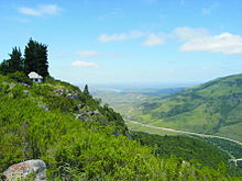
Below the height of the Hogsback Pass, the many small watercourses merge to form the Tyhume River in a trough-shaped valley that quickly flattens out to the south.
A reservoir was created at the former Binfield Farm, which plays an important role in the Amatole Water Project of the provincial government. The water reservoir is named Tyumerivier Dam or Binfield Dam . Several other small ponds in the immediate vicinity of the dam are used to regulate water for the farmland. The amount of precipitation in the Hogsback and in the entire Amathole region, which is comparatively very high for the Eastern Cape, makes drinking water production particularly useful here. Before the construction of these water regulation systems, the settlements and former stations of the Lovedale Mission suffered repeated damage from rapidly increasing floods until the 20th century.
After the course of the Tyhume River has left the valley named after it on the southern slope of the Amathole Mountains, it passes the small town of Alice . In the northeastern urban area there are some small ponds that are in close proximity to the river. From here the river meanders to its confluence with the Keiskamma River.
The lateral tributaries of the Tyhume River are insignificant, there are, among others, the Ncera, Mbashe, Evergreen Stream, Gwali and Kwezana.
Geological conditions
Its headwaters and upper catchment area are mainly characterized by Paleozoic rocks. These are sandstones , slate and gray silt-like rocks of the Balfour Formation within the Beaufort Group . In many places, the watercourses in the headwaters come into contact with dolerites in the form of dykes and tunnels. These subsurface conditions continue in the Tyhume Valley and the flat, undulating landscape around Alice. In the vicinity of this city, the river has created significant Quaternary deposits.
In the lower reaches, south of Alice, only silt rocks and sandstones predominate, both from the Middleton Formation of the Upper Permian .
Protected areas
In the headwaters of the Tyhume River there are remains of the natural forest in the Amathole Mountains. To protect this sensitive and threatened ecosystem, the Auckland Nature Reserve (218 hectares) was created. There are also specimens of the Outeniqa Yellowwood tree ( common afro yellowwood ). Most of this nature reserve lies in the catchment area of the Tyhume River.
history
The Tyhume Valley is a traditional settlement area of the Xhosa and was hotly contested as a coveted farmland in the border wars of the 19th century. The road leading to the Hogsback Pass was of strategic importance.
In the 19th century, the Lovedale Mission operated a few stations in the settlements of the valley and in this way promoted the education of men and women from the native Xhosa population. At that time, large areas of the Tyhume Valley belonged to the Victoria district . In 1848 the military established small fortified stations in Auckland, Ely, Juanasberg and Woburn, because at that time the border line between the Cape Colony and British Kaffraria ran in the valley . As a result of this development, the colonial troops opened the largest fort in the border regions of the Cape Colony in 1847 near what was then Lovedale Mission . It was named after Colonel Hare, the former lieutenant-governor of the Eastern Province, and had room for 560 infantry and 100 cavalrymen .
Today (2009) the valley is densely populated with scattered Xhosa settlements. The old military road to the pass is the R 345 regional road between Alice and Cathcart .
literature
- TV Bulpin: Illustrated guide to southern Africa . Reader's Digest Ass. South Africa, Cape Town 1985, ISBN 0-947008-17-9
- Robert HW Shepherd: Lovedale South Africa. The Story of a Century 1841-1941 . Lovedale (The Lovedale Press) 1940
- James Wells: The Life of James Stewart. London (Hodder and Stoughton), 1909
- Geological map of South Africa 1: 250.000, Sheet 3226 King William's Town
- 3226 King William's Town , 1: 250,000, topo-cadastral, Mowbray (Chief Director of Surveys and Mapping Privat Bag Mowbray) 1985
- 3226 DD Alice , topographic map 1:50 000, 4th ed., Mowbray (Chief Directorate Surveys and Mapping) 2002
- 3226 DB Seymour, topographic map 1:50 000, 4th edition, Mowbray (Chief Directorate Surveys and Mapping) 2002
Individual evidence
- ↑ Robert HW Shepherd: Lovedale 1940, pp. 116-117
Web links
- Agricultural project in the Tyhume Valley
- Infrastructure map of the Local Municipality Nkonkobe
- Amatola Forest complex ( Memento of March 2, 2012 in the Internet Archive ) (PDF; 20 kB)


