Hogsback (South Africa)
| Hogsback | ||
|---|---|---|
|
|
||
| Coordinates | 32 ° 36 ′ S , 26 ° 56 ′ E | |
| Basic data | ||
| Country | South Africa | |
| Eastern Cape | ||
| District | Amathole | |
| ISO 3166-2 | ZA-EC | |
| local community | Raymond Mhlaba | |
| height | 1347 m | |
| Residents | 1029 (2011) | |
| founding | around 1883 | |
|
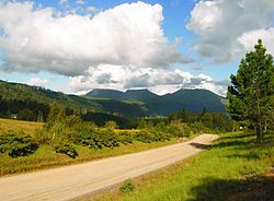
View to the Three Hogs , street within the village of Hogsback
|
||
Hogsback is a village and a ridge within the Amathole Mountains in South Africa . The forest settlement is part of the Local Municipality Raymond Mhlaba in the Amathole district and is located in the South African province of Eastern Cape .
Geographical location
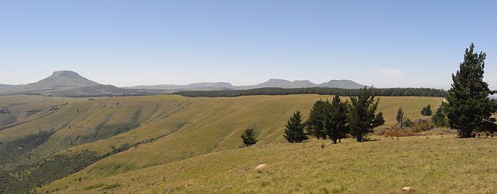
The village of Hogsback is located in a mountain landscape 30 kilometers north of the small town and administrative seat of Alice . The highest individual elevations in this mountainous region are Gaika's Kop (1963 m) and Hog One (1937 m). In the north-west lies the striking and isolated elevation of the Elandsberg (2,016 m). Hogsback itself is at an altitude of 1,347 meters above sea level. The nearest major settlements are Cathcart in the north , Fort Beaufort in the southwest and King William's Town in the southeast .
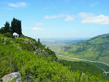
On the north-eastern edge of Hogsback, the Tor Doone (1564.9 m) elevation with its observation tower provides a wide view of the local situation.
Population and employment situation
Families of black and white African origins as well as immigrants from numerous European countries live in Hogsback. The number of residents in the municipality according to the 2011 census is about 1,029 people.
The Anglican parish of St. Patrick on the Hill in the diocese of Grahamstown has a small church building in the upper part of the village, which was built in 1935 and is available to other religious communities.
The majority of the black population belongs to the Xhosa people. The Xhosa are mainly employed in forestry, the service sector and in tourist facilities. More workers commute daily from the Xhosa settlements in the lower landscape ( Tyhume Valley) between Hogsback and Alice. The white population is in some cases supraregional entrepreneurial. Another part runs tourism companies in the Hogsback area or supplies the region with garden products. In addition, many people of retirement age live here.
The Amathole Forestry Company , represented here with a part of its business, operates forestry in the higher-lying landscape areas. It is being reforested on a large scale and in this way the water retention capacity of the landscape is increased. It is the largest employer in this region.
The hotel companies are among the most important employers. The accommodations are partly built in the cottage style and are partly reminiscent of traditional construction methods.
There are clear differences in the income situation between the two population groups.
history
In the highlands north of Hogsback you can find old rock paintings by the San . With the development of African farms and English colonial structures, people of the Xhosa ethnic group came to the area as slaves and later farm workers. The few San groups were driven out, exterminated or assimilated.
In the armed conflict around 1852, British troops fought the Xhosa in the Amathole Mountains with varying success. Eventually the Xhosa were ousted and many small forts were built in the region to secure British rule. In 1857, 50,000 Xhosa died of starvation and more left the region. Due to a fateful prophecy , they killed their cattle and destroyed the crops. A renewed uprising against the British colonizers did not take place in this way and was never attempted again. This ends the border conflicts in this region.
As a result, Europeans immigrated to the largely depopulated country. Since the 19th century, white families have been increasingly farming here and have thus shaped the modern culture of the country.
During the border wars of the 19th century, the Hogsback Pass road played an important role in the transport of military goods and the passage of troops. After the ascent from the Tyhume Rivier valley, a rest area was necessary for this purpose.
The forest settlement of Hogsback is located on an old road connecting the farmland west of King William's Town and the farm area in the highlands south of Cathcart. For ox wagons and other passers-by, the Hogsback Pass was an altitude that could only be overcome with great effort. A rest station on the steep mountain ascent was used for this purpose, which also enabled the cattle to be watered before entering the relatively dry grassland. According to oral tradition, farms are said to have existed in the region as early as 1820.
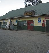
What is certain is that in 1883 there was a rest station with accommodation, washing facilities and horse rest on the old road. The Hotel Hogsback Inn has some old photographs from that time, the historic buildings of which are still integrated into the existing complex. It marks the location of the old resting place.
Surname
The origin of the name Hogsback is established today with the shape of the striking mountains (Hogsback Mountains). A steep rocky edge, the demolition of free-standing intrusive rock , characterizes the three elevations lying in one line. The vertical fissures and slight curvature of the horizon line make these three mountains look like the bristle-covered backs of pigs.
geology
Volcanic processes are responsible for the formation of the Hogsback Mountains. The region around Hogsback and the entire peaks of the Amathole Mountains are part of the Karoo main basin and are shaped by the sedimentary layers of the Beaufort group (mainly sandstone of the Balfour Formation and Mudstone), which were formed in the Upper Permian around 255 million years ago was mostly complete. The fine-grained sandstones have a high density, quartzitic character and a pronounced band structure. Their color is gray to light beige in various shades, sometimes in combination with rust-brown structures.
In the higher lying grasslands , sandstones of the Katberg Formation from the Middle Triassic (around 240 million years) are widespread and deposited in the aforementioned Permian layers.
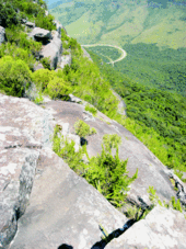
The sedimentary structures of the Beaufort group are mostly hidden under the vegetation and only appear in those places that were formed by deeper cuts in the few larger watercourses. Occasionally they mark themselves as characteristic lines of the grassland in areas of latent or more intense soil erosion .
The formation of the mountain relief in the Amathole Mountains came about through widespread volcanic and sub-volcanic activities about 140 million years ago, which left visible structures on and in the sediments of the Beaufort group . Elongated crevices , filled with igneous rock, crisscross the landscape in an irregular manner. Dolerite , lavas and occasionally strongly decomposed basalts can be recognized as characteristic rocks of the former volcanic and tectonic processes in the area. Point-shaped outflows of igneous rock have created singular elevations, for example the mountain Gaika's Kop .
Several fracture zones have caused considerable gradations in the relief around Hogsback, which visibly protrude from the forest zones and grassland in various places and occasionally also have horizontal intrusion zones with partially solidified lava outflows. From some vantage points, distinctive rock formations can be seen, which are evidence of the outflow of formerly liquid lavas into the short crevice valleys (very well formed at The Edge property , up to 400 meters of steep drop) and in places contain many gas inclusions.
The gradations in the terrain interrupt some streams and cause their water to tumble from considerable heights (e.g. Swallow Tail Falls , Kettle Spout Fall , Madonna and Child ).
The erosion forms of the rocks that can be observed are clearly visible. The dolerite masses show on the surface some pronounced contours of the so-called wool sack shapes . In the scree fields that accompany them, significant shell-shaped flaking occurs as weathering phenomena.
In the near-surface areas of the undulating highlands, conspicuous coarse pebbles from dolerites and the Karoo sandstones are mixed in.
Natural space
The scattered settlement of Hogsback, dominated by the forest, extends over a large area at an average altitude of around 1,300 meters above sea level. NN.
On the slopes of the Hogsback region sloping down to the plains, and especially in the deeply cutting short valleys, parts of the region's original forest stand are still present. These forest stands are predominantly fragmentary and are accompanied by modern afforestation. In the higher regions the terrain changes into a hilly plateau, which is framed by the highest elevations ( Hog one , Hog two , Hog three , Gaika's Kop and Menziesberg ). These areas form an almost untouched meadowland that is only used to a small extent as pasture today. Ecologically valuable wet meadows with a specific plant community extend along most of the watercourses . Modern afforestation brings conifers into the landscape of this highland.
The natural water system around Hogsback including the neighboring mountain areas of the Amathole Mountains has recently been used intensively for the production of drinking water in the metropolitan municipality of Buffalo City . The Tyhume Rivier Dam , built south of Hogsback in the Tyhume Valley, also serves this purpose . The main drainage of the highlands takes place north to the Queenstown region, in the Groot-Keirivier. The large-scale afforestation with conifer stands around Hogsback favor the water retention capacity of this landscape.
Parts of the region around Hogsback are now protected as a nature reserve ( Auckland Nature Reserve ). The natural forest stands, their worth of protection and the necessary public awareness for this sensitive ecosystem gave rise to the establishment of an interest group, Friends of the Indigenous Forest (FIF), in Hogsback.
Attractions
Hogsback is a popular vacation destination for residents of the coastal cities of East London and Port Elizabeth . The main attractions are the species-rich flora, landscaped gardens and the impressive landscape.
- The natural space
The region is visited by numerous holiday guests and hiking tourists. Many indigenous flowering plants live in the forests and meadow areas ( grasslands ). These include rare soil plants such as Disa venusta , Disa lugens , Disa scullyi , Disa tysonii , Schizochilus zeyheri and Eulophia meleagris (all Orchidaceae ), Aloe pratensis ( Asphodelaceae ) and Dierama pulcherrimum ( Iridaceae ). The Auckland Nature Reserve is designed to protect remnants of the native forest flora. Important parts of it are in the inaccessible valley between the Menziesberg and The Edge corridor in the village of Hogsback.
- Arboretum
Around 1930, an arboretum was laid out in the middle of the Hogsback forest settlement . The area below the small waterfall 39 Steps Waterfall has a system of paths and many botanical plant signs. A special attraction are five specimens of redwoods ( Sequoia sempervirens ) from California, which are now considerable. Continuous maintenance of the arboretum was not always possible. The Hogsback Garden Club has been trying to protect and preserve this landmark since the early 1980s. The Hogsback Chamber of Business is involved.
- Hogsback Gardens

Around 1900, settlers mainly from Alice, Fort Beaufort and King William's Town used the vegetation and relatively water-rich altitude near the Hogsback Mountains as a destination for summer vacation. The cool and temperate climate allowed rest and relaxation. This also increasingly attracted visitors from more distant places such as East London and Grahamstown , who acquired existing farm areas and converted them into garden plots. The special value of these gardens consists mainly in the now very old trees and bushes; often there are rhododendrons , azaleas , magnolias or camellias from Asia.
In today's Hogsback, the Hogsback Garden Club, founded in 1981, is particularly committed to its historical and horticultural heritage. The aim of this association is to promote all horticultural activities that serve to maintain and expand, as well as contact with external partners.
For interested visitors, guided tours of the garden are possible by appointment. The Applegarth Gardens , which were laid out after 1945 by the confectionery manufacturer Herbert Wilson from East London, are considered a particularly outstanding horticultural attraction . Wilson built a Scottish-style country house here, made of local sandstone and basalt. Around this country house he laid out a garden with a comprehensive system of paths on the gently sloping terrain. The formerly larger garden area, now only 3.9 hectares in size, was designed with the participation of horticultural experts from Kew Gardens (London). The old stock consists mainly of plant varieties of non-African origin. There are numerous splendid rhododendrons and azaleas. More recently, the plant population has been supplemented by attractive native species. The dense vegetation ensures a retreat for the local fauna, especially the bird world, and enables visitors to observe various animals. Applegarth Gardens is a member of the Royal Horticultural Society through the current owner .
A resident artist has set up sculptures on a plot of land that are accessible to the public in the Ecoshrine sculpture garden .
- Country Home Hobbitton on Hogsback
The country home Hobbiton on Hogsback enables schoolchildren from South Africa to spend a varied holiday in an educational natural environment. This facility was created in 1947 by the South African Women's Aviation Association . It served the purpose of offering war orphans a recreational stay in an interesting landscape.
Today the Landheim is an outdoor education center for South African students who come from needy backgrounds. Their stay is financed by donations and income from the stay of paying school classes. In addition to a few permanent employees, numerous volunteers from Germany and abroad work here. For young visitors, the adventure playgrounds, a challenging climbing tower and the Tolkien Way leading into an enchanted forest landscape are particularly worth seeing and experiencing.
The location of the property is worth mentioning. From the buildings on the slightly inclined slope, the visitor has an excellent panorama of the Hogsback region in front of him. The view extends from the mountain Hog One to the east past a high waterfall to the wooded private property in the west. When the weather is clear, there is also a distant view of the Tyhume Valley.
tourism
The Hogsback region has restrained popularity among tourists. The demand comes predominantly from domestic population groups. With suitable guidance systems and publications that pay tribute to the special natural area, additional tourism potential could be tapped. Numerous overnight accommodations in the form of cottage offers are available in different quality in addition to three hotels.
There is no connection with public transport.
myth
Among the residents of Hogsback there is the belief that the South African-born British writer JRR Tolkien (1892 * in Bloemfontein ) in the remote and somewhat enchanted acting mountains and forests in childhood Visit major inspiration for his fantasy novel The Lord of the Rings get Has. No evidence is known to support this assumption.
Tolkien's mother left what is now South Africa with her children in 1895 and they grew up in Great Britain. Tolkien found his professional and family life there from then on. The father died a year after the family left South Africa and they never returned.
In the 1970s, Tolkien attended the University of Cape Town's English Department .
With regard to the myth, it is revealing that Tolkien's youth book The Hobbit , published in 1937, is the origin for the naming of the youth camp Hobbiton on Hogsback , established in 1947 . In this fantasy novel , hobbits are small human-like creatures who like to hide.
Jack Press, the first director of the holiday and recreation camp, read texts from The Hobbit or There and Back Again to the children who were staying here in the post-war years . His efforts can be seen as an experience-based approach to inspire those children to actively explore the mountain and forest landscape of Hogsback through exciting youth literature.
Hogsback's supposed inspirational reference to Tolkien's works is a legend. In fact, the opposite effect can be assumed. Tolkien's novels charmed some of the Hogsback residents in unusual ways. Some felt this beautiful landscape of the Eastern Cape reflected in their works and expressed their individual appreciation for their novels through the rumored myth.
literature
- TV Bulpin: Illustrated guide to southern Africa . Reader's Digest Ass. South Africa, Cape Town 1985, ISBN 0-947008-17-9 .
- DI Cole: The building stones of Cape Town . Council for Geosciences, Cape Town 2002, ISBN 1-919908-19-6 .
- John Manning: Eastern Cape, South African Wild Flower Guide 11 . Botanical Society of South Africa, National Botanical Institute, Cape Town 2001, ISBN 1-874999-23-6 .
- John Manning, Colin Paterson-Jones: Photographic guide to the wildflowers of South Africa . Briza Publications, Pretoria 2003, ISBN 1-875093-42-7 .
- Suvarna Parbhoo: Hogsback, Wildflower Field Identification Guide . Self-published by CREW, 2007.
- TL Webb et al: Handbook of South African Natural Building Stone . Cape Town 1967.
- 3226 DB Seymour. (topografical map 1: 50,000), 4th edition, Pretoria 2002.
- Geological map of South Africa. 1: 250,000, Sheet 3226 King William's Town
Web links
- Hogsback website (English)
- Biosphere Reserve ( Memento from September 5, 2008 in the Internet Archive )
- Applegarth Gardens (English)
Individual evidence
- ↑ Hogsback, South Africa Page ( English ) Falling Rain Genomics, Inc. . Retrieved May 27, 2010.
- ↑ 2011 census , accessed November 22, 2013

