Elandsberg
| Elandsberg | ||
|---|---|---|
|
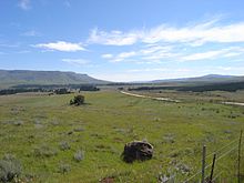
View of the Elandsberg from the south, in the foreground the valley of the Elandsriviers |
||
| height | 2016 m | |
| location | north of Alice in South Africa | |
| Mountains | single mountain | |
| Coordinates | 32 ° 29 '47 " S , 26 ° 52' 37" O | |
|
|
||
| rock | Sandstone | |
The Elandsberg is a table mountain -shaped singular elevation in the South African province of Eastern Cape , which is located between the winter mountains to the west and the Amathole mountains to the east .
geography
The Elandsberg reaches 2016 meters at its highest point. Its maximum extent from northwest to southeast is about seven kilometers and in the northeast to southwest about five kilometers.
The precipitation falling in the area of the Elandsberg is absorbed by the Elands River ( Elandsrivier ) and fed to the Kat River . The Elands River has several small tributaries on the steep southwest slope of the elevation, where its valley cuts deeply. In a northerly direction, a stream drains the plateau of the mountain into the Klipplaat River ( Klipplaatrivier ). On its northeastern flank, the steep drop is somewhat less and merges into a predominantly grass-covered highland, which is part of the fertile hinterland of the Amathole Mountains.
There are no urban settlements in the Elandsberg area . On its northern and eastern flanks there are scattered farms that mainly breed cattle based on the abundance of water in the region . For this reason, the few traffic routes are not or only slightly paved. They are used for agriculture in this area.
To the west passes the regional road R67, which runs from Fort Beaufort to Queenstown . Between the Amathole Mountains and the Elandsberg lies the Hogsback Pass, whose now less important road from Alice opens up the fertile highlands behind the Amathole mountain ranges and finally reaches the small town of Cathcart further north .
Part of the Elandsberg is part of the Hogsback State Forest . There are reforestation areas on the lower slopes in the south .
geology
The mountain range consists of sandstone and shale clays of the Beaufort group with dolerite - intrusions in the form of storage corridors.
literature
- 3226 King William's Town, 1: 250,000 . topo-cadastral, Mowbray (Chief Director of Surveys and Mapping Privat Bag Mowbray) 1985
- Geological map of South Africa 1: 250.000, Sheet 3226 King William's Town


