Gaika's Kop
| Gaika's Kop | ||
|---|---|---|
|
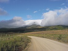
Gaika''s Kop as seen from the south over the Grasslands |
||
| height | 1963 m | |
| location | north of Alice in South Africa | |
| Mountains | single mountain | |
| Coordinates | 32 ° 32 '46 " S , 26 ° 57' 7" O | |
|
|
||
| rock | Dolerite and sandstone | |
The mountain Gaika's Kop ( English Gaika's Hill , German " Gaika's head" ) is a striking and isolated elevation in the Amathole Mountains of the South African province of Eastern Cape . With its summit height of 1963 meters, it towers above the surrounding highland area by around 500 meters. From its flanks and the summit there are distant views in all directions of the region when the weather is clear.
Location and natural environment
This elevation is on the edge of a highland that is surrounded by the Amathole Mountains to the southwest. The mountain and its immediate surroundings are predominantly unforested and, unless the rock is present, mainly has a thick grass cover.
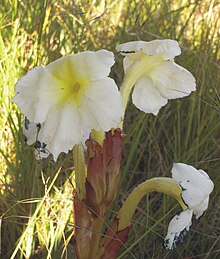
The areas of the highlands adjoining the mountain to the south are being planted as part of a reforestation program and are already bearing coniferous forest . Here and in the eastern flank area, surface water collects in small streams, which flows off in a northerly direction through the Klipplaatrivier . The relative abundance of water in the area around the mountain gives the species-rich grassland its livelihood. Some rare plants can be seen here, such as the great ink flower ( Harveya speciosa ).
To this day, the region around the mountain is used as grazing land, but not as intensively as it was before 1994. These are the areas of the farms Fenfield, Clifton, Dunskye and Cooling.
Paths to the summit
The easiest way to reach the summit is from the west side. Here an observation tower has been built on a sloping backrest at about 1620 meters in order to get an observation possibility over the area in the direction of the village of Hogsback . This tower can be reached on unpaved roads that branch off from the regional road R 345, which runs past to the west and north-west, in the upper part of Hogsback. Today it is only a ruin.
The old access was the now rarely used Michel's Pass , whose little paved road leads from the west up through the valley of the Elandsrivier and on the western slope from Gaika's Kop on the highlands joins the younger Hogsback Pass road.
geology
The mountain consists of a dolerite core , which was formed at this point by a chimney-like intrusion, penetrating the Karoo sediment layers and overlaying them in places. In the course of these processes, the sandstone layers of the Katberg formation (within the Beaufort group ) were raised on the flanks of the mountain. Dolerit- Dykes are walking towards the mountain. In places they mark themselves in the area as strip-shaped debris deposits or areas with little vegetation and rocky subsoil.
The sandstone layers at its foot have abundant spring horizons , which ensure the favorable water supply in the area surrounding the mountain.
Name and story
Gaika's Kop is named after the Xhosa chief Gaika (in isiXhosa : Ngqika, * 1797; † November 13, 1829), who was a major figure as a military leader on the side of the Xhosa tribes in the so-called border wars at the beginning of the 19th century kicked. He was the father of the later Xhosa leader Sandile (* 1820, † 1878).
At the time of these wars, the region around the mountain was a battle and transit area for the British troops and the Xhosa people, which required constant security on both sides. For this purpose, the colonial authorities set up an observation post at Fort Michel (alternative spelling: Fort Mitchell) four kilometers south of the summit, which was placed on the Tor Doone hill (1565 m) in an ideal position to see Gaika's Kop. From here the activities of the Xhosa warriors around Gaika's Kop and in the Tyhume Valley could be followed closely. This complex, which is now only in ruins, was the last point in a chain of such forts in the region between King William's Town and Fort Beaufort, which were set up to secure the contested areas. Conversely, the Xhosa warriors observed the troop movements of the English from this mountain. Around 1880, a few kilometers south of Gaika's Kop at the Hogsback Pass, a rest station for horse-drawn vehicles was built.
The country around Gaika's Kop is a region that was caught between conflicting interests for two reasons. The annual favorable precipitation situation (more than 1000 mm / year) on the entire mountain range of the Amathole Mountains ensures a relatively favorable water flow in the watercourses for the Eastern Cape and therefore the highlands, which reach far to the north and east, are good pasture and farmland. The region is a historical settlement area of the Xhosa.
Gaika's Kop was processed as a point in the exploration of the Amathole Mountains in the poem In the Mist: Hogsback by Francis Carey Slater (1876-1958).
literature
- John Manning: Eastern Cape, South African Wild Flower Guide 11 . Botanical Society of South Africa, National Botanical Institute, Cape Town 2001, ISBN 1-874999-23-6
- John Manning, Colin Paterson-Jones: Photographic guide to the wildflowers of South Africa . Briza Publications, Pretoria 2003, ISBN 1-875093-42-7
- Nick Norman, Gavin Whitefield: Geological Journeys . Cape Town (Struik Publishers) 2006 ISBN 1-77007-062-1
- 3226 DB Seymour (topografical map 1: 50,000), 4th edition, Pretoria 2002
- Geological map of South Africa 1: 250.000, Sheet 3226 King William's Town
Individual evidence
- ^ Jeanette Eve, Basil Mills: A literary guide to the Eastern Cape. Double Storey, Cape Town 2003, ISBN 1-919930-15-9 , p. 311
Web links
- Picture on Panoramio
- Data on summits on the air
- Description of the region ( memento of March 2, 2012 in the Internet Archive ) (PDF; 20 kB)
- History of Hogsback


