Britstown
| Britstown | ||
|---|---|---|
|
|
||
| Coordinates | 30 ° 35 ′ S , 23 ° 30 ′ E | |
| Basic data | ||
| Country | South Africa | |
| North Cape | ||
| District | Pixley Ka Seme | |
| ISO 3166-2 | ZA-NC | |
| local community | Emthanjeni | |
| Residents | 3843 | |
| Website | 2011 (english) | |
|
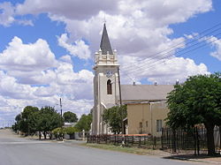
Britstown Low German Reformed Church
|
||
Britstown is a small town in the North Cape Province in South Africa in the middle of the Karoo semi-desert region . Britstown is part of the Emthanjeni parish within the Pixley Ka Seme district . In 2011 the city had 3,843 inhabitants.
history
Britstown was founded during the diamond fever in the Kimberley region . Diamond hunters paused here on their way between Victoria West and Kimberley as they rushed into the diamond fields. A settlement emerged whose residents offered new horses, fodder, refreshments and overnight accommodation. Even musical entertainment offered the travelers variety. The carriage transport companies Fuller and Gibson were the first to stop here. In 1889 Britstown was connected to the railway line to Kimberley via the town of De Aar .
The city is named after Hans Brits , who settled here on the Gemsbokfontein farm after accompanying the African explorer David Livingstone on a trip to the hinterland of the Cape Colony . Brits sold part of the farm, where a community hall and a chapel were built next to the meeting points for diamond hunters in 1877 . This happened after Brits had found a reliable source of income in the travelers, right after the first diamonds were found in Kimberley and Hopetown.
Travel through the city increased even more when gold was found in the region . Well-known mine owners like Cecil John Rhodes visited Britstown regularly. Its significant geographical connection extended to South West Africa (today: Namibia). A private irrigation system was designed for Britstown in 1885 and discontinued in 1954. The commissioned Smart Syndicate group built two dams whose water allowed the planting of alfalfa and wheat . Karakul sheep and Clydesdale horses were bred with this food source . In 1961 one of the dams was destroyed by a tidal wave and in 1964 it was rebuilt with government funds.
Britstown gained city status in 1889. For decades, families sent their children from far-flung farms to Britstown boarding school. However, their operations ceased in 2003.
Geographical location
Britstown is located in the center of the Central Karoo, exactly halfway on the N12 between Cape Town and Johannesburg . Britstown is around 700 kilometers away from both cities. The next largest cities are De Aar, 50 km east, Strydenburg , 79 km north, Prieska , 124 km west and Victoria West, 101 km south. Kimberley is 253 km away. The N10 crosses in Britstown .
climate
As in the rest of the Karoo, Britstown's climate is arid . The amount of rain is 250 mm per year.
Stone age culture
The indigenous people of the Karoo, San , wandered the entire Karoo. In the Britstown area, too, they left petroglyphs and paintings on stones and in caves or overhangs. Petroglyphs can be seen on the Brakwater Farm, ten kilometers away . The majority of the images show eland , ostrich and elephant . Drawings and engravings of giraffes , reptiles , goats and people drawn in stick figure style are also preserved on the Maritzdam farm. Archaeologists such as M. Burkitt, A. Goodwin and Gerhard and Dora Focke have studied art from the Stone Age in the Karoo.
Boer War
During the Second War between the Boers and the English (1899-1902) 550 soldiers of the British Army were stationed in Britstown. They had the task of defending the area around the Orange River and the city's rail link with another 1,050 soldiers and to push back advancing Boer troops. However, they were routed by the Boers and their rebels during the advance and had to retreat to Britstown. Even the supply of 3,000 more British soldiers from Cape Town did not achieve the hoped-for goal. In the course of a bloody guerrilla war there were heavy losses on both sides.
museum
The Britstown Museum is housed in the town's former church.
Web links
- Information about Brit Town (English)
- Detailed information on the city and regional history (English)
Individual evidence
- ↑ 2011 census , accessed November 18, 2013

