Victoria West
| Victoria West | ||
|---|---|---|
|
|
||
| Coordinates | 31 ° 24 '11 " S , 23 ° 7' 14" O | |
| Basic data | ||
| Country | South Africa | |
| North Cape | ||
| District | Pixley Ka Seme | |
| ISO 3166-2 | ZA-NC | |
| local community | Ubuntu | |
| height | 1272 m | |
| surface | 79 km² | |
| Residents | 8254 (2011) | |
| density | 104.5 Ew. / km² | |
| founding | 1843 | |
|
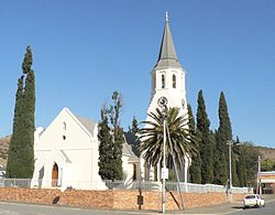
Dutch Reformed Church in the city center
|
||
Victoria West (until 1855 Victoria ) is a place in the South African province of Northern Cape . It is the seat of the municipality of Ubuntu in the district Pixley Ka Seme .
geography
Victoria West has 8254 inhabitants (as of 2011). Around 70 percent of the population counted themselves among the colored in 2011 , 82 percent named Afrikaans as the main language used. The place is in the Karoo on the Brak River. To the west, the river is dammed to Victoria West Dam . The surrounding area is characterized by flat plateaus, with a 1440 meter high table mountain immediately to the northwest of the city . The climate is arid .
history
The place was founded in 1843 on the territory of the Kapokfontein and Zeekoegat farms to establish a congregation of the Dutch Reformed Church . In 1844 it was named after the then British Queen Victoria . Since 1855 it has been called Victoria West to distinguish it from the Victoria district in the east of the Cape Colony . An Anglican church was also built in 1869 . On February 27, 1871, the Brak River flooded the city and claimed around 60 dead and injured among the approximately 1,000 inhabitants. In the following year a weir was built in the river. In 1881 the railroad coming from Cape Town reached Victoria West Road station, which was later renamed Hutchinson. From there a branch line was set up via Victoria West to Calvinia in the west.
Economy and Transport
Victoria West is on the N12 , which runs from Britstown in the north to the N1 and to Beaufort West in the south, and on the R63 , which connects Carnarvon in the north-west with Graaf-Reinet in the south-east. The Hutchinson – Calvinia railway is used for freight traffic. Victoria West Airport ( ICAO code FAVW) to the east is served by smaller aircraft, but has, among other things, a 1761 meter long runway.
Web links
- History of the city at karoo-southafrica.co.za (English)
Individual evidence
- ↑ a b 2011 census , accessed on February 24, 2017
- ↑ a b History of the city at karoo-southafrica.co.za (English), accessed on February 24, 2017
- ↑ Description at handbook.aero (English), accessed on February 24, 2017


