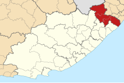
Alfred Nzo (District)
| Alfred Nzo Alfred Nzo District Municipality |
|
|---|---|
 |
|
| Basic data | |
| Country | South Africa |
| province | Eastern Cape |
| Seat | Mount Ayliff |
| surface | 10,731 km² |
| Residents | 801,344 (October 2011) |
| density | 75 inhabitants per km² |
| key | DC44 |
| ISO 3166-2 | ZA-EC |
| Website | www.andm.gov.za (English) |
| politics | |
| mayor | Sixolile Mehlomakhulu |
Coordinates: 30 ° 48 ′ S , 29 ° 22 ′ E
The district Alfred Nzo ( English Alfred Nzo District Municipality ) is located in the South African province of Eastern Cape . 801,344 inhabitants live in an area of 10,731 km² (as of October 2011). The capital is Mount Ayliff .
The district is named after the former ANC Secretary General Alfred Nzo (1925–2000), who was also South African Foreign Minister from 1994 to 1999. The district is one of the poorest in South Africa. Around 24 percent of the population are infected with HIV .
Communities
The district consists of the four parishes Umzimvubu (administrative seat Mount Ayliff), Matatiele (administrative seat Matatiele ), Mbizana and Ntabankulu . Mbizana and Ntabankulu belonged to the OR Tambo district until 2011 .
As an example of the infrastructure here is the water supply for households (HWA = own domestic water connection; ÖWA = public water connection nearby; KWA = no connection to a water supply network):
| local community | Administrative headquarters | surface | HWA | Ö WA | KWA |
|---|---|---|---|---|---|
| Umzimvubu | Mount Ayliff | 2506 km² | 1 % | 35% | 65% |
| Matatiele | Matatiele | 4352 km² | 25% | 59% | 16% |
Web links
- Official website (English)
Individual evidence
- ^ Census 2011. Basic Results. (PDF; 349 kB) Statistics South Africa , accessed on November 27, 2015 (English).
- ↑ Meaning of the name municipalities
- ↑ Circular on territorial reform, p. 5 (PDF file, English; 155 kB), accessed on January 1, 2013
- ^ Community statistics South Africa