Camsell River
| Camsell River | ||
|
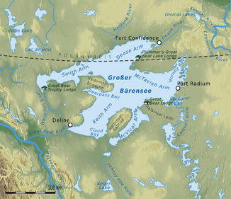
Location of the Camsell River |
||
| Data | ||
| location | Northwest Territories ( Canada ) | |
| River system | Mackenzie River | |
| Drain over | Great Bear River → Mackenzie River → Arctic Ocean | |
| source |
Sarah Lake south of Faber Lake 63 ° 48 ′ 4 ″ N , 117 ° 3 ′ 4 ″ W |
|
| Source height | 241 m | |
| muzzle | to Conjuror Bay ( Great Bear Lake ) Coordinates: 65 ° 40 ′ 0 ″ N , 118 ° 7 ′ 5 ″ W 65 ° 40 ′ 0 ″ N , 118 ° 7 ′ 5 ″ W |
|
| Mouth height | 156 m | |
| Height difference | 85 m | |
| Bottom slope | approx. 0.22 ‰ | |
| length | approx. 380 km | |
| Catchment area | > 31,000 km² | |
| Outflow at the gauge at the outlet of Clut Lake A Eo : 31,100 km² |
MQ 1933/2000 Mq 1933/2000 |
98 m³ / s 3.2 l / (s km²) |
| Right tributaries | Wopmay River , Zebulon River , Calder River | |
| Flowing lakes | Faber Lake , Rae Lake , Hardisty Lake , Hottah Lake , Clut Lake | |
The Camsell River is a river in the Northwest Territories of Canada .
The river has its origin in Sarah Lake . It then flows through a number of other lakes in a northerly direction, including Faber Lake , Rae Lake , Hardisty Lake , Hottah Lake and Clut Lake , before finally flowing into them on the southeastern shore of Great Bear Lake . Its mean discharge is 98 m³ / s, its catchment area covers more than 31,000 km². A major tributary is the Wopmay River , which flows into Hardisty Lake from the northeast.
Individual evidence
- ↑ Natural Resources Canada - The Atlas of Canada - Lakes ( Memento from January 14, 2013 in the Internet Archive )
- ↑ a b c Camsell River at the gauge at the outlet of Clut Lake - hydrographic data from R-ArcticNET
