Cance (Sélune)
| Cance | ||
|
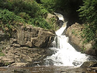
Grande Cascade waterfall near Mortain |
||
| Data | ||
| Water code | FR : I90-0400 | |
| location | France , Normandy region | |
| River system | Sélune | |
| Drain over | Sélune → English Channel | |
| source | in the municipality of Ger 48 ° 40 ′ 29 ″ N , 0 ° 49 ′ 54 ″ W |
|
| Source height | approx. 300 m | |
| muzzle | on the municipal boundary of Bion and Notre-Dame-de-Touchet in the Sélune Coordinates: 48 ° 35 ′ 55 ″ N , 0 ° 57 ′ 22 ″ W 48 ° 35 ′ 55 ″ N , 0 ° 57 ′ 22 ″ W |
|
| Mouth height | approx. 76 m | |
| Height difference | approx. 224 m | |
| Bottom slope | approx. 12 ‰ | |
| length | 19 km | |
| Catchment area | 217 km² | |
| Right tributaries | Cançon | |
The Cance is a river in France that runs in the Manche department in the Normandy region . It rises under the name Ruisseau des Vieux Gués in the Normandy-Maine Regional Nature Park , in the municipality of Ger , generally drains in a south-westerly direction and flows into the Sélune after 19 kilometers at the municipal border of Bion and Notre-Dame-de-Touchet as a right tributary .
Places on the river
Attractions
Shortly before the confluence of the Cançon at Mortain, the Cance forms a waterfall, the Grande Cascade , while the Cançon overcomes the same steep step with the Petite Cascade .
