
Ger (some)
| Ger | ||
|---|---|---|
|
||
| region | Normandy | |
| Department | Some | |
| Arrondissement | Avranches | |
| Canton | Le Mortainais | |
| Community association | Mont-Saint-Michel-Normandy | |
| Coordinates | 48 ° 41 ′ N , 0 ° 47 ′ W | |
| height | 162-341 m | |
| surface | 39.78 km 2 | |
| Residents | 806 (January 1, 2017) | |
| Population density | 20 inhabitants / km 2 | |
| Post Code | 50850 | |
| INSEE code | 50200 | |

Ger is a French municipality with 806 inhabitants (as of January 1 2017) in the department of Manche in the region of Normandy . The municipality belongs to the Arrondissement of Avranches and the canton of Le Mortainais (until 2015: canton of Barenton ). The inhabitants are called Gérois .
geography
Ger is the easternmost commune in the Manche department. It is located about 45 kilometers east of Avranches city center . It belongs to the Normandy-Maine Regional Nature Park . Ger is surrounded by the neighboring communities of Le Fresne-Poret in the north, Tinchebray-Bocage in the east and northeast, Lonlay-l'Abbaye in the east and southeast, Saint-Georges-de-Rouelley in the south and southeast, Barenton in the south, and Saint-Clément -Racoudray in the west and Sourdeval in the northwest.
Population development
| year | 1962 | 1968 | 1975 | 1982 | 1990 | 1999 | 2006 | 2013 |
| Residents | 1,342 | 1,245 | 1.109 | 1,075 | 1,041 | 947 | 863 | 832 |
| Source: Cassini and INSEE | ||||||||
Attractions
- Saint-Matthieu church, built in the early 20th century
- La Croix de Terre Castle
- Pottery Museum

Saint-Matthieu church
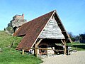
Pottery Museum

