
Folligny
| Folligny | ||
|---|---|---|
|
||
| region | Normandy | |
| Department | Some | |
| Arrondissement | Avranches | |
| Canton | Bréhal | |
| Community association | Granville, Terre et Mer | |
| Coordinates | 48 ° 49 ′ N , 1 ° 25 ′ W | |
| height | 59-128 m | |
| surface | 11.8 km 2 | |
| Residents | 1,089 (January 1, 2017) | |
| Population density | 92 inhabitants / km 2 | |
| Post Code | 50320 | |
| INSEE code | 50188 | |
 Town hall (Mairie) of Folligny |
||

Folligny is a French commune with 1,089 inhabitants (as of January 1 2017) in the department of Manche in the region of Normandy . It belongs to the Arrondissement of Avranches and the Canton of Bréhal (until 2015: Canton of La Haye-Pesnel ). The inhabitants are called Follignais .
geography
Folligny is located about 17 kilometers north-northwest of Avranches . The Thar borders the community in the south. Folligny is surrounded by the neighboring communities of Saint-Sauveur-la-Pommeraye and La Meurdraquière in the north, Équilly in the east and northeast, Hocquigny in the east and southeast, La Lucerne-d'Outremer in the south and Saint-Jean-des-Champs in the west.
history
In 1973 the previously independent municipality of Le Mesnil-Drey was incorporated.
Population development
| year | 1962 | 1968 | 1975 | 1982 | 1990 | 1999 | 2008 | 2013 |
| Residents | 547 | 565 | 791 | 690 | 760 | 777 | 961 | 1,064 |
| Source: Cassini and INSEE | ||||||||
Attractions
- Notre-Dame church from the 17th century
- Saint-Pierre-et-Saint-Paul church in La Beslière from the 18th century
- Notre-Dame-de-l'Annonciation church from the 17th century in Le Mesnil-Drey
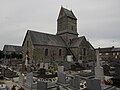
Notre-Dame church in Folligny

Saint-Pierre-et-Saint-Paul church

Notre-Dame-de-l'Annonciation church
.JPG)

