
Pontaubault
| Pontaubault | ||
|---|---|---|
|
||
| region | Normandy | |
| Department | Some | |
| Arrondissement | Avranches | |
| Canton | Pontorson | |
| Community association | Communauté d'agglomération Mont-Saint-Michel-Normandie | |
| Coordinates | 48 ° 38 ′ N , 1 ° 21 ′ W | |
| height | 7-72 m | |
| surface | 1.94 km 2 | |
| Residents | 555 (January 1, 2017) | |
| Population density | 286 inhabitants / km 2 | |
| Post Code | 50220 | |
| INSEE code | 50408 | |
 Mairie Pontaubault |
||

Pontaubault is a French commune in the Manche department and in the administrative region of Normandy . It belongs to the canton of Pontorson and the Arrondissement of Avranches .
geography
The Sélune flows northwest of Pontaubault into the Baie du Mont-Saint-Michel , a bay of the English Channel . Neighboring communities are Céaux in the north-west, Poilley in the east, Juilley in the south-east and Précey in the south-west.
Population development
| year | 1962 | 1968 | 1975 | 1982 | 1990 | 1999 | 2008 | 2015 |
|---|---|---|---|---|---|---|---|---|
| Residents | 375 | 375 | 483 | 473 | 492 | 445 | 468 | 533 |
Attractions
- Saint-André church

Bridge at Pontaubault over the Sélune

Saint-André church
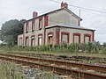
disused Pontaubault station on the Lison – Lamballe railway line

.JPG)

Web links
Commons : Pontaubault - collection of images, videos and audio files