Vains
| Vains | ||
|---|---|---|
|
||
| region | Normandy | |
| Department | Some | |
| Arrondissement | Avranches | |
| Canton | Avranches | |
| Community association | Mont-Saint-Michel-Normandy | |
| Coordinates | 48 ° 41 ′ N , 1 ° 25 ′ W | |
| height | 5-39 m | |
| surface | 8.58 km 2 | |
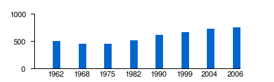
| Residents | 722 (January 1, 2017) | |
| Population density | 84 inhabitants / km 2 | |
| Post Code | 50300 | |
| INSEE code | 50612 | |

Vains is a French municipality with 722 inhabitants (at January 1, 2017) in the department of Manche in the region of Normandy .
geography
Vains is located north of the confluence of the Sée and the Sélune , in the bay of Mont-Saint-Michel with eight kilometers of coastline. Of the 858 hectares, around 140 hectares are salty sheep pastures.
The subsurface consists of slate that is more than 600 million years old.
Vains borders the communes of Marcey-les-Grèves , Bacilly and Genêts .
The community consists of two villages three kilometers away. The main town, where the town hall, church and schools are located, is called Bourg de Vains (village of Vains) by the residents . The other village around the priory is called Saint-Léonard . The priory was long in ruins and has been restored.
Population development