
Saint-Planchers
| Saint-Planchers | ||
|---|---|---|
|
||
| region | Normandy | |
| Department | Some | |
| Arrondissement | Avranches | |
| Canton | Bréhal | |
| Community association | Granville, Terre et Mer | |
| Coordinates | 48 ° 49 ′ N , 1 ° 32 ′ W | |
| height | 17-98 m | |
| surface | 11.96 km 2 | |
| Residents | 1,350 (January 1, 2017) | |
| Population density | 113 inhabitants / km 2 | |
| Post Code | 50400 | |
| INSEE code | 50541 | |
| Website | http://www.mairiestplanchers.fr/ | |
 Town hall (Mairie) of Saint-Planchers |
||

Saint-Planchers is a French commune with 1,350 inhabitants (as of January 1 2017) in the department of Manche in the region of Normandy . It belongs to the Arrondissement of Avranches and the Canton of Bréhal (until 2015: Canton Granville ). The inhabitants are called Pancraciens .
geography
Saint-Planchers is located immediately east of Granville , a small coastal town on the Gulf of Saint-Malo , a few kilometers north of Mont-Saint-Michel . The municipality is divided by the neighboring municipalities of Coudeville-sur-Mer in the north, Saint-Jean-des-Champs in the east, Saint-Aubin-des-Préaux in the south, Saint-Pair-sur-Mer in the southwest, Granville in the west and Yquelon in the Surrounded northwest.
Population development
| year | 1962 | 1968 | 1975 | 1982 | 1990 | 1999 | 2006 | 2013 |
| Residents | 585 | 587 | 643 | 936 | 1,057 | 1,112 | 1,235 | 1,355 |
| Source: Cassini and INSEE | ||||||||
Attractions
- Saint-Pancrace church from the 11th century, renovations from the 15th and 18th centuries
- L'Oiselière priory, Monument historique since 1989
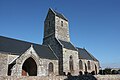
Saint-Pancrace church

Priory of L'Oiselière


Parish partnership
A partnership has existed with the French community of Longchaumois in the Jura département since 2001.